Marble Bar, Western Australia
Marble Bar is a town and rock formation in the Pilbara region of north-western Western Australia. It is well known for its extremely hot weather, with a mean maximum temperature second only to Wyndham, Western Australia.[2]
| Marble Bar Western Australia | |||||||||
|---|---|---|---|---|---|---|---|---|---|
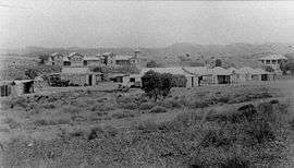 Marble Bar in 1898 | |||||||||
 Marble Bar | |||||||||
| Coordinates | 21°10′12″S 119°44′49″E | ||||||||
| Population | 174 (2016 census)[1] | ||||||||
| Established | 1893 | ||||||||
| Postcode(s) | 6760 | ||||||||
| Elevation | 178 m (584 ft) | ||||||||
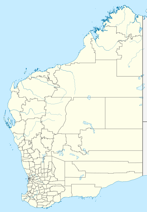
| Location |
| ||||||||
| LGA(s) | Shire of East Pilbara | ||||||||
| State electorate(s) | Pilbara | ||||||||
| Federal Division(s) | Durack | ||||||||
| |||||||||
History
The town was officially gazetted in 1893 following the discovery of gold in the area in 1890 by a prospector named Francis Jenkins who is remembered by the name of the town's main street.[3] The name Marble Bar was derived from a nearby jasper bar mistaken for marble and now known as Marble Bar, which runs across the bed of the Coongan River.
In 1891 the town boasted a population in excess of 5,000 as it experienced a rush on the goldfields.[4]
By 1895 the town had its Government offices built; these are now National Trust buildings. Cut from local stone, the buildings still stand today.
Possibly the most famous building in the town is the Ironclad Hotel built in the 1890s, constructed of corrugated Iron, and given the name by American miners who were reminded of the Ironclad ships from the United States. In 2006, the Ironclad hotel was listed on the Western Australian register of heritage places.[5]
Several large gold nuggets were discovered as a result of the goldrush. The 333 ounce Little Hero nugget, the 413 ounce Bobby Dazzler and the 332 ounce General Gordon nugget were all found in the goldfields around the town.
During World War II, United States Army Air Forces and Royal Australian Air Force heavy bombers were based 25 kilometres (16 mi) away as the crow flies at Corunna Downs Airfield. Allied airmen from the base attacked Japanese forces as far away as Borneo.
The Port Hedland to Marble Bar railway opened on 15 July 1911, costing around £300,000 to build.[6][7] Due to low traffic and high financial losses, the railway closed from 31 May 1951.[8] This railway could be seen as a narrow gauge precursor to the network of standard gauge iron-ore railways that have since been created across the Pilbara.
Climate
Marble Bar has a hot desert climate (Köppen BWh) with sweltering summers and warm winters. Most of the annual rainfall occurs in the summer. The town set a world record of most consecutive days of 100 °F (37.8 °C) or above, during a period of 160 days from 31 October 1923 to 7 April 1924.[9] Although annual temperatures indicate Marble Bar should be within the tropics, with a July (winter) mean of 19 °C (66 °F), it does not have the high precipitation requirements for hot-weather climates to sustain tropical vegetation.
During December and January, temperatures in excess of 45 °C (113 °F) are common, and the average maximum temperature exceeds normal human body temperature for six months each year. Marble Bar receives 159.6 clear days annually. Dewpoint in the summers is between 10 and 15 °C (50 and 59 °F). In contrast to most of the year, winters are warm, with days averaging 27 °C (81 °F), low humidity and clear skies. Nights from June to August can be chilly, occasionally as low as 5 °C (41 °F) but frost is unknown. Even in mid winter however, brief bursts of heat can result in the temperature rising to as high as 35 °C (95 °F) for a few days before dropping back to normal.
Rainfall is sparse and erratic, though variability is significantly less extreme than over the coastal Pilbara – the tenth percentile being 190.9 millimetres (7.52 in) vis-à-vis only 67.4 millimetres (2.65 in) in Onslow.[10] It falls largely between December and March, with occasional rain events from autumn northwest cloudbands up to June. As little as 71.1 mm (2.80 in) can fall in a year; however, during heavy wet seasons when the monsoon reaches well south into the Pilbara, the rainfall can be significantly more – as much as 927.1 millimetres (36.50 in) fell between April 1999 and March 2000, and 797.9 mm (31.41 in) fell in 1980 owing to several tropical cyclones. The most rain recorded in a month is 417.4 mm (16.43 in) in March 2007,[11] and the most in one day 304.8 millimetres (12.00 in) on 2 March 1941.[12]
| Climate data for Marble Bar, Western Australia | |||||||||||||
|---|---|---|---|---|---|---|---|---|---|---|---|---|---|
| Month | Jan | Feb | Mar | Apr | May | Jun | Jul | Aug | Sep | Oct | Nov | Dec | Year |
| Record high °C (°F) | 49.2 (120.6) |
48.3 (118.9) |
46.7 (116.1) |
45.0 (113.0) |
39.5 (103.1) |
35.8 (96.4) |
35.0 (95.0) |
38.0 (100.4) |
42.6 (108.7) |
46.0 (114.8) |
47.2 (117.0) |
49.3 (120.7) |
49.3 (120.7) |
| Average high °C (°F) | 41.0 (105.8) |
39.8 (103.6) |
39.0 (102.2) |
36.0 (96.8) |
30.7 (87.3) |
27.1 (80.8) |
26.8 (80.2) |
29.6 (85.3) |
33.9 (93.0) |
37.6 (99.7) |
40.5 (104.9) |
41.6 (106.9) |
35.3 (95.5) |
| Average low °C (°F) | 26.1 (79.0) |
25.7 (78.3) |
24.8 (76.6) |
21.4 (70.5) |
16.6 (61.9) |
13.2 (55.8) |
11.7 (53.1) |
13.3 (55.9) |
16.7 (62.1) |
20.3 (68.5) |
23.6 (74.5) |
25.5 (77.9) |
19.9 (67.8) |
| Record low °C (°F) | 17.9 (64.2) |
13.9 (57.0) |
15.0 (59.0) |
10.0 (50.0) |
5.6 (42.1) |
1.1 (34.0) |
2.2 (36.0) |
3.9 (39.0) |
5.6 (42.1) |
10.0 (50.0) |
14.4 (57.9) |
17.0 (62.6) |
1.1 (34.0) |
| Average rainfall mm (inches) | 76.3 (3.00) |
87.8 (3.46) |
56.7 (2.23) |
21.9 (0.86) |
23.0 (0.91) |
23.0 (0.91) |
12.6 (0.50) |
6.4 (0.25) |
0.9 (0.04) |
3.8 (0.15) |
9.1 (0.36) |
39.6 (1.56) |
361.1 (14.23) |
| Average rainy days (≥ 0.2 mm) | 7.4 | 7.7 | 4.9 | 1.9 | 2.4 | 2.3 | 1.5 | 0.9 | 0.3 | 0.6 | 1.5 | 4.6 | 36 |
| Average afternoon relative humidity (%) | 26 | 31 | 26 | 23 | 27 | 28 | 24 | 21 | 17 | 16 | 16 | 20 | 23 |
| Source: Australian Bureau of Meteorology[11][12] | |||||||||||||
North Pole
A locality nearby is known as North Pole (21° 05' S. 119° 22' E.). It is the location of rock formations considered to have evidence that puts the origin of life on earth back to 3,400–3,500 million years ago, due to stromatolites in particular rock sequences.[13][14][15][16][17][18][19][20][21][22] However this is disputed, and it is argued that stromatolites older than 3,200 mya are not the result of living organisms (the definition of stromatolites includes both living and abiotic causes), the small conical structures in the Strelley Pool formation (Warrawoona Group) being formed by evaporation and a dome structure from the North Pole chert (also Warrawoona Group) being formed by soft-sediment deformation.[23][24]
See also
- List of weather records
- Pilbara historical timeline
- Pilbara newspapers
- Royal Commission into British nuclear tests in Australia
- Warrawoona Group – in relation to North Pole findings
References
- Australian Bureau of Statistics (27 June 2017). "Marble Bar (L) (Urban Centre/Locality)". 2016 Census QuickStats. Retrieved 5 January 2018.

- "Hottest places by maximum mean temperature in Australia". Bonzle Digital Atlas of Australia. Retrieved 3 August 2018.
- "Marble Bar". The Sydney Morning Herald. 15 January 2008. Retrieved 16 September 2008.
- "About Australia – Marble Bar, WA". 2008. Retrieved 16 September 2008.
- "ABC News – Historic Marble Bar hotel to get heritage listing". 2006. Retrieved 16 September 2008.
- "Port Hedland". The Murchison Times And Day Dawn Gazette. 17 (141). Western Australia. 18 July 1911. p. 3. Retrieved 26 November 2017 – via National Library of Australia.
- "Port Hedland-Marble Bar railway". Geraldton Express. XXXIII. Western Australia. 17 July 1911. p. 3. Retrieved 26 November 2017 – via National Library of Australia.
- "Hedland- Marble Bar railway to close". Northern Times. 75 (21). Western Australia. 24 May 1951. p. 6. Retrieved 26 November 2017 – via National Library of Australia.
- "Marble Bar heatwave, 1923–1924". Australian Climate Extremes. Bureau of Meteorology. Archived from the original on 17 March 2009. Retrieved 21 September 2008.
- Dewar, Robert E; Wallis, James R (1999). "Geographical patterning of interannual rainfall variability in the tropics and near tropics: An L-moments approach". Journal of Climate. 12 (12): 3457–3466. Bibcode:1999JCli...12.3457D. doi:10.1175/1520-0442(1999)012<3457:GPOIRV>2.0.CO;2.
- "Climate statistics for Australian locations: Marble Bar". Bureau of Meteorology. Retrieved 2 February 2019.
- "Climate statistics for Australian locations: Marble Bar Comparison". Bureau of Meteorology. Retrieved 21 September 2008.
- Douglas, Kim. (1980) "Oldest forms of life on Earth found in WA rocks". North Pole Gold Mine (W.A.) Australian women's weekly, 5 November 1980, p.36-37
- Dunlop, J.S.R.; Muir, M.D.; Milne, A.; Groves, D.I. (1978). "A New Microfossil Assemblage from the Archaean of Western Australia". Nature. 274 (5672): 676–678. Bibcode:1978Natur.274..676D. doi:10.1038/274676a0.
- Walter, M.R.; Buick, R.; Dunlop, J.R.S. (1980). "Stromatolites 3,400-3,500 Myr Old from the North Pole Area, Western Australia". Nature. 284 (5755): 443–445. Bibcode:1980Natur.284..443W. doi:10.1038/284443a0.
- Buick, R.; Dunlop, J.S.R.; Groves, D.I. (1981). "Stromatolite Recognition in Ancient Rocks and Appraisal of Irregularly Laminated Structures in an Early Archaean Chert-Barite Unit from North Pole, Western Australia". Alcheringa. 5 (3): 161–181. doi:10.1080/03115518108566999.
- Schopf, J. William; Packer, Bonnie M (1986). "Newly discovered early Archean (3.4–3.5 Ga Old) microorganisms from the Warrawoona Group of Western Australia". Origins of Life and Evolution of the Biosphere. SpringerLink. 16 (3–4): 339–340. Bibcode:1986OrLi...16..339S. doi:10.1007/BF02422059.
- Buick, R (1988). "Carbonaceous Filaments from North Pole, Western Australia: Are They Fossil Bacteria in Archaean Stromatolites? A reply". Precambrian Research. 39 (4): 311–317. Bibcode:1988PreR...39..311B. doi:10.1016/0301-9268(88)90024-1.
- Lunar and Planetary Science XXXV (2004): "Characterization Of The Organic Matter In An Archean Chert (Warrawoona, Australia)."
- Derenne, Sylvie; Robert, François; Skrzypczak-Bonduelle, Audrey; Gourier, Didier; Binet, Laurent; Rouzaud, Jean-Noël (2008). "Molecular evidence for life in the 3.5 billion year old Warrawoona chert". Earth and Planetary Science Letters. 272: 476. Bibcode:2008E&PSL.272..476D. doi:10.1016/j.epsl.2008.05.014.
- http://www.cosis.net/abstracts/EGU04/03612/EGU04-J-03612.pdf Geophysical Research Abstracts, Vol. 6, 03612, 2004: SRef-ID: 1607-7962/gra/EGU04-A-03612: European Geosciences Union 2004: "Characterization Of The Organic Matter In An Archean Chert (Warrawoona, Australia)"
- http://pilbara.mq.edu.au/wiki/Reef
- Lowe, D R (1994). "Abiological origin of described stromatolites older than 3.2 Ga". Geology. 22 (5): 387–390. Bibcode:1994Geo....22..387L. doi:10.1130/0091-7613(1994)022<0387:aoodso>2.3.co;2.
- Hofmann HJ (2004). "Archean microfossils and abiomorphs". Astrobiology. 4 (2): 135–6. Bibcode:2004AsBio...4..135H. doi:10.1089/153110704323175115. PMID 15253835.
Further reading
- Edwards, Hugh Gold dust and iron mountains : Marble Bar & beyond : the story of the Eastern Pilbara Swanbourne, W.A. : H. Edwards, 1993. ISBN 0-646-14570-3 "Produced by the East Pilbara Shire for the centenary of Marble Bar, 1893–1993".