Maitenbeth
Maitenbeth is a municipality in the district of Mühldorf in Bavaria in Germany.
Maitenbeth | |
|---|---|
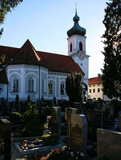 Saint Agatha Church | |
 Coat of arms | |
Location of Maitenbeth within Mühldorf am Inn district 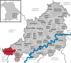 | |
 Maitenbeth  Maitenbeth | |
| Coordinates: 48°09′00″N 12°05′30″E | |
| Country | Germany |
| State | Bavaria |
| Admin. region | Oberbayern |
| District | Mühldorf am Inn |
| Municipal assoc. | Maitenbeth |
| Subdivisions | 58 Ortsteile |
| Government | |
| • Mayor | Josef Kirchmaier (FW) |
| Area | |
| • Total | 30.94 km2 (11.95 sq mi) |
| Elevation | 609 m (1,998 ft) |
| Population (2018-12-31)[1] | |
| • Total | 2,029 |
| • Density | 66/km2 (170/sq mi) |
| Time zone | CET/CEST (UTC+1/+2) |
| Postal codes | 83558 |
| Dialling codes | 08076 |
| Vehicle registration | MÜ |
| Website | www.maitenbeth.de |
Maitenbeth consists of 58 official communes.:[2]
|
|
|
|
References
- "Fortschreibung des Bevölkerungsstandes". Bayerisches Landesamt für Statistik und Datenverarbeitung (in German). July 2019.
- http://www.bayerische-landesbibliothek-online.de/orte/ortssuche_action.html?anzeige=voll&modus=automat&tempus=+20120104/130243&attr=OBJ&val=405
| Authority control |
|
|---|
This article is issued from Wikipedia. The text is licensed under Creative Commons - Attribution - Sharealike. Additional terms may apply for the media files.