Maine State Route 125
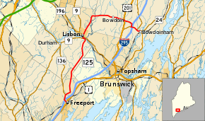
State Route 125 (SR 125) is a north-south route in the U.S. State of Maine that runs between the towns of Freeport and Bowdoinham, passing through Lisbon Falls.[2]
| ||||
|---|---|---|---|---|
 | ||||
| Route information | ||||
| Maintained by MaineDOT | ||||
| Length | 22.16 mi[1] (35.66 km) | |||
| Major junctions | ||||
| South end | ||||
| ||||
| North end | ||||
| Location | ||||
| Counties | Cumberland, Androscoggin, Sagadahoc | |||
| Highway system | ||||
| ||||

Major intersections
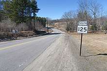
Signage for SR 125 in Bowdoin
| County | Location[3] | mi[1] | km | Destinations | Notes |
|---|---|---|---|---|---|
| Cumberland | Freeport | 0.00 | 0.00 | Southern terminus of SR 136 | |
| 0.34– 0.55 | 0.55– 0.89 | Exit 22 (I-295) | |||
| 1.27 | 2.04 | Northern end of concurrency with SR 136 | |||
| Androscoggin | Durham | 10.54 | 16.96 | Southern end of concurrency with SR 9 | |
| Lisbon | 10.89 | 17.53 | Northern end of concurrency with SR 9 | ||
| Sagadahoc | Bowdoin | 18.83 | 30.30 | Southern end of concurrency with US 201 | |
| 18.92 | 30.45 | Northern end of concurrency with US 201 | |||
| Bowdoinham | 20.57 | 33.10 | Southern end of concurrency with SR 138 | ||
| 20.63– 20.81 | 33.20– 33.49 | Exit 37 (I-295) | |||
| 21.50 | 34.60 | Northern end of concurrency with SR 138 | |||
| 22.16 | 35.66 | ||||
1.000 mi = 1.609 km; 1.000 km = 0.621 mi
| |||||
References
- Maine DOT Map Viewer (Map). Maine Office of GIS. Retrieved October 14, 2017.
- Google (August 17, 2016). "Driving Directions" (Map). Google Maps. Google. Retrieved August 17, 2016.
- DeLorme (2011). "Map 6" (Map). The Maine Atlas and Gazetteer (32nd ed.). Yarmouth, ME: DeLorme.
External links

- Floodgap Roadgap's RoadsAroundME: Maine State Route 125
This article is issued from Wikipedia. The text is licensed under Creative Commons - Attribution - Sharealike. Additional terms may apply for the media files.