Maine State Route 195
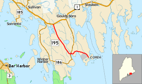
State Route 195 (SR 195) is part of Maine's system of numbered state highways. It runs entirely in the town of Gouldsboro for a length of 8.09 miles (13.02 km). It travels from an intersection with Corea Road and Crowley Island Road in Corea to an intersection with U.S. Route 1 (US 1).[2]
| ||||
|---|---|---|---|---|
 | ||||
| Route information | ||||
| Maintained by MaineDOT | ||||
| Length | 8.09 mi[1] (13.02 km) | |||
| Existed | 1925–present | |||
| Major junctions | ||||
| South end | Crowley Island Road in Gouldsboro | |||
| North end | ||||
| Location | ||||
| Counties | Hancock | |||
| Highway system | ||||
| ||||

The route is notable due to not being renumbered or decommissioned after the Interstate Highway System was installed, as was the case with State Route 95.[3]
Major junctions
The entire route is in Gouldsboro, Hancock County.
| mi[1] | km | Destinations | Notes | ||
|---|---|---|---|---|---|
| 0.00 | 0.00 | Corea Road / Crowley Island Road | |||
| 3.06 | 4.92 | Southern end of SR 186 concurrency | |||
| 3.20 | 5.15 | Northern end of SR 186 concurrency | |||
| 8.09 | 13.02 | ||||
1.000 mi = 1.609 km; 1.000 km = 0.621 mi
| |||||
References
- "Maine DOT Map Viewer". Maine Office of GIS. Retrieved August 31, 2017.
- Google (August 31, 2017). "Maine State Route 195" (Map). Google Maps. Google. Retrieved August 31, 2017.
- Floodgap Roadgap's RoadsAroundME: Maine State Route 195 Archived 2011-06-12 at Archive.today
External links
This article is issued from Wikipedia. The text is licensed under Creative Commons - Attribution - Sharealike. Additional terms may apply for the media files.