Maine State Route 193
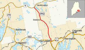
State Route 193 (SR 193) is part of Maine's system of numbered state highways. It runs 19.08 miles (30.71 km) from an intersection at U.S. Route 1 (US 1) in Cherryfield to rural East Hancock, Hancock County at State Route 9 near Beddington. SR 193 originally ran between East Eddington and East Holden. The original route was renumbered SR 175, and 193 was moved to its current location. The new route originally ran closer to Beddington Lake, but the road was not suitable for heavy traffic, and a new connector to its current terminus was built in 1956.[2] The northern terminus is just south of Lead Mountain.[3]
| ||||
|---|---|---|---|---|
 | ||||
| Route information | ||||
| Maintained by MaineDOT | ||||
| Length | 19.08 mi[1] (30.71 km) | |||
| Existed | 1925–present | |||
| Major junctions | ||||
| South end | ||||
| North end | ||||
| Location | ||||
| Counties | Washington, Hancock | |||
| Highway system | ||||
| ||||

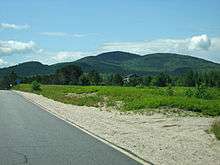
View of Lead Mountain from Route 193
Major junctions
| County | Location | mi[1] | km | Destinations | Notes |
|---|---|---|---|---|---|
| Washington | Cherryfield | 0.00 | 0.00 | ||
| Hancock | East Hancock | 19.08 | 30.71 | ||
| 1.000 mi = 1.609 km; 1.000 km = 0.621 mi | |||||
References
- "Maine DOT Map Viewer". Maine Office of GIS. Retrieved August 30, 2017.
- Floodgap Roadgap's RoadsAroundME: Maine State Route 193 Archived 2011-06-12 at Archive.today
- Google (August 30, 2017). "Maine State Route 193" (Map). Google Maps. Google. Retrieved August 30, 2017.
External links
This article is issued from Wikipedia. The text is licensed under Creative Commons - Attribution - Sharealike. Additional terms may apply for the media files.