Maekelay Zone
Maekelay ("Central") is a Zone in the Ethiopian Region of Tigray. Maekelay zone is bordered on the east by Misraqawi (Eastern), on the south by Debub Misraqawi (South Eastern), on the west by Semien Mi'irabawi (North Western) and on the north by Eritrea. Towns and cities in Mehakelegnaw include Axum and Adwa, as well as the historically significant village of Yeha and the town of Tembien Abiyi Adi.
Central Tigray ማዕኸላይ ዞን | |
|---|---|
Zone | |
 Flag | |
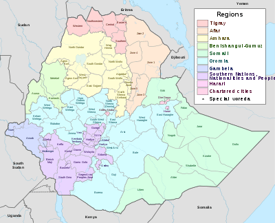
 Central Tigray location in Ethiopia | |
| Country | Ethiopia |
| Region | Tigray Region |
| Largest city | Axum |
| Area | |
| • Total | 22,133.87 km2 (8,545.93 sq mi) |
| Population (2012 est.) | |
| • Total | 1,412,339 |
| • Density | 64/km2 (170/sq mi) |
Demographics
Based on the 2007 Census conducted by the Central Statistical Agency of Ethiopia (CSA), this Zone has a total population of 1,245,824, of whom 613,797 are men and 632,027 women; 176,453 or 14.16% are urban inhabitants. The largest ethnic group reported in Mehakelegnaw was the Tigrayan (99.37%); all other ethnic groups made up 0.63% of the population. Tigrinya is spoken as a first language by 99.4; the remaining 0.6% spoke all other primary languages reported. 97.82% of the population said they were Orthodox Christians, and 2.07% were Muslim.[2]
The 1994 national census reported a total population for the Mehakelegnaw Zone of 943,850, of whom 464,633 were men and 479,217 women; 91,058 or 9.6% of its population were urban dwellers. The Zone is predominantly Tigrayan, at 99.6% of the population, while 0.11% were Agaw, 0.096% Amhara, and all other ethnic groups 0.12%. Tigrinya was spoken as a first language by 99.67% of the inhabitants. 98.41% of the population said they were Orthodox Christians, and 1.55% were Muslim. Concerning education in the Zone, 9.64% of the population were considered literate; 10.62% of children aged 7–12 were in primary school, while a negligible number of the children aged 13–14 were in junior secondary school, and 0.14% of children aged 15–18 were in senior secondary school. Concerning sanitary conditions, about 25% of the urban and 5.6% of all houses had access to safe drinking water at the time of the census; about 2.5% of the urban and 6% of the total had toilet facilities.[3]
According to a May 24, 2004 World Bank memorandum, 13% of the inhabitants of Mehakelegnaw have access to electricity, this zone has a road density of 29.0 kilometers per 1000 square kilometers, the average rural household has 0.8 hectare of land (compared to the national average of 1.01 hectare of land and a regional average of 0.51)[4] and the equivalent of 0.8 heads of livestock. 17% of the population is in non-farm related jobs, compared to the national average of 25% and a regional average of 28%. 74% of all eligible children are enrolled in primary school, and 28% in secondary schools. 78% of the zone is exposed to malaria, and none to Tsetse fly. The memorandum gave this zone a drought risk rating of 616.[5]
The decline of Tigrayan ethnic population in Ethiopia (and in present-day districts like Addi Arkay (woreda), Kobo (woreda) & Sanja (woreda)), during Haile Selassie's rule is likely to have been his immense oppression & systematic prosecution against non-Amhara ethnic people of Ethiopia (in particular, his immense systematic prosecution of Tigrayans). For example, on the 1958 Tigray famine, Haile Selassie refused to send basic emergency food aid to Tigray province even though he had the money; so in consequence over 100,000 people died of the famine (in Tigray province).[6][7][8]
Later on, the Mengistu Haile Mariam-led military dictatorship (Derg) also used the 1983–1985 famine in Ethiopia as government policy (by restricting food supplies) for counter-insurgency strategy, and for "social transformation" in non-insurgent areas (against people of Tigray province, Wello province and so on).[9][10][11] Due to organized government policies that deliberately multiplied the effects of the famine, around 1.2 million people died in Ethiopia from this famine where majority of the death tolls were from Tigray province (and other parts of northern Ethiopia).[12][13][14]
Notes
- Geohive: Ethiopia Archived 2012-08-05 at the Wayback Machine
- Census 2007 Tables: Tigray Region Archived November 14, 2010, at the Wayback Machine, Tables 2.1, 3.1, 3.2, 3.4.
- The 1994 Population and Housing Census of Ethiopia: Tigray Region Archived December 7, 2008, at the Wayback Machine, vol. 1, part 1: Tables 2.1, 2.11, 2.14
- Comparative national and regional figures comes from another World Bank publication, Klaus Deininger et al. "Tenure Security and Land Related Investment", WP-2991 Archived 2007-03-10 at the Wayback Machine (accessed 23 March 2006).
- World Bank, Four Ethiopias: A Regional Characterization (accessed 23 March 2006).
- "Bahru Zewde, [London: James Currey, 1991], p. 196. "A History of Modern Ethiopia: 1855–1974"".
- "Peter Gill, p.26 & p.27. "Famine and Foreigners: Ethiopia Since Live Aid"" (PDF). Archived from the original (PDF) on 2018-05-16. Retrieved 2019-03-03.
- "Mesfin Wolde Mariam, "Rural Vulnerability to Famine in Ethiopia: 1958-77"".
- de Waal 1991, p. 4–6.
- Young 2006, p. 132.
- "Peter Gill, p.43 "Famine and Foreigners: Ethiopia Since Live Aid"" (PDF). Archived from the original (PDF) on 2018-05-16. Retrieved 2019-03-03.
- "Peter Gill, page.44 "Famine and Foreigners: Ethiopia Since Live Aid"" (PDF). Archived from the original (PDF) on 2018-05-16. Retrieved 2019-03-03.
- "Dawit Wolde Giorgis, "Red Tears: War, Famine, and Revolution in Ethiopia"".
- de Waal 1991, p. 5.
Zones of the Tigray Region | ||
|---|---|---|
| | |
Woredas of the Mehakelegnaw Zone | ||
|---|---|---|
| ||