Madeira Beach, Florida
Madeira Beach (/məˈdɛərə/ mə-DAIR-ə) is a city in Pinellas County, Florida, United States, bordered on the west by the Gulf of Mexico and on the east by St. Petersburg. As of the 2010 census, the population was 4,263.[5] The area is primarily residential with little or no industrial or sizable service businesses. Residents are mostly supported by commercial interests outside the area, and many residents are retirees. Entertainment district John's Pass is located on the Intracoastal Waterway. The city is often referred to by locals as Mad Beach.[6]
Madeira Beach, Florida | |
|---|---|
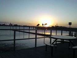 Sunset at Madeira Beach | |
| Nickname(s): Two miles long and a smile wide | |
 Location in Pinellas County and the state of Florida | |
| Coordinates: 27°47′45″N 82°47′26″W | |
| Country | |
| State | |
| County | Pinellas |
| Area | |
| • Total | 3.26 sq mi (8.45 km2) |
| • Land | 0.98 sq mi (2.55 km2) |
| • Water | 2.28 sq mi (5.90 km2) |
| Elevation | 3 ft (1 m) |
| Population (2010) | |
| • Total | 4,263 |
| • Estimate (2018)[2] | 4,327 |
| • Density | 4,483.74/sq mi (1,731.02/km2) |
| Time zone | UTC-5 (Eastern (EST)) |
| • Summer (DST) | UTC-4 (EDT) |
| ZIP codes | 33708, 33738 |
| Area code(s) | 727 |
| FIPS code | 12-42400[3] |
| GNIS feature ID | 0286267[4] |
| Website | www |
Geography
Madeira Beach is located at 27°47′45″N 82°47′26″W.[7]
According to the United States Census Bureau, the city has a total area of 3.3 square miles (8.5 km2), of which 1.0 square mile (2.6 km2) is land and 2.2 square miles (5.7 km2) (68.50%) is water.[8] The city is located on a barrier island between the Gulf of Mexico to the southwest and Boca Ciega Bay to the northeast. One bridge, the Tom Stuart Causeway, connects Madeira Beach to the mainland, in the unincorporated community of Bay Pines. To the northwest of Madeira Beach is the town of Redington Beach, and to the southeast, across the inlet of John's Pass, is the city of Treasure Island.
Demographics

| Historical population | |||
|---|---|---|---|
| Census | Pop. | %± | |
| 1950 | 916 | — | |
| 1960 | 3,943 | 330.5% | |
| 1970 | 4,177 | 5.9% | |
| 1980 | 4,520 | 8.2% | |
| 1990 | 4,225 | −6.5% | |
| 2000 | 4,511 | 6.8% | |
| 2010 | 4,263 | −5.5% | |
| Est. 2018 | 4,327 | [2] | 1.5% |
| U.S. Decennial Census[9] | |||
At the 2000 census there were 4,511 people in 2,528 households, including 1,122 families, in the city. The population density was 4,392.0 per square mile (1,691.0/km²). There were 3,976 housing units at an average density of 3,871.1 per square mile (1,490.4/km²). The racial makeup of the city was 97.05% White, 0.27% African American, 0.31% Native American, 0.58% Asian, 0.04% Pacific Islander, 0.67% from other races, and 1.09% from two or more races. Hispanic or Latino of any race were 2.37%.[3]
Of the 2,528 households 9.1% had children under the age of 18 living with them, 35.6% were married couples living together, 5.6% had a female householder with no husband present, and 55.6% were non-families. 42.4% of households were one person and 12.2% were one person aged 65 or older. The average household size was 1.78 and the average family size was 2.36.
The age distribution was 8.2% under the age of 18, 4.8% from 18 to 24, 29.3% from 25 to 44, 35.7% from 45 to 64, and 22.0% 65 or older. The median age was 48 years. For every 100 females, there were 111.3 males. For every 100 females age 18 and over, there were 110.2 males.
The median household income was $36,671 and the median family income was $50,833. Males had a median income of $32,353 versus $27,455 for females. The per capita income for the city was $30,097. About 4.1% of families and 9.8% of the population were below the poverty line, including 4.1% of those under age 18 and 12.2% of those age 65 or over.
See also
References
- "2016 U.S. Gazetteer Files". United States Census Bureau. Retrieved July 7, 2017.
- "Population and Housing Unit Estimates". Retrieved October 14, 2019.
- "U.S. Census website". United States Census Bureau. Retrieved January 31, 2008.
- "US Board on Geographic Names". United States Geological Survey. October 25, 2007. Retrieved January 31, 2008.
- "Profile of General Population and Housing Characteristics: 2010 Demographic Profile Data (DP-1): Madeira Beach city, Florida". United States Census Bureau. Retrieved May 7, 2012.
- "US Gazetteer files: 2010, 2000, and 1990". United States Census Bureau. February 12, 2011. Retrieved April 23, 2011.
- "Geographic Identifiers: 2010 Demographic Profile Data (G001): Madeira Beach city, Florida". United States Census Bureau. Retrieved May 7, 2012.
- "Census of Population and Housing". Census.gov. Retrieved June 4, 2015.
External links
Municipalities and communities of Pinellas County, Florida, United States | ||
|---|---|---|
| Cities | 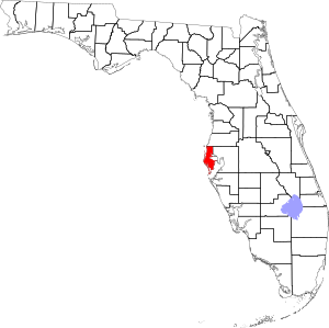 | |
| Towns | ||
| CDPs | ||
| Unincorporated communities | ||
| Authority control |
|
|---|