Machala
Machala (Spanish pronunciation: [maˈtʃala]) is a city in south-west Ecuador. It is the capital of the El Oro Province, and is located near the Gulf of Guayaquil on fertile lowlands. Machala has a population of 241,606 (2010 census); it is the fourth-biggest city in the country, and the second-most important port. It has been referred to as the Banana Capital of the World.
Machala | |
|---|---|
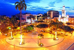 View of Juan Montalvo Park (Parque Juan Montalvo) and Machala Cathedral | |
 Flag | |
| Nickname(s): La tierra del Salitroso | |
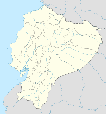 Machala Location of Machala in Ecuador | |
| Coordinates: 3°16′S 79°58′W | |
| Country | |
| Province | El Oro |
| Canton | Machala |
| Founded | 1573 |
| Government | |
| • Mayor | Carlos Falquez Batallas |
| Area | |
| • City | 207.09 km2 (79.96 sq mi) |
| • Metro | 330.18 km2 (127.48 sq mi) |
| Elevation | 6 m (20 ft) |
| Population (2010) | |
| • City | 241,606 |
| • Density | 1,200/km2 (3,000/sq mi) |
| • Metro | 245,972 |
| Demonym(s) | Machaleño / a |
| Time zone | UTC-5 (ECT) |
| Area code(s) | (+593) 7 |
| Website | www.machala.gob.ec (in Spanish) |
Economy
Machala is a commercial center for the surrounding agriculture industries. There is a large trade in bananas, coffee and cocoa. The banana industry is especially oriented for exportation, and plays a huge role in the city's economy. Bananas are shipped out from nearby Puerto Bolívar mainly to North America. Machala's geographical position near Guayaquil also makes it an important transportation center. Many travelers heading south to Peru or north to Guayaquil funnel through the city. It is not known as a tourist destination among Ecuadorians or international tourists, though its proximity to the Pacific Ocean positions it close to beaches. Machala has a growing economy that was marked in 2007 by the inauguration of its first mall, with a movie theater, on the outskirts of the city.
Orientation
The center of Machala is dominated by a large Catholic church and a central plaza. The plaza was built in the early 2000s to include a large fountain. There are many hotels situated in the center of the city. Las Brisas, located nearly a mile from the central plaza, is another popular place in Machala; it is a wealthier neighborhood which used to serve as a popular hangout for local teenagers. But the remodeling of La Zona Rosa, as well as the decreased safety of the area, have led to its becoming less popular.
Education
Machala has one university, the Universidad Técnica de Machala. There are many private schools in Machala and one public high school – Colegio 9 de Octubre. The city serves as a stopping-off point on the way to nearby Puerto Bolívar and the Jambelí Islands, which can only be reached by ferry.
Climate
Machala features a steppe climate (BSh) under Köppen climate classification.
| Climate data for Machala | |||||||||||||
|---|---|---|---|---|---|---|---|---|---|---|---|---|---|
| Month | Jan | Feb | Mar | Apr | May | Jun | Jul | Aug | Sep | Oct | Nov | Dec | Year |
| Average high °C (°F) | 30.4 (86.7) |
30.9 (87.6) |
31.0 (87.8) |
31.1 (88.0) |
29.8 (85.6) |
27.8 (82.0) |
27.0 (80.6) |
26.6 (79.9) |
27.0 (80.6) |
26.9 (80.4) |
28.0 (82.4) |
29.7 (85.5) |
28.9 (83.9) |
| Average low °C (°F) | 22.6 (72.7) |
22.8 (73.0) |
22.9 (73.2) |
23.1 (73.6) |
22.7 (72.9) |
21.5 (70.7) |
20.8 (69.4) |
20.1 (68.2) |
20.2 (68.4) |
20.7 (69.3) |
21.0 (69.8) |
21.8 (71.2) |
21.7 (71.0) |
| Average rainfall mm (inches) | 71 (2.8) |
111 (4.4) |
116 (4.6) |
69 (2.7) |
24 (0.9) |
14 (0.6) |
12 (0.5) |
11 (0.4) |
11 (0.4) |
16 (0.6) |
13 (0.5) |
21 (0.8) |
489 (19.2) |
| Source: Climate Data | |||||||||||||
Transportation
Air
Santa Rosa International Airport (IATA: ETR, ICAO: SERO) serves as the city's principal airport. It hosts commercial flights to Quito with the Ecuadorian airline TAME.
Notable residents
- Gabriel Achilier (born 1985), footballer[1]
- Gilberto Chamba, serial killer
- Fausto Tutu Guzman (born 1944), great Basketball player and Pajero Professional
- Nicolás Asencio (born 1975), footballer
- Juan Carlos Espinoza Mercado (born 1987), footballer
- Ángel Fernández (born 1971), footballer
- Luis Miguel Garcés (born 1982), footballer
- Hólger Matamoros (born 1985), footballer
- Carlos Muñoz (1964–1993), footballer
- Ismael Pérez Pazmiño (1876–1944), journalist and politician[2]
- Ángel Pután (born 1986), footballer
- Tania Tinoco (born 1963), journalist and television producer[3]
References
- "Fallece esposa de Gabriel Achilier" [Gabriel Achilier's Wife Dies]. La Hora (in Spanish). January 23, 2017. Retrieved September 12, 2017.
- "Ismael Pérez Pazmiño". diccionariobiograficoecuador.com (in Spanish). Retrieved September 12, 2017.
- Pezo, Claudia (August 31, 2003). "Tania Tinoco: Mi familia es lo primero" [Tania Tinoco: My Family Comes First]. El Universo (in Spanish). Retrieved September 12, 2017.
External links
| Wikimedia Commons has media related to Machala. |
- Official website

- Orenses - El Oro - Machala - Ecuador / Comunidad Virtual de la Provincia de El Oro News about Machala in Spanish
- Chat Orenses - El Oro - Machala - Ecuador Chat Orenses - El Oro - Machala - Ecuador
- Investor info for Ecuador and Machala
- Universidad Technica de Machala
- Sitio informativo de la Capital Bananera del Mundo
- Ecuador, Travel in Machala
Provincial capitals in Ecuador | ||
|---|---|---|
Within regions, north to south | ||
| Insular |  | |
| Costa | ||
| Sierra | ||
| Oriente | ||