Lycian Way
The Lycian Way (Turkish: Likya Yolu) is a marked long-distance trail in southwestern Turkey around part of the coast of ancient Lycia.[1] It is over 500 km (310 mi) in length and stretches from Hisarönü (Ovacık), near Fethiye, to Geyikbayırı in Konyaaltı about 20 km (12 mi) from Antalya. It is waymarked with red and white stripes of the Grande Randonnee convention. It was conceived by Briton Kate Clow, who lives in Turkey.[2] It takes its name from the ancient civilization, which once ruled the area.[3]
| Lycian Way | |
|---|---|
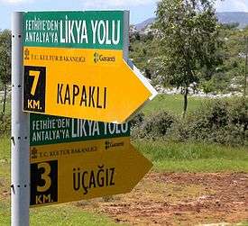 Yellow direction signs on the Lycian Way. | |
| Length | Over 500 km (310 mi) |
| Location | Teke Peninsula, southwestern Turkey |
| Established | 1999 |
| Trailheads | Hisarönü (Ovacık, Fethiye), Muğla Province Geyikbayırı, Konyaaltı, Antalya Province |
| Use | Hiking |
| Hiking details | |
| Season | Spring and autumn |
| Trail map | |
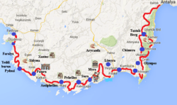 Map of Lycian Way at Teke Peninsula. | |
History
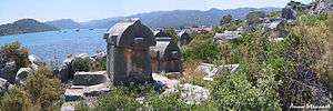
Lycia was a region on the Western Taurus Mountains in Teke Peninsula at southwestern Anatolia on the Mediterranean Sea coast, located in what are today the provinces Muğla and Antalya. According to historians, Lycian people lived in the prehistoric Late Bronze Age.[2] They built city-states along the Mediterranean Sea coast such as Xanthos, Patara, Myra, Pinara, Tlos, Olympos and Phaselis,[2] and formed the Lycian League. Thanks to their strategic location, they had best opportunities for sea trade and even piracy.[4] In later times, the region of Lycia was occupied by the Persian Empire, Ancient Greece, and then controlled by Ancient Rome, Byzantine Empire, Seljuk Empire, and finally the Ottoman Empire.[4] Rock-cut tombs on cliff walls and sarcophagi in the region testify to the Lycian civilization.[3]
The Lycian Way, used by the Lycians as a footpath and mule trail, was conceived by Kate Clow, a British expatriate living in Turkey since 1989, and opened in 1999.[2][4][3] The Garanti Bank sponsored the waymarking that was carried out by a group of volunteers organized by Clow.[2][3]
Trail


The Lycian Way, named after the Lycian civilization that ruled in this region,[3] is over 500 km (310 mi) in length, stretching from Hisarönü (Ovacık) in the Fethiye district of Muğla Province in the west to Geyikbayırı in the Konyaaltı district in Antalya Province in the east. The long-distance trail is waymarked after the French Grande Randonnée special system, and the intersections are marked with yellow directional signs.[1][5] The trails are marked on both sides of rocks and tree trunks at every 50 m (160 ft), and the dirt roads at about 200 m (660 ft) along the route, especially at places like forks or crossroads, with signs of a white stripe above a red stripe. Red-cross marks indicate a deviation from the path, and that the marked trail should not be entered. The signs are periodically renewed by volunteers.[5]
Some parts of the Lycian Way are suitable for trail riding with mountain bikes. In some places, experienced downhill and single-track enthusiasts can pass the entire track by carrying the bike on the back. However, it is also possible to try the bicycle route, which is partly on the Lycian Way and on parallel side roads, by using alternative forest and village roads.[5]
Clow wrote a guidebook[4] in which the characteristics of the trail, such as the width of the path, the kinds of waymarks, and the distance and hiking time of the stages, are described.[3]
Climate
The region has hot, dry summers and mild winters with low annual rainfall due to the prevailing Mediterranean climate. The hiking season is long; however, the best time is the spring season, when the hills are still snow covered and the landscape is covered with flowers. The months of October and November in the autumn season also offer enjoyable hiking as the heat and humidity decrease gradually. At higher elevations and on the mountain peaks, weather reminiscent of all four seasons can be experienced in one day.[5] Low-elevation areas are quite hot for hiking activity in mid-May and mid-September. Rain and storms can be experienced in December and January. From January to early April, there is usually snow at elevations over 1,500 m (4,900 ft). Between November and February, downpours can occur.[5]
Equipment

The recommended equipment required for hiking in the Lycian Way consists of soft-soled, ankle-grasping, waterproof-breathable fabric hiking boots, quick-drying pants and socks, moisture-wicking fabric shirts, headgear, cheesecloth for covering the neck, raincoat, spare clothes and underwear, sunglasses, sunscreen, and a backpack. It is also useful to have a swimsuit and towel.[5]
Other useful equipment includes compass, trail map, whistle, pocket knife, headlight, camera, lighter, spare battery, a small first-aid kit, and a mobile phone.[5]
Stages
The Lycian Way can be hiked in stages like Hisarönü (Ovacık)-Faralya, Faralya-Kabak Bay, Kabak Bay-Alınca, Alınca-Yediburunlar, Yediburunlar-Gavurağılı, Gavurağılı-Patara, Patara-Kalkan, Kalkan-Sarıbelen-Gökçeören, Gökçeören-Kaş, Kaş-Kekova, Kekova-Demre, Demre-Alakilise-Finike, Karaöz-Cape Gelidonya-Adrasan, Adrasan-Olimpos-Çıralı, Çıralı-Beycik, Çıralı-Tekirova, Tekirova-Phaselis-Gedelme, Beycik-Tahtalı Dağı-Gedelme, Gedelme-Göynük, Göynük-Hisarçandır, and Hisarçandır-Geyikbayırı.[5]
The trail splits into:[6]
- Coastal route – Tekirova, Phaselis, Asagikuzdere, Goynuk Yaylasi, Hısarçandır, Çitdibi, Geyikbayırı
- Inland route – Ulupınar, Beycik, Yukari Beycik, pass over Tahtalı Dağı at 1800m, Yayla Kuzdere, Gedelme, Goynuk Yaylasi, where it joins the coastal trail.
Places of interest

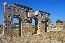

Places of interest along the trail include: Ölüdeniz, Butterfly Valley, Faralya, Kabak Bay, Cennet Bay, Korsan Bay, Letoon (historical capital of the Lycian region, a UNESCO World Heritage Site in Seydikemer), Sidyma, Bel, Gavurağılı, Letoon, Kınık (Xanthos), Akbel, Gelemiş village and ruins of Patara (the Lycian capital), Kalkan, Sarıbelen, Gökçeören, Kaş (Antiphellos), Üçağız, Kale, Demre (Myra), Kumluca, Belören, Zeytin and Alakilise, İncegeriş Hill ( 1,811 m (5,942 ft) AMSL) , Belos, Finike, Kumluca, Mavikent, Karaöz, the lighthouse of Cape Gelidonya (the southernmost point of Lycia), Adrasan, Olympos, and Çıralı.[4][6]
Further, the ancient cities Pydnae, Apelia, Telmessos, Idyros, Antiphellus, Apollonia, and Simena can be found between Xanthos and Patara.[4]
Access and lodging
The starting points of the Lycian Way can be reached in the west from the Dalaman Airport or in the east from the Antalya Airport. Intercity coaches and local buses are available for transportation to the starting points.[3][5]
Lodging is offered in hotels, motels, and bed and breakfast (B&B) suitable for all budgets in locations[3] such as Fethiye, Ölüdeniz, Faralya, Kabak Bay, Patara, Kalkan, Kaş, Kekova, Demre, Finike, Adrasan, Olympos, Çıralı, Tekirova, Çamyuva, Kemer, and Göynük. In some villages along the route, additional accommodation options have emerged in recent years by using traditional village houses as B&B. Natural camping sites and camping facilities are also available on the route. Campsites in Kabak Bay, Patara, Özlen Çay, Warm Peninsula, Andriake (Çayağzı Port), Olympos, Çıralı, and Göynük are recommended.[5]
Ultramarathon
Since 2010, an international multiday trail running ultramarathon, called the Lycian Way Ultramarathon, is held on the historical trail. The event runs eastwards on a route of around 220–240 km (140–150 mi) from Ölüdeniz to Antalya in six days.[5][7][8]
See also
| Wikimedia Commons has media related to Lycian Way. |
References
- "Lycian Way". Culture Routes Society. Retrieved 18 June 2020.
- "'Az gittik, uz gittik' sözünün doğruluğunu bu yollarda anladık" [In these ways we understood the truth of the word 'we went little, we went long']. Hürriyet (in Turkish). 1 May 2006. Retrieved 15 May 2020.
- Whitman Piper, Ernest (8 July 2017). "Lycian Way: Hike through the best trekking route in Turkey". Daily Sabah. Retrieved 17 May 2020.
- "Following the path of the ancients, the Lycian Way offers history, adventure and more". Daily Sabah. 5 May 2018. Retrieved 17 May 2020.
- "Likya Yolu yürüyüşü – Dünyanın en güzel yürüyüş rotası" [Lycian Way walk – The most beautiful walking route in the world] (in Turkish). momondo. 4 January 2019. Retrieved 16 May 2020.
- Kate Clow – The Lycian Way 4th edition, June 2014
- "Rota" [Route] (in Turkish). Likya Yolu Ultramaratonu. Retrieved 27 November 2013.
- "Hakkında" [About] (in Turkish). Likya Yolu Ultramaratonu. Retrieved 27 November 2013.
External links
- Reference database and GPS apps for The Lycian Way.
- Turkey's Lycian Way Trip report of a 2011 thru-hike on the Lycian Way
- Trekking guide books and Trekking in Turkey information point
- The site of the Culture Routes Society, which manages the path
- Lycian Way Paths, pics ve GPS records: English/Turkish site
- Lycian Turkey

- Lycian Way Ultramarathon
- Lycian Way supported treks
- Tüzün, Metin (May 2019). Likya Yolu Rehberi (in Turkish). Istanbul: Elpis Yayınları. ISBN 978-605-764-7184.