Lusaka–Livingstone Road
The Lusaka–Livingstone Road or Livingstone Road is the main highway of the Southern Province of Zambia. From Lusaka city centre, to the principal tourist destination, Livingstone, Southern Africa, measuring approximately 485 kilometres (301 mi).[1] The first 64 kilometres (40 mi), from Lusaka to Kafue Weighbridge, is part of the T2 Road.[2] From Kafue Weighbridge to Livingstone and continuing to the Victoria Falls is designated as the T1 Road and is part of Trans-African Highway network number 4 or Cairo–Cape Town Highway between Cairo and Cape Town.[3]
| Lusaka-Livingstone road | |
|---|---|
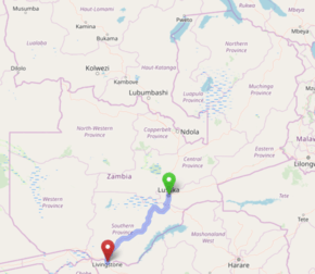 Map showing the Lusaka-Livingstone road through Zambia | |
| Route information | |
| Length | 485 km (301 mi) |
| Major junctions | |
| North-east end | Lusaka |
| T2 South of Kafue M11 in Choma M10 in Livingstone | |
| South-west end | Livingstone, Zambia |
| Highway system | |
| Transport in Zambia | |
Location
The highway starts in Lusaka, the capital of Zambia, and follows a general south-westerly direction through Lusaka District, Chilanga District, Kafue District, Mazabuka District, Monze District, Choma District, Kalomo District, Kazungula District, Zimba District, to end in Livingstone District. It is a magnificent scenic road with views throughout.[4]
Route
The total distance from Lusaka to Livingstone is approximately 485 kilometres (301 mi).[1]
T2 Road
The Lusaka-Livingstone Road starts in Lusaka, the capital city, as part of Zambia's Great North Road (T2 Road). It goes southwards as Kafue Road for 60 kilometres (37 mi), through Chilanga and Kafue, to cross the Kafue River into the Southern Province.
It enters the Chikankata District of Southern Province and reaches a junction with the T1 Road just after the Kafue River crossing. As the T2 continues to the Chirundu border with Zimbabwe, the Lusaka-Livingstone Road leaves the T2 Road and becomes the T1 Road westwards.
T1 Road
From the T2 Road t-junction, the T1 goes westwards for 68 kilometres (42 mi) to the town of Mazabuka. It enters Mazabuka in a northerly direction. By ABSA Bank, the T1 turns westwards and by Mazabuka Police Station, the T1 turns northwards. It is one road for the remainder of its length to Livingstone.
North of Mazabuka town centre, the road turns west and then south west. It goes for 60 kilometres (37 mi), through the settlement of Magoye, to the town of Monze. After passing through Monze in a southerly direction, it continues for 35 kilometres (22 mi), through the small town of Chisekesi (where it meets a road going to Gwembe), to the town of Pemba.
From Pemba, the T1 goes south-west for 60 kilometres (37 mi), through the settlement of Batoka, to the city of Choma, Southern Province's Capital since 2012. In Choma, the T1 meets the M11 Road, which connects Choma with Namwala and the Itezhi-Tezhi Dam. It also meets a road (D356) connecting southwards to Sinazongwe by Lake Kariba.
From Choma, the T1 goes west-south-west for 60 kilometres (37 mi) to the town of Kalomo, which was the first capital city of the former North-Western Rhodesia. In Kalomo, the T1 meets a road which accesses the southern part of the Kafue National Park.
From Kalomo, the road goes south-west for 50 kilometres (31 mi) to the market town of Zimba. From Zimba, the road continues south-south-west for 80 kilometres (50 mi), through a narrow part of Kazungula District, to the city of Livingstone, Zambia's tourist capital.
South of Livingstone City Centre, the T1 Road meets the M10 Road, which connects Livingstone with Kazungula (Botswana Border Post), Sesheke (Namibia Border Post) and Mongu. This marks the end of the Lusaka-Livingstone Road.
The T1 continues southwards for another 10 kilometres (6 mi) to the Victoria Falls, where it crosses the Zambezi River via the Victoria Falls Bridge into the Republic of Zimbabwe, where it becomes the A8 Road to Bulawayo. The town on the other side of the Zambezi River crossing is also named Victoria Falls.
Road Network
This road, between Lusaka and Livingstone is part of Trans-African Highway number 4 or Cairo-Cape Town Highway, which links Cairo in Egypt with Gaborone in Botswana and Cape Town in South Africa.[3]
It is also part of the route that motorists and heavy cargo trucks from Botswana, Namibia and parts of South Africa use to reach Lusaka, Zambia's capital city. From Lusaka, this traffic continues to the north and east, including Tanzania, Malawi and the Democratic Republic of the Congo.[5]
As a result, the road may be very busy and occupied with trucks, cars and buses, in either direction. As the road is one lane in each direction, heavy traffic and traffic jams are common.[6]
References
- Google (11 May 2020). "Distance Between Lusaka And Livingstone, In Zambia" (Map). Google Maps. Google. Retrieved 11 May 2020.
- Google (11 May 2020). "Distance Between Lusaka And Kafue Weighbridge In Zambia" (Map). Google Maps. Google. Retrieved 11 May 2020.
- Eleanor Whitehead (29 May 2014). "Trans-African Highway Remains A Road To Nowhere". Howwemadeitinafrica.com. Retrieved 11 May 2020.
- Winnie Rioba (11 May 2020). "How To Travel From Zambia to Zimbabwe By Road". Justrioba.com. Retrieved 11 May 2020.
- Millicent Kgeledi (6 March 2017). "Towards effortlessly moving people and goods across borders". Addis Ababa: African Union Development Agency–New Partnership for Africa's Development (AUDA–NEPAD). Retrieved 11 May 2020.
- Lusaka Times (6 March 2015). "Livingstone bound bus in road traffic accident after tyre burst, 24 injured". Lusaka Times. Retrieved 11 May 2020.
- Camerapix (1996). "Spectrum Guide to Zambia." Nairobi: Camerapix International Publishing. ISBN 1-874041-14-8.
- Terracarta/International Travel Maps, Vancouver Canada: "Zambia, 2nd edition", 2000.