Luang Namtha
Luang Namtha (Luang Nam Tha) (Lao: ມ. ຫລວງນໍ້າທາ) is a district as well as the capital of Luang Namtha Province in northern Laos. The city lies on the Tha River (Nam Tha).
Luang Namtha ຫລວງນໍ້າທາ | |
|---|---|
| Namtha District | |
 | |
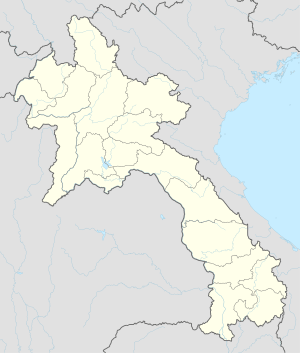 Luang Namtha Location in Laos | |
| Coordinates: 20°57′N 101°24′E | |
| Country | Laos |
| Admin. division | Luang Namtha Province |
| Population (2015) | |
| • Total | 28,551 |
| • Religions | Buddhism |
| Time zone | UTC+7 (ICT) |
Luang Namtha is a popular tourist destination, and a base for treks, biking to the surrounding hill tribe villages. The Luang Namtha Museum is in the town.
History
From January through May 1962, troops from the Royal Lao Army (RLA) fought the Pathet Lao and People's Army of Vietnam in the Battle of Luang Namtha. The battle ended with the RLA's headlong retreat southward 150 kilometers across the Mekong River.[1]
Transport
In the rainy season, Luang Namtha can be reached by boat from the Mekong River. It is connected by Highway 3 to both the Thai border at Houayxay-Chiang Khong (197 km (122 mi)) and the Chinese border at Boten-Mengla County (60 km (37 mi)). Luang Namtha is also served by Louang Namtha Airport, 6 km (3.7 mi) south of the city.
Gallery
 Day market
 Night market
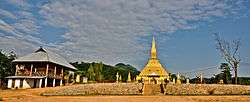
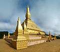 Luang Namtha stupa
 Harvesting rice
 Riverside guesthouse
References
- Conboy, Kenneth; Morrison, James (1995). Shadow War: The CIA's Secret War in Laos. Paladin Press. pp. 67–73. ISBN 0-87364-825-0. Retrieved 31 May 2020.
External links


- Biodiversity Profile for Luang Namtha Province, 2003(subscription required)
- Ethnic diversity in Luang Namtha - Laos
- Facebook photo gallery(subscription required)