Logan Township, Pike County, Indiana
Logan Township is one of nine townships in Pike County, Indiana, United States. As of the 2010 census, its population was 474 and it contained 175 housing units.[1]
Logan Township Pike County | |
|---|---|
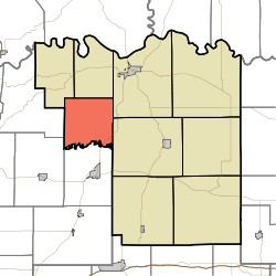 Location in Pike County | |
| Coordinates: 38°25′01″N 87°21′33″W | |
| Country | |
| State | |
| County | Pike |
| Government | |
| • Type | Indiana township |
| Area | |
| • Total | 24.31 sq mi (63.0 km2) |
| • Land | 23.94 sq mi (62.0 km2) |
| • Water | 0.37 sq mi (1.0 km2) 1.52% |
| Elevation | 446 ft (136 m) |
| Population (2010) | |
| • Total | 474 |
| • Density | 19.8/sq mi (7.6/km2) |
| ZIP codes | 47567, 47598 |
| GNIS feature ID | 453580 |
History
Logan Township was organized in 1846.[2]
Geography
According to the 2010 census, the township has a total area of 24.31 square miles (63.0 km2), of which 23.94 square miles (62.0 km2) (or 98.48%) is land and 0.37 square miles (0.96 km2) (or 1.52%) is water.[1] The Patoka River defines the township's southern border.
Unincorporated towns
- Chandler at 38.421437°N 87.352237°W
- Coats Spring at 38.437548°N 87.390572°W
- Oatsville at 38.4069919°N 87.4075169°W
- Rumble at 38.435882°N 87.342793°W
(This list is based on USGS data and may include former settlements.)
Cemeteries
The township contains these seven cemeteries: Barnes, Beck, DeJarnett, Loveless, McGillem, Willis and Wilson.
School districts
- Pike County School Corporation
Political districts
- State House District 64
- State Senate District 48
References
- "Logan Township, Pike County, Indiana". Geographic Names Information System. United States Geological Survey. Retrieved 2009-11-26.
- United States Census Bureau 2009 TIGER/Line Shapefiles
- IndianaMap
- "Population, Housing Units, Area, and Density: 2010 - County -- County Subdivision and Place -- 2010 Census Summary File 1". United States Census. Archived from the original on 2020-02-12. Retrieved 2013-05-10.
- History of Pike and Dubois Counties, Indiana. Goodspeed Brothers. p. 276. ISBN 978-5-87521-222-2.
External links
- Indiana Township Association
- United Township Association of Indiana
- City-Data.com page for Logan Township
Places adjacent to Logan Township, Pike County, Indiana | |
|---|---|
Municipalities and communities of Pike County, Indiana, United States | ||
|---|---|---|
| City | Map of Indiana highlighting Pike County | |
| Towns | ||
| Townships | ||
| CDP | ||
| Other unincorporated communities |
| |
| Footnotes | ‡This populated place also has portions in an adjacent county or counties | |
This article is issued from Wikipedia. The text is licensed under Creative Commons - Attribution - Sharealike. Additional terms may apply for the media files.