Logan Square branch
The Logan Square branch[1] was a rapid transit branch which is part of the Chicago 'L' system. It opened on May 6, 1895 and closed south of Damen station on February 25, 1951, when it was partially replaced by the Milwaukee-Dearborn Subway.[2] The remainder of the branch is currently a part of the O'Hare branch of the Blue Line.
| Logan Square branch | |||||||||||||||||||||||||||||||||||||||||||||||||||||||||||||||||||||||||||||||||||||||||||||||||||||||||||||||||||||||||||||||||||||||||||||||||||||||||||||||||||||||||
|---|---|---|---|---|---|---|---|---|---|---|---|---|---|---|---|---|---|---|---|---|---|---|---|---|---|---|---|---|---|---|---|---|---|---|---|---|---|---|---|---|---|---|---|---|---|---|---|---|---|---|---|---|---|---|---|---|---|---|---|---|---|---|---|---|---|---|---|---|---|---|---|---|---|---|---|---|---|---|---|---|---|---|---|---|---|---|---|---|---|---|---|---|---|---|---|---|---|---|---|---|---|---|---|---|---|---|---|---|---|---|---|---|---|---|---|---|---|---|---|---|---|---|---|---|---|---|---|---|---|---|---|---|---|---|---|---|---|---|---|---|---|---|---|---|---|---|---|---|---|---|---|---|---|---|---|---|---|---|---|---|---|---|---|---|---|---|---|---|---|
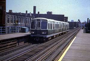 Damen Avenue, 1967 | |||||||||||||||||||||||||||||||||||||||||||||||||||||||||||||||||||||||||||||||||||||||||||||||||||||||||||||||||||||||||||||||||||||||||||||||||||||||||||||||||||||||||
| Overview | |||||||||||||||||||||||||||||||||||||||||||||||||||||||||||||||||||||||||||||||||||||||||||||||||||||||||||||||||||||||||||||||||||||||||||||||||||||||||||||||||||||||||
| Type | Rapid transit | ||||||||||||||||||||||||||||||||||||||||||||||||||||||||||||||||||||||||||||||||||||||||||||||||||||||||||||||||||||||||||||||||||||||||||||||||||||||||||||||||||||||||
| System | Chicago 'L' | ||||||||||||||||||||||||||||||||||||||||||||||||||||||||||||||||||||||||||||||||||||||||||||||||||||||||||||||||||||||||||||||||||||||||||||||||||||||||||||||||||||||||
| Status | Closed | ||||||||||||||||||||||||||||||||||||||||||||||||||||||||||||||||||||||||||||||||||||||||||||||||||||||||||||||||||||||||||||||||||||||||||||||||||||||||||||||||||||||||
| Locale | Chicago, Illinois, U.S. | ||||||||||||||||||||||||||||||||||||||||||||||||||||||||||||||||||||||||||||||||||||||||||||||||||||||||||||||||||||||||||||||||||||||||||||||||||||||||||||||||||||||||
| Stations | 6 | ||||||||||||||||||||||||||||||||||||||||||||||||||||||||||||||||||||||||||||||||||||||||||||||||||||||||||||||||||||||||||||||||||||||||||||||||||||||||||||||||||||||||
| Services | Blue Pink | ||||||||||||||||||||||||||||||||||||||||||||||||||||||||||||||||||||||||||||||||||||||||||||||||||||||||||||||||||||||||||||||||||||||||||||||||||||||||||||||||||||||||
| Operation | |||||||||||||||||||||||||||||||||||||||||||||||||||||||||||||||||||||||||||||||||||||||||||||||||||||||||||||||||||||||||||||||||||||||||||||||||||||||||||||||||||||||||
| Opened | May 6, 1895 | ||||||||||||||||||||||||||||||||||||||||||||||||||||||||||||||||||||||||||||||||||||||||||||||||||||||||||||||||||||||||||||||||||||||||||||||||||||||||||||||||||||||||
| Operator(s) | Chicago Transit Authority (1947-present) Chicago Rapid Transit Company (1924-1947) Metropolitan West Side Elevated Railroad (1895-1924) | ||||||||||||||||||||||||||||||||||||||||||||||||||||||||||||||||||||||||||||||||||||||||||||||||||||||||||||||||||||||||||||||||||||||||||||||||||||||||||||||||||||||||
| Character | Elevated | ||||||||||||||||||||||||||||||||||||||||||||||||||||||||||||||||||||||||||||||||||||||||||||||||||||||||||||||||||||||||||||||||||||||||||||||||||||||||||||||||||||||||
| Technical | |||||||||||||||||||||||||||||||||||||||||||||||||||||||||||||||||||||||||||||||||||||||||||||||||||||||||||||||||||||||||||||||||||||||||||||||||||||||||||||||||||||||||
| Track gauge | 4 ft 8 1⁄2 in (1,435 mm) | ||||||||||||||||||||||||||||||||||||||||||||||||||||||||||||||||||||||||||||||||||||||||||||||||||||||||||||||||||||||||||||||||||||||||||||||||||||||||||||||||||||||||
| Electrification | Third rail, 600 V DC | ||||||||||||||||||||||||||||||||||||||||||||||||||||||||||||||||||||||||||||||||||||||||||||||||||||||||||||||||||||||||||||||||||||||||||||||||||||||||||||||||||||||||
| |||||||||||||||||||||||||||||||||||||||||||||||||||||||||||||||||||||||||||||||||||||||||||||||||||||||||||||||||||||||||||||||||||||||||||||||||||||||||||||||||||||||||
Operations
The Logan Square branch separated from the Metropolitan Main Line at the Marshfield Junction, just west of the Marshfield station. The Humboldt Park branch split off just northwest of the Damen station (originally called Robey).[3]
History
Service began on the Northwest branch on May 6, 1895, with service as far as Robey Street (Damen Avenue),[2] and was extended to Logan Square on May 25, 1895.[4] On February 25, 1951, the Milwaukee-Dearborn subway began service, and service ended on the Logan Square branch south of the Damen Avenue station.
The portion between the subway portal the junction with the other Metropolitan West Side branches was retained as the Paulina Connector, a non-revenue connecting track, as the other Met branches were rerouted from the Loop into the south end of the Milwaukee–Dearborn subway, meaning there was no other connection to the rest of the "L" system. As part of the replacement of the Garfield Park branch with the Congress branch, a new junction between the Paulina Connector and the Lake Street branch was constructed, allowing trains from the Douglas branch to continue to reach the Loop while construction was ongoing. After construction was complete, Douglas branch trains resumed using the Milwaukee–Dearborn subway, and the connector was returned to non-revenue use only. The portion north of the Lake Street branch was demolished in 1964, as the junction with the Lake Street branch rendered it superfluous.
By 2003, the Paulina Connector was in need of renovation, as it remained the only connection between the Blue Line and the rest of the system. As part of a renovation of the Cermak (formerly Douglas) branch, the connector was rebuilt. Following the reconstruction, in 2006 the CTA introduced a new service pattern in which trains from the Cermak branch use the Paulina Connector to travel to the Loop via the junction with the Lake Street branch. This service is the current Pink Line.[5]
Besides the Paulina Connector and the section of the Blue Line between the subway and Logan Square, one other extant section remains at Paulina and Kinzie Streets, where the trestle over the Union Pacific (Former Milwaukee Road) Metra rail lines has been re-used as a signal bridge.
Stations
| Station | Location | Points of interest and notes |
|---|---|---|
| Logan Square | Kedzie Boulevard and Linden Place | Replaced by the Logan Square subway station |
| California | California Avenue and Lyndale Street | |
| Western | Western Avenue, Cortland Street and Milwaukee Avenue | |
| Damen | Damen Avenue, North Avenue and Milwaukee Avenue | Opened as "Robey" |
| Division | Division Street and Paulina Street | |
| Chicago | Chicago Avenue and Paulina Street | |
| Grand | Grand Avenue and Paulina Street | |
| Lake Street Transfer | Lake Street and Paulina Street | Opened as "Lake." Transfer to Lake Street. |
| Madison | 1720 W. Madison Street | Closed February 25, 1951 |
References
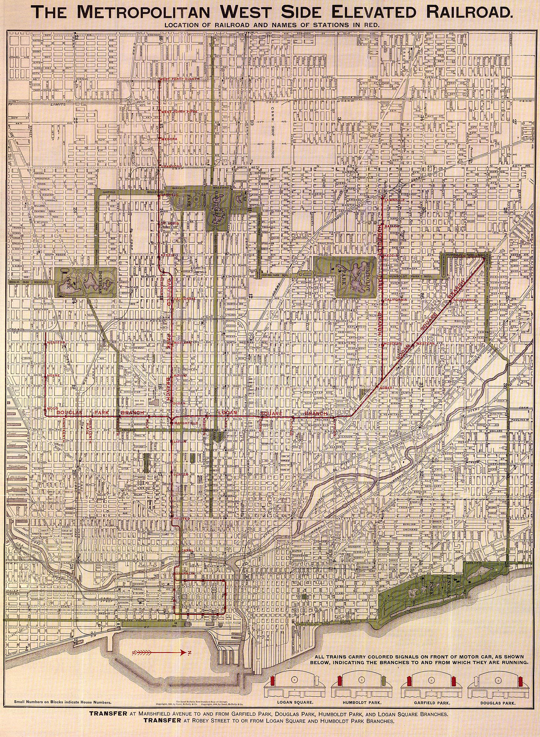
- The Metropolitan West Side Elevated Railroad (Map). Metropolitan West Side Elevated Railroad. 1898. Retrieved 2013-08-18.
- "Paulina Connector". Chicago "L".org. Retrieved August 18, 2013.
- 'L' Map of Chicago (Map). Chicago Rapid Transit Company. 1934. Retrieved 2013-08-18.
- "Logan Square". Chicago "L".org. Retrieved August 16, 2013.
- "Paulina Connector". chicago-l.org. Retrieved June 1, 2020.