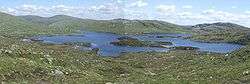
Loch Enoch
Loch Enoch is a multi-basin freshwater loch in Galloway, to the east of Merrick and south of Mullwharchar. The loch is situated in a granite basin and has several small islands and some beaches on its shore. The sharp granite sand of these beaches was collected and sold for sharpening knives and scythes.[2] The catchment area's vegetation is mainly Purple Moor Grass and Heather.[1]
| Loch Enoch | |
|---|---|
 | |
| Location | Galloway |
| Coordinates | 55°08′10″N 4°26′20″W |
| Type | Loch |
| Primary outflows | Eglin Lane |
| Catchment area | 186 ha (460 acres)[1] |
| Basin countries | Scotland |
| Surface area | 50 ha (120 acres)[1] |
| Max. depth | ~36 m (118 ft)[1] |
| Surface elevation | 493 m (1,617 ft)[1] |
| References | [1] |

The loch's outflow supplies Loch Doon and the River Doon, both in Ayrshire.
Acidification
By 1800 the water of Loch Enoch had already become acidic.[3] J. McBain in his 1929 book The Merrick and the Neighbouring Hills. Tramps by Hill, Stream and Loch describes a trout that 'bore the unmistakable marks of a Loch Enoch trout, i.e. it was minus the lower half of its tail and part of its ventral fins'.[4] McBain writes that the last recorded trout caught was in 1899. Since 1940 the loch became more acidic due to industrial emissions[3] and in the 1950s it completely lost its fish population.[5] In 1994 it was restocked with 3000 trout.[4] The loch has not become more acidic since the mid-1970s and has become slightly less acidic from the 1980s onwards,[1] with the pH increasing slowly from around 4.3 in 1978 to 4.9 in 2003.[6] Between 1983 and 2003 the loch's DOC levels increased.[7]
Water analysis
| Element | Concentration μg/l |
|---|---|
| CaCO3 | −500 |
| Li | 0.297 |
| Al | 83.9 |
| V | 0.263 |
| Cr | 0.147 |
| Fe | 49.3 |
| Fe DRC | 46.4 |
| Mn | 6.7 |
| Co | 0.064 |
| Ni | 0.348 |
| Cu | 0.247 |
| Zn | 3.14 |
| Se | 0.178 |
References
- Goudie, Andrew; Alexander, David (1997). Lake Acidification in Galloway. The Human Impact Reader: Readings and Case Studies. p. 201.
- Barratt, Edward. "'The Croft on the Flowe'". Climb Magazine. Archived from the original on 23 July 2008. Retrieved 24 June 2008.
- Dr John Kinross. "Freshwater Acidification and 'Acid Rain'". Lecture Notes for MSc Aquatic Ecosystems Management, Freshwater Ecosystems Module. Archived from the original on 4 March 2008. Retrieved 24 June 2008.
- "The Southern Uplands of Scotland". Scottish Mountain Photo Gallery. 5 June 2004. Archived from the original on 15 July 2004. Retrieved 24 June 2008.
- Richard W. Battarbee (1989). "The Acidification of Scottish Lochs". The Geographical Journal. 155: 353–360. doi:10.2307/635210. JSTOR 635210.
- "Recovery from Acid Rain Gives Hope to Scottish Upland Salmonid Populations" (PDF). Fisheries Research Services. 16 August 2004. Retrieved 25 June 2008.
- "Freshwater Environment Group" (PDF). Fisheries Research Services. Retrieved 28 June 2008.
- Robinson, Craig D.; Charles, Sylvie; Malcolm, Iain A.; Devalla, Sandhya (May 2007). "FRS METHOD FOR THE DETERMINATION OF TRACE METALS (INCLUDING RARE EARTH ELEMENTS) IN FRESHWATER SAMPLES BY INDUCTIVELY COUPLED PLASMA MASS SPECTROMETRY" (PDF). Fisheries Research Services. Retrieved 28 June 2008.