List of listed buildings in Kilmaronock, West Dunbartonshire
List
| Name | Location | Date Listed | Grid Ref. [note 1] | Geo-coordinates | Notes | LB Number [note 2] | Image |
|---|---|---|---|---|---|---|---|
| Auchenlarich With Stables And Gatepiers | 56°01′15″N 4°30′35″W | Category B | 43911 |  | |||
| Tullochan Farmhouse With Outbuildings | 56°02′24″N 4°32′39″W | Category B | 43924 | | |||
| Ross Priory, Lodge With Gatepiers | 56°03′01″N 4°32′09″W | Category B | 7626 | | |||
| Gartocharn, Chimes Cottage Including Ancillary Structures And Boundary Wall | 56°02′27″N 4°31′44″W | Category C(S) | 46543 | | |||
| Kilmaronock Parish Church With Graveyard, Boundary Wall And Gatepiers | 56°03′18″N 4°29′13″W | Category B | 7621 | | |||
| Ashfield House With Walled Gardens, Boundary Wall And Gatepiers | 56°01′22″N 4°33′35″W | Category B | 7631 | | |||
| Buchanan Estate, South Avenue, Gates, Gatepiers And Boundary Walls | 56°03′15″N 4°29′44″W | Category B | 43914 | | |||
| Caldarvan House | 56°01′51″N 4°30′59″W | Category C(S) | 43916 | | |||
| Kilmaronock House | 56°03′27″N 4°28′59″W | Category B | 43921 | | |||
| Ross Priory, Stables With Pigsty And Former Bothy | 56°03′23″N 4°32′45″W | Category C(S) | 13662 | | |||
| Kilmaronock Manse With Outbuildings | 56°03′19″N 4°29′16″W | Category C(S) | 7622 | | |||
| Boturich Castle With Quadrant Wall And Gatepiers | 56°01′36″N 4°35′20″W | Category B | 7627 | 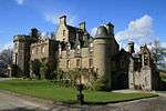 | |||
| Buchanan Estate, South Avenue Bridge | 56°03′50″N 4°29′39″W | Category B | 43912 | | |||
| Buchanan Estate, Woodend Lodge | 56°03′48″N 4°29′41″W | Category C(S) | 43915 | | |||
| Gartocharn Parish Church (Church Of Scotland) With Boundary Wall And Gatepiers | 56°02′39″N 4°31′29″W | Category B | 43920 | | |||
| Old Military Road, War Memorial With Boundary Wall | 56°02′55″N 4°30′42″W | Category C(S) | 43922 | | |||
| Kilmaronock Castle | 56°03′26″N 4°28′58″W | Category B | 7623 | | |||
| Ross Priory | 56°03′17″N 4°32′51″W | Category A | 7625 |  | |||
| Gartocharn, Former United Free Church Manse With Boundary Wall, Gatepiers And Gates | 56°02′31″N 4°31′40″W | Category C(S) | 43919 | | |||
| Buchanan Estate, South Avenue, Gargowan Lodge | 56°03′15″N 4°29′44″W | Category C(S) | 43913 | | |||
| Duncryne House | 56°02′20″N 4°31′05″W | Category C(S) | 43917 | | |||
| Ross Priory, Buchanan Burial Ground With Memorial And Gatepiers | 56°03′12″N 4°32′25″W | Category B | 43923 | | |||
| Inchmurrin, Lennox Castle | 56°02′31″N 4°36′48″W | Category B | 7624 | |
Key
The scheme for classifying buildings in Scotland is:
- Category A: "buildings of national or international importance, either architectural or historic; or fine, little-altered examples of some particular period, style or building type."[1]
- Category B: "buildings of regional or more than local importance; or major examples of some particular period, style or building type, which may have been altered."[1]
- Category C: "buildings of local importance; lesser examples of any period, style, or building type, as originally constructed or moderately altered; and simple traditional buildings which group well with other listed buildings."[1]
In March 2016 there were 47,288 listed buildings in Scotland. Of these, 8 per cent were Category A, and 50 per cent were Category B, with the rest listed at Category C.[2]
Notes
- Sometimes known as OSGB36, the grid reference (where provided) is based on the British national grid reference system used by the Ordnance Survey.
• "Guide to National Grid". Ordnance Survey. Retrieved 2007-12-12.
• "Get-a-map". Ordnance Survey. Retrieved 2007-12-17. - Historic Environment Scotland assign a unique alphanumeric identifier to each designated site in Scotland, for listed buildings this always begins with "LB", for example "LB12345".
References
- All entries, addresses and coordinates are based on data from Historic Scotland. This data falls under the Open Government Licence
- "What is Listing?". Historic Environment Scotland. Retrieved 29 May 2018.
- Scotland's Historic Environment Audit 2016 (PDF). Historic Environment Scotland and the Built Environment Forum Scotland. pp. 15–16. Retrieved 29 May 2018.
This article is issued from Wikipedia. The text is licensed under Creative Commons - Attribution - Sharealike. Additional terms may apply for the media files.