List of listed buildings in Cardross, West Dunbartonshire
List
| Name | Location | Date Listed | Grid Ref. [note 1] | Geo-coordinates | Notes | LB Number [note 2] | Image |
|---|---|---|---|---|---|---|---|
| Renton, Kipperoch Road, Kipproch House With Gates And Gatepiers | 55°57′44″N 4°36′17″W | Category C(S) | 42923 |  | |||
| Renton, Main Street, War Memorial | 55°58′10″N 4°35′03″W | Category B | 42927 | | |||
| Renton, Dalmoak House, Stable Courtyard And Walled Garden | 55°57′35″N 4°35′32″W | Category B | 1161 | | |||
| Renton, Main Street, Smollett Monument | 55°58′11″N 4°35′04″W | Category A | 1168 |  | |||
| Renton, Alexander Street, Trinity Parish Church, Church Of Scotland With Boundary Wall And Gatepiers | 55°58′04″N 4°34′55″W | Category B | 42920 | 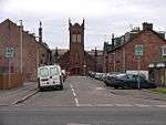 | |||
| Renton, Main Street, Public Library With Boundary Wall And Railings | 55°58′03″N 4°35′04″W | Category C(S) | 42925 | 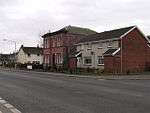 | |||
| Renton, Dalmoak House, North Gates And Gatepiers | 55°57′47″N 4°35′11″W | Category B | 42921 | | |||
| Renton, Kipperoch Road, Kipperoch Farmhouse And Steading | 55°57′44″N 4°36′26″W | Category B | 42922 | | |||
| Renton, Main Street, Argyle Cottage With Boundary Wall And Railings | 55°58′09″N 4°35′01″W | Category C(S) | 42924 | | |||
| Renton, Main Street, Sullivan's Bar | 55°58′19″N 4°35′04″W | Category C(S) | 42926 | | |||
| Renton, 123-127 Main Street, Central Bar | 55°58′16″N 4°35′04″W | Category B | 42928 | | |||
| Renton, 18 And 22 Main Street, With Boundary Wall And Railings | 55°58′06″N 4°35′01″W | Category C(S) | 42929 | | |||
| Renton, Dalmoak House | 55°57′34″N 4°35′27″W | Category A | 45600 | 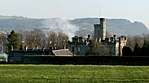 | |||
| Renton, Dalmoak House, Mains Lodge With Gates, Gatepiers And Boundary Wall | 55°57′27″N 4°35′19″W | Category B | 1163 | | |||
| Renton, Main Street, Millburn Church, Former Free Church With Boundary Wall, Gravestones, Railings And Gatepiers | 55°58′34″N 4°35′06″W | Category A | 1176 | |
Key
The scheme for classifying buildings in Scotland is:
- Category A: "buildings of national or international importance, either architectural or historic; or fine, little-altered examples of some particular period, style or building type."[1]
- Category B: "buildings of regional or more than local importance; or major examples of some particular period, style or building type, which may have been altered."[1]
- Category C: "buildings of local importance; lesser examples of any period, style, or building type, as originally constructed or moderately altered; and simple traditional buildings which group well with other listed buildings."[1]
In March 2016 there were 47,288 listed buildings in Scotland. Of these, 8 per cent were Category A, and 50 per cent were Category B, with the rest listed at Category C.[2]
Notes
- Sometimes known as OSGB36, the grid reference (where provided) is based on the British national grid reference system used by the Ordnance Survey.
• "Guide to National Grid". Ordnance Survey. Retrieved 2007-12-12.
• "Get-a-map". Ordnance Survey. Retrieved 2007-12-17. - Historic Environment Scotland assign a unique alphanumeric identifier to each designated site in Scotland, for listed buildings this always begins with "LB", for example "LB12345".
References
- All entries, addresses and coordinates are based on data from Historic Scotland. This data falls under the Open Government Licence
- "What is Listing?". Historic Environment Scotland. Retrieved 29 May 2018.
- Scotland's Historic Environment Audit 2016 (PDF). Historic Environment Scotland and the Built Environment Forum Scotland. pp. 15–16. Retrieved 29 May 2018.
This article is issued from Wikipedia. The text is licensed under Creative Commons - Attribution - Sharealike. Additional terms may apply for the media files.