List of lighthouses in Oregon
This is a list of current and former lighthouses in Oregon.
| Name | Image | Location | Coordinates | Year first lit | Automated | Year deactivated | Current Lens | Height |
|---|---|---|---|---|---|---|---|---|
| Cape Arago Light |  |
Coos Bay | 43.34123°N 124.37543°W | 1866 (First) 1934 (Current) |
1966 | 2006 (Now tribal land) |
None | 44 ft (13 m) |
| Cape Blanco Light |  |
Port Orford | 42.8365897°N 124.5633023°W | 1870 | 1980 | Active | Second-order Fresnel | 59 ft (18 m) |
| Cape Meares Light |  |
Oceanside (Cape Meares) |
45.486556°N 123.978389°W | 1890[1] | Never (Replaced in 1963) |
1963 (Replacement light deactivated in 2014.[2]) |
First-order Fresnel | 38 ft (12 m)[3] |
| Cleft of the Rock Light |  |
Yachats | 44.290479°N 124.110773°W | 1976[4] | Always | Active | Fourth-order Fresnel | 34 ft (10 m) |
| Coquille River Light | 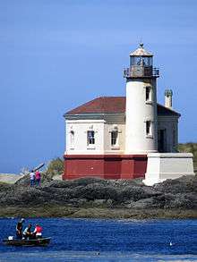 |
Bandon | 43.123911°N 124.424222°W | 1896 | Never (Relit in 1991) |
1939 | Decorative | 40 ft (12 m) |
| Desdemona Sands Light | Astoria | 46.22528°N 123.95361°W[5] | 1901 | 1934 | 1965 (Demolished) |
None | 48 ft (15 m) | |
| Heceta Head Light |  |
Florence | 44.13737°N 124.127835°W | 1894 | 1963 | Active | First-order Fresnel | 56 ft (17 m) |
| Pelican Bay Light (aka: Port of Brookings Light[6] |
Brookings | 42.04175°N 124.26279°W | 1997 (Private light) |
Always | Active | Unknown | 35 ft (11 m) | |
| Point Adams Light | Astoria | 46.188333°N 123.977778°W | 1875 | Always | 1899 (Demolished in 1912) |
None | 49 ft (15 m) | |
| Tillamook Rock Light |  |
Seaside (Tillamook Head) |
45.9375°N 124.019°W | 1881[7] | Never | 1957[8] | None | 62 ft (19 m) |
| Umpqua River Light |  |
Winchester Bay | 43.662291°N 124.198476°W | 1857 (First) 1894 (Current) |
1966 | Active | First-order Fresnel | 61 ft (19 m) |
| Warrior Rock Light | 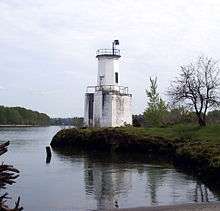 |
Sauvie Island | 45.84858°N 122.78835°W | 1877 (First) 1970s (Current) |
1930 | Active | Unknown | 25 ft (7.6 m) |
| Willamette River Light | Portland | 45.65301°N 122.76300°W | 1895 | 1935 | 1950s (Burned down) |
None | Unknown | |
| Yaquina Bay Light | 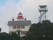 |
Newport | 44.62415°N 124.06290°W | 1871 | 1996 (Relit) |
Active (Inactive: 1874–1996) |
250mm | 51 ft (16 m) |
| Yaquina Head Light | 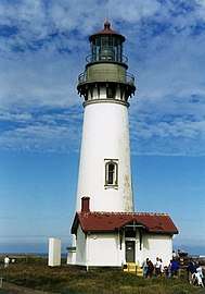 |
Newport | 44.676778°N 124.079417°W | 1873[9] | 1966[9] | Active | First-order Fresnel | 93 ft (28 m) |
See also
References
- "Historic Light Station Information & Photography: Oregon". U.S. Coast Guard. Retrieved November 20, 2014.
- "Weather or Not: Go Fly A Kite - www.newslincolncounty.com June 28, 2014".
- "Oregon Coast Lighthouses" (PDF). Oregon Parks and Recreation Department. p. 2. Archived from the original (PDF) on December 28, 2014. Retrieved January 2, 2015.
- Young, Don; Young, Marjorie (2009). Adventure Guide to the Pacific Northwest. Edison, New Jersey: Hunter Publishing. p. 107. ISBN 1-58843-131-2.
- "Desdemona Sands Light". Placenames.com. Archived from the original on 2012-02-15. Retrieved 2008-11-23.
- "Oregon Almanac: Hydropower Projects to State Motto". Oregon Blue Book. Oregon Secretary of State. Retrieved November 20, 2014.
- Cowan, Ron (April 30, 2005). "Loud past, quiet future". Statesman Journal. Salem, Oregon. Archived from the original on February 3, 2013. Retrieved November 11, 2014.
- Yardley, William (October 24, 2007). "Terrible Tillie, Where the Departed Rest Not Quite in Peace". The New York Times. Retrieved November 11, 2014.
- "Yaquina Head Lighthouse". Bureau of Land Management. Retrieved November 11, 2014.
External links
| Wikimedia Commons has media related to Lighthouses in Oregon. |
- Illustrated map showing location, range, photos, height, visiting hours, etc.
This article is issued from Wikipedia. The text is licensed under Creative Commons - Attribution - Sharealike. Additional terms may apply for the media files.