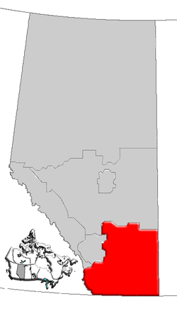
List of historic places in Southern Alberta
This article is a list of historic places in Southern Alberta entered on the Canadian Register of Historic Places, whether they are federal, provincial, or municipal.
List
| Name | Address | Coordinates | IDF | IDP | IDM | Image | |
|---|---|---|---|---|---|---|---|
| Blackfoot Crossing National Historic Site of Canada | Blackfoot Crossing, Siksika 146, AB | 50°48′15″N 112°54′23″W | 1165 | 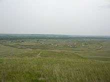 | |||
| Federal Building | 704 4 Ave S, Lethbridge, AB | 49°41′40″N 112°50′13″W | 3092 |  | |||
| Brooks Aqueduct | off the Trans-Canada Highway, southeast of Brooks, Newell County, AB | 50°31′54″N 111°50′17″W | 17702 | 2895 | 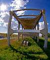 More images | ||
| Canadian Pacific Railway Station Building | Railway Ave. and Center St., Empress, AB | 50°57′33″N 110°00′29″W | 6703 | 3191 | | ||
| Canadian Pacific Railway Station | 402 North Railway St., Medicine Hat, AB | 50°02′23″N 110°40′18″W | 9321 | | |||
| Canadian Pacific Langevin Number 1 and 2 Gas Wells | , Cypress County, AB | 50°16′57″N 111°20′53″W | 5895 | | |||
| Hoodoos | Drumheller, Drumheller, AB | 51°22′51″N 112°32′02″W | 8813 | Q26381933 | 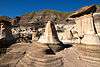 More images | ||
| United Grain Growers - Alberta Wheat Pool Grain Elevator Site Complex | near Rowley, Starland County, AB | 51°45′39″N 112°46′52″W | 8982 | | |||
| Searle Grain Company Grain Elevator Site Complex | near Rowley, Starland County, AB | 51°45′40″N 112°46′48″W | 8983 | | |||
| Gleichen Water Tower | Gleichen, Wheatland County, AB | 50°52′07″N 113°03′07″W | 9606 | 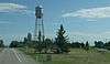 More images | |||
| St. Ambrose Anglican Church | 505 - 5 Street SE, Redcliff, AB | 50°04′23″N 110°46′55″W | 10482 |  | |||
| Alberta Wheat Pool Grain Elevator and Bow Slope Stockyard | EID Historic Park, Scandia, Newell County, AB | 50°16′44″N 112°02′56″W | 11471 | | |||
| Atlas No. 3 Coal Mine National Historic Site of Canada | near East Coulee, Drumheller, AB | 51°19′47″N 112°28′59″W | 11712 | 8998 | Q4816792 | .JPG) More images | |
| Alberta Provincial Police Building | Coleman, Crowsnest Pass, AB | 49°38′5.719″N 114°30′5.098″W | 2890 | Q33212176 |  More images | ||
| Blairmore Courthouse | Blairmore, Crowsnest Pass, AB | 49°36′26.521″N 114°25′53.245″W | 2891 | Q33212436 |  More images | ||
| Old Coleman High School | Coleman, Crowsnest Pass, AB | 49°38′5.3″N 114°30′10.8″W | 3007 | Q34204526 |  More images | ||
| Cardston Courthouse | 89 - 3 Avenue SW, Cardston, AB | 49°11′57″N 113°18′14″W | 3051 | | |||
| C.O. Card House | 337 Main Street, Cardston, AB | 49°11′54″N 113°18′07″W | 5743 | | |||
| Drewry House | near Cowley, Pincher Creek Municipal District No. 9, AB | 49°36′16″N 114°07′16″W | 5890 | | |||
| Stirling Agricultural Village National Historic Site of Canada | 4 Ave & 1 St, Stirling, AB | 49°30′00″N 112°31′01″W | 7773 |  More images | |||
| Hoyt Tipi Ring Site | west of Del Bonita, Cardston County, AB | 49°03′05″N 112°56′38″W | 8137 | | |||
| Noble Cultivators Retail Manufacturing Building | 914 Highway Avenue, Nobleford, AB | 8251 | | ||||
| Magrath Canal | , Magrath, AB | 49°24′14″N 112°52′12″W | 8355 | | |||
| Leitch (Passberg) Collieries | west of Burmis, Crowsnest Pass, AB | 49°33′32″N 114°19′19″W | 8746 | Q38528239 |  More images | ||
| Old Hillcrest Cemetery | , Crowsnest Pass, AB | 49°34′31.4″N 114°22′47.6″W | 8747 | Q34206129 | .jpg) More images | ||
| Latter Day Saints Park Avenue Chapel | 4 Park Avenue, Raymond, AB | 49°27′40″N 112°39′43″W | 8760 | | |||
| Raymond Buddhist Church | 35 Broadway Avenue, Raymond, AB | 49°27′38″N 112°39′43″W | 8773 | | |||
| Áísínai'pi National Historic Site of Canada | Writing-on-Stone Provincial Park, Warner County No. 5, AB | 49°04′54″N 111°37′01″W | 10424 |  More images | |||
| Isolation Hospital | 1920 - 7 Avenue South, Lethbridge, AB | 10480 | | ||||
| Cobblestone Manor | 173 - 7 Avenue West, Cardston, AB | 49°11′32″N 113°18′22″W | 10934 | | |||
| Frank Slide | Frank, Crowsnest Pass, AB | 49°35′28″N 114°23′42″W | 11500 | Q820306 | 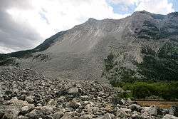 More images | ||
| Ross Archaeological Site | northeast of Coaldale, Lethbridge County, AB | 49°51′51″N 112°31′08″W | 11561 | | |||
| Coleman Union Hall / Hospital | Coleman, Crowsnest Pass, AB | 49°38′5.680″N 114°30′5.663″W | 11844 | Q37777637 | | ||
| Andreas Michelsen Farmstead | 533 - 2 Avenue, Stirling, AB | 49°30′23″N 112°31′55″W | 11903 |  More images | |||
| Coleman National Historic Site of Canada | , Crowsnest Pass, AB | 49°38′7″N 114°30′11″W | 11933 | Q5142969 |  More images | ||
| Temple of the Church of Jesus Christ of Latter Day Saints National Historic Site of Canada | 348 Third Street West, Cardston, AB | 49°11′53″N 113°18′40″W | 12645 |  More images | |||
| Fort Macleod National Historic Site of Canada | , Fort MacLeod, AB | 49°43′27″N 113°24′29″W | 1140 |  More images | |||
| Grier Block | 2305/2311 - 2 Avenue, Fort MacLeod, AB | 49°43′30″N 113°24′32″W | 4944 | | |||
| Empress Theatre | 235 - 24 Street, Fort MacLeod, AB | 49°43′32″N 113°24′29″W | 5891 | | |||
| Union Bank Building | 163 - 23rd Street, Fort MacLeod, AB | 49°43′29″N 113°24′22″W | 18049 | | |||
| A.Y. Young Drug Store | 210 - 24 Street, Fort MacLeod, AB | 49°43′31″N 113°24′29″W | 8789 | | |||
| Milnes Block | 105, 107, 109 - 50 Avenue West, and 4925 / 4927 - 1 Street, Claresholm, AB | 50°01′34″N 113°34′55″W | 8805 | | |||
| Village of Lille | north of Blairmore, Ranchland Municipal District No. 66, AB | 49°39′08″N 114°23′49″W | 11391 | | |||
| Hetherington Erratics Field | south of Fort MacLeod, Willow Creek Municipal District No. 26, AB | 49°33′54″N 113°26′20″W | 11476 | | |||
| Circle L Ranch | west of Claresholm, Willow Creek Municipal District No. 26, AB | 50°02′01″N 113°52′37″W | 11615 | | |||
| The Leavings at Willow Creek | north of Claresholm, Willow Creek Municipal District No. 26, AB | 50°05′24″N 113°34′55″W | 11967 | | |||
| Canadian Pacific Railway Station | 5126 1st Street W, Claresholm, AB | 50°01′40″N 113°34′57″W | 5742 | | |||
| Former Canadian Northern Railway Station | Railway Avenue (between Centre St. and 1 St. W), Hanna, AB | 51°38′30″N 111°55′30″W | 6708 | | |||
| Territorial Court House National Historic Site of Canada | 236 23rd Street, Fort MacLeod, AB | 49°43′28″N 113°24′25″W | 12566 | 5917 |  More images | ||
| Renwick Building | 223 - 24 Street, Fort MacLeod, AB | 49°43′33″N 113°24′29″W | 13348 | | |||
| A.G.T. Building | 232 - Centre Street, Vulcan, AB | 50°24′12″N 113°15′50″W | 13372 | | |||
| St. Anne Ranch | south of Trochu, Kneehill County, AB | 51°48′37″N 113°13′26″W | 9204 | | |||
| Cousins Residence | 271 - 1 Street SE, Medicine Hat, AB | 50°02′21″N 110°41′02″W | 5916 |  More images | |||
| Medicine Hat Courthouse | 460 - 1 Street SE, Medicine Hat, AB | 50°02′27″N 110°40′48″W | 5918 | 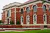 More images | |||
| Ewart-Duggan Residence | 443 - 1 Street SE, Medicine Hat, AB | 50°02′24″N 110°40′48″W | 7515 | More images | |||
| Cypress Club | 218 - 6 Avenue SE, Medicine Hat, AB | 50°02′24″N 110°40′34″W | 8486 | 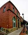 More images | |||
| Hycroft China Ltd. Factory | 701 - 703 Wood Street, Medicine Hat, AB | 50°01′51″N 110°39′25″W | 11505 | 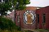 More images | |||
| Medalta Potteries | 713 Medalta Avenue, Medicine Hat, AB | 50°1′55.164″N 110°38′58.474″W | 12132 | 3444 | Q23706050 | 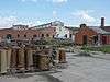 More images | |
| St. Patrick's Roman Catholic Church National Historic Site of Canada | 238 2nd Avenue, Medicine Hat, AB | 50°02′43″N 110°40′52″W | 12913 |  More images | |||
| Saamis Site | , Medicine Hat, AB | 50°01′01″N 110°41′46″W | 11513 | | |||
| Canadian Imperial Bank of Commerce | 577 2nd Street E, Medicine Hat, AB | 50°02′26″N 110°40′36″W | 8761 | | |||
| Canadian Imperial Bank of Commerce | 5227 48th Street W, Taber, AB | 49°47′05″N 112°08′42″W | 8253 | | |||
| Conybeare Residence | 422 - 6 Avenue South, Lethbridge, AB | 49°41′27″N 112°50′24″W | 2120 | | |||
| Bowman Arts Centre | 811 - 5 Avenue South, Lethbridge, AB | 49°41′36″N 112°50′04″W | 2892 | | |||
| Chinese Free Masons Building | 310 - 2 Avenue South, Lethbridge, AB | 49°41′47″N 112°50′35″W | 2893 | | |||
| Riverview C.A. Magrath House | 109 - 7 Avenue South, Lethbridge, AB | 49°41′19″N 112°50′46″W | 5893 | 11074 | | ||
| Lethbridge Fire Hall No. 1 | 402 - 2 Avenue South, Lethbridge, AB | 49°41′47″N 112°50′31″W | 8083 | | |||
| Kuo Min Tang (Chinese National League) Building | 309 - 2 Avenue South, Lethbridge, AB | 49°41′48″N 112°50′35″W | 8729 | | |||
| Dr. Arthur Haig Residence | 1115 - 8 Avenue South, Lethbridge, AB | 49°41′18″N 112°49′44″W | 8785 | | |||
| W.D.L. Hardie Residence | 1242 - 5 Avenue South, Lethbridge, AB | 49°41′35″N 112°49′34″W | 8786 | | |||
| Lethbridge Canadian Pacific Railway Station | 801 - 1 Avenue South, Lethbridge, AB | 49°41′54″N 112°50′10″W | 11966 | | |||
| Duke of Sutherland Site Complex | east of Brooks, Newell County, AB | 50°34′21″N 111°50′17″W | 5138 | | |||
| Former Engineer's House | 50 and 54 Evergreen Park Close, Brooks, AB | 50°33′56″N 111°54′14″W | 11929 | | |||
| Registration Building | Waterton Lakes National Park, Waterton Improvement District No. 04, AB | 49°05′00″N 113°52′01″W | 3423 | 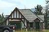 More images | |||
| RCMP Detachment Building | 202 Waterton Avenue, Waterton, Waterton Improvement District No. 04, AB | 49°06′01″N 113°54′32″W | 3601 | | |||
| RCMP Detachment Garage | , Waterton Improvement District No. 04, AB | 49°06′01″N 113°54′32″W | 3602 | | |||
| First Oil Well in Western Canada National Historic Site | Akamina Parkway, Waterton Lakes National Park of Canada, Waterton Improvement District No. 04, AB | 49°04′16″N 113°59′13″W | 4210 | 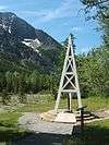 More images | |||
| Prince of Wales Hotel National Historic Site of Canada | Waterton Lakes National Park, Waterton Improvement District No. 04, AB | 49°03′22″N 113°54′43″W | 4307 | 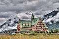 More images | |||
| Central Laboratory (B-1) | Canadian Forces Base Suffield / Base des Forces canadiennes de Suffield, Cypress County, AB | 50°27′40″N 110°44′35″W | 9587 | | |||
| Ralston School (R2) | Ralston, Cypress County, AB | 50°14′45.960″N 111°9′54.000″W | 9626 | Q41282364 |  More images | ||
| Blood Indian Hospital | 95 - 1 Avenue North, Cardston, AB | 49°12′00″N 113°18′00″W | 9737 | | |||
| Comfort Station 1 | Waterton, Waterton Improvement District No. 04, AB | 49°03′03″N 113°54′32″W | 10137 | | |||
| Comfort Station 2 | Waterton, Waterton Improvement District No. 04, AB | 49°02′53″N 113°54′32″W | 10138 | | |||
| Comfort Station 6 | Waterton, Waterton Improvement District No. 04, AB | 49°02′52″N 113°54′43″W | 10139 | | |||
| Comfort Station 8 | Waterton, Waterton Improvement District No. 04, AB | 49°02′49″N 113°54′43″W | 10140 | | |||
| Comfort Station 9 | Waterton, Waterton Improvement District No. 04, AB | 49°02′39″N 113°54′54″W | 10141 | | |||
| Interpretive Building | Waterton, Waterton Improvement District No. 04, AB | 49°02′55″N 113°54′29″W | 10146 | | |||
| Kitchen Shelter 7 | Waterton, Waterton Improvement District No. 04, AB | 49°02′42″N 113°54′54″W | 10203 | | |||
| Kitchen Shelter 13 | Waterton, Waterton Improvement District No. 04, AB | 49°02′56″N 113°54′36″W | 10204 | | |||
| Kitchen Shelter 1 | Waterton, Waterton Improvement District No. 04, AB | 49°02′51″N 113°54′32″W | 10205 | | |||
| Kitchen Shelter 2 | Waterton, Waterton Improvement District No. 04, AB | 49°02′51″N 113°54′32″W | 10206 | | |||
| Kitchen Shelter 6 | Waterton, Waterton Improvement District No. 04, AB | 49°02′42″N 113°54′50″W | 10207 | | |||
| Kitchen Shelter 8 | Waterton, Waterton Improvement District No. 04, AB | 49°02′47″N 113°54′50″W | 10208 | | |||
| Kitchen Shelter 9 | Waterton, Waterton Improvement District No. 04, AB | 49°02′48″N 113°54′50″W | 10209 | | |||
| Kitchen Shelter 11 | Waterton, Waterton Improvement District No. 04, AB | 49°02′56″N 113°54′40″W | 10210 | | |||
| Kitchen Shelter 14 | Waterton, Waterton Improvement District No. 04, AB | 49°02′55″N 113°54′32″W | 10211 | | |||
| Laidlaw Antelope Trap | near Bow Island, Forty Mile County No. 8, AB | 10861 | | ||||
| Fort Whoop-Up Archaeological Site | Junction of the St. Mary and Oldman Rivers, Lethbridge, AB | 49°37′34″N 112°53′17″W | 18984 | 10972 | | ||
| Ward Effigy Archaeological Site | northeast of Cluny, Wheatland County, AB | 11403 | | ||||
| Dinosaur Egg Site | west of Warner, Warner County No. 5, AB | 11518 | | ||||
| Sir Alexander Galt Hospital | 502 - 1 Street South, Lethbridge, AB | 49°41′32″N 112°50′49″W | 11623 | | |||
| Medicine Hat Clay Industries National Historic Site of Canada | 703 Wood Street SE, Medicine Hat, AB | 50°01′53″N 110°38′53″W | 12133 | | |||
| British Block Cairn National Historic Site of Canada | , Cypress County, AB | 50°36′30″N 110°35′32″W | 14944 | 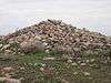 More images | |||
| Crowsnest Pass Polish Hall | Coleman, Crowsnest Pass, AB | 49°37′54.314″N 114°29′49.484″W | 15493 | Q37777699 | .jpg) More images | ||
| Majorville Cairn and Medicine Wheel site | near Bassano, Vulcan County, AB | 15835 | | ||||
| Treaty Nº 7 Signing Site National Historic Site of Canada | , Siksika Indian Reserve #146, AB | 50°47′12″N 112°53′42″W | 15908 |  More images | |||
| Suffield Tipi Rings National Historic Site of Canada | Cypress County, Cypress County, AB | 50°12′00″N 111°10′01″W | 16001 | | |||
| Doukhobor Prayer Home | 753 Kettles Street, Lundbreck, Pincher Creek Municipal District No. 9, AB | 49°35′03″N 114°09′43″W | 16362 | | |||
| Acadia Block | 614 (616) 3 Avenue South, Lethbridge, AB | 49°41′44″N 112°50′17″W | 17904 | | |||
| R.T. Barker Building | 232 - 24 Street, Fort MacLeod, AB | 49°43′31″N 113°24′29″W | 18050 | | |||
| Sunnyslope Sandstone Shelter | near Didsbury, Kneehill County, AB | 51°40′18″N 113°36′54″W | 18051 |  More images | |||
| West Canadian Collieries Mine | Bellevue, Crowsnest Pass, AB | 49°34′37.873″N 114°21′53.939″W | 18807 | Q38530898 | .jpg) More images | ||
| Lethbridge Manual Training School | 811 - 5 Avenue South, Lethbridge, AB | 49°41′36″N 112°50′10″W | 18864 | | |||
| Earthlodge Village National Historic Site of Canada | , Siksika Indian Reserve #146, AB | 19552 | More images |
See also
This article is issued from Wikipedia. The text is licensed under Creative Commons - Attribution - Sharealike. Additional terms may apply for the media files.