List of heritage sites in Eastern Cape
This is a list of the heritage sites in Eastern Cape as recognized by the South African Heritage Resource Agency. For performance reasons some districts have been split off from this list:
- List of heritage sites in Albany
- List of heritage sites in Graaff-Reinet
- List of heritage sites in Port Elizabeth
| SAHRA identifier | Site name | Description | Town | District | NHRA status | Coordinates | Image |
|---|---|---|---|---|---|---|---|
| Fort Murray, Zwelitsha District | After the Sixth Xhosa War (1834—1835) Sir Benjamin D'Urban annexed all the land between the Keiskamma and the Kei Rivers as part of the Cape Colony and called it the Province of Queen Adelaide. To protect this territory he started to build a network of forts.
Type of site: Fort. |
Zwelitsha | Zwelitsha | Provincial Heritage Site | 32°57′00″S 27°28′00″E |  | |
| 4/K/Ped/2 | Cavalry Barracks and Stables, Peddie | This military building complex was erected in about 1840 and until 1862 served as an important centre of among others, the Cape Mounted Riflemen. Hereafter some of the military buildings were used for many years as the Residency and postmaster's dwelling.
Type of site: Stables, Barracks. |
Peddie | Peddie | Provincial Heritage Site | 33°11′00″S 27°15′24″E | |
| 9/2/001/0003 | Post Office and Magistrate's Court, Grey Street, Aberdeen | Type of site: Courthouse and Post Office
Current use: Magistrate's Court and Post Office. Naude's nek is the highest mountain pass in the country and possibly the continent, that is negotiable by ordinary vehicles. Sani Pass, whose highest point is in Lesotho, is negotiable only by specialise off road vehicles. |
Aberdeen | Aberdeen | Provincial Heritage Site | 32°28′26″S 24°04′02″E | 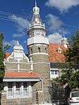 Type of site: Courthouse and Post Office
Current use: Magistrate's Court and Post Office.
Naude's nek is the highest mountain pass in the country and possibly the continent, that is negotiable by ordinary vehicles. Sani Pass, whose highest point is in Lesotho, is negotiable only by specialise off road vehicles. |
| 9/2/002/0004 | Our Heritage Museum, Queen Street, Adelaide | This parsonage was erected in about 1860 for the Rev. G. W. Stegman. The double-storeyed building is predominantly in the Georgian style and has large adjacent outbuildings dating from the same period. Architectural style: Georgian.
Type of site: House Previous use: Residential. Current use: Museum. |
Adelaide | Adelaide | Provincial Heritage Site | 32°42′36″S 26°17′50″E | 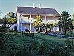 This parsonage was erected in about 1860 for the Rev. G. W. Stegman. The double-storeyed building is predominantly in the Georgian style and has large adjacent outbuildings dating from the same period. Architectural style: Georgian.
Type of site: House Previous use: Residential.
Current use: Museum. |
| 9/2/002/0005 | Glen Thorn Presbyterian Church, Glen Thorn, Adelaide District | The farm Glen Thorn lies about 26 kilometres north of Adelaide, on the left side of the road to Tarkastad. On this farm, in the Macazana Valley, there is a small church of great historical importance. Build of sandstone, plastered for protection 20 years Glen Thorn was granted in 1824 to John Pringle, a brother of Thomas Pringle the author and leader of the Scottish Party. It was John Pringle who built this stone church in 1840. The first minister was the Rev. John Forbes Cumming.
Type of site: Church Current use: Church. 14 km from Bedford turn left to the R344. Travel for 6,3km to T-junction. Turn left. Travel for 21,4km. Take turn-off to left (Glen Thorn). Church is 5,5km from turn-off. 5,1km from T-Junction to Adelaide. R344 is 7.3 km from Adelaide bridge. Oldest Presbyterian Church building used continuously for worship in the Eastern Cape. Built 1840. |
Adelaide | Provincial Heritage Site | 32°28′30″S 26°14′02″E | | |
| 9/2/004/0003 | Christ Church, Church Street, Burgersdorp | Architecturally, it is a high-roofed late-Victorian church building with neo—Gothic features. The east end has a facade broken by three lancet windows heavily rusticated and underlined by a plaster pediment. The side facades have three round-head casements. Towards 1844 about 300 families living between the Stormsbergspruit and the Kraai River were granted permission by the Dutch Reformed presbytery of Graaff-Reinet to establish a parish of their own. 27 December 1847 they purchased the farm Klipfontein.
Type of site: Church Current use: Church : Anglican. This church with its neo-Gothic features dates from the 1860s. The chancel was erected in 1902. |
Burgersdorp | Albert | Provincial Heritage Site | 30°59′39″S 26°19′47″E | |
| 9/2/004/0004 | De Bruin House, 66 Van der Walt Street, Burgersdorp | This cottage in the typical Karoo style was erected shortly after the founding of Burgersdorp in 1847. It was originally the town house of the De Bruins of Witkop.
Type of site: House Current use: Museum. |
Burgersdorp | Albert | Provincial Heritage Site | 30°59′34″S 26°19′51″E | |
| 9/2/004/0005 | Old Gaol, Van der Walt Street, Burgersdorp | This gaol was completed in 1861 and played an important role during the Anglo-Boer War and the Rebellion of 1914.
Type of site: Gaol Current use: Military Headquarters. |
Burgersdorp | Albert | Provincial Heritage Site | 30°59′36″S 26°19′50″E | |
| 9/2/004/0006 | Old Reformed Church Parsonage, Piet Retief Street, Burgersdorp | This Victorian house dates from the middle of the nineteenth century. From 1868 it served as parsonage for Prof. Dirk Postma, founder of the Reformed Church in South Africa. Prof. Jan Lion-Cachet also lived here from 1895.
Type of site: Parsonage Current use: Museum. |
Burgersdorp | Albert | Provincial Heritage Site | 30°59′44″S 26°19′50″E | |
| 9/2/004/0007 | Coetzee House, 51 Piet Retief Street, Burgersdorp | This cottage in the typical Karoo style was erected shortly after the founding of Burgersdorp in 1847. It was originally the town house of the Coetzees of the farm Swartfontein.
Type of site: House Current use: Museum. |
Burgersdorp | Albert | Provincial Heritage Site | 30°59′42″S 26°19′49″E | |
| 9/2/004/0008 | Taal Monument, Burger Square, Burgersdorp | The monument consists of a figure of a woman pointing with a finger at a tablet held in her left arm. On the tablet are the words ‘De overwinning der Hollandse Taal’. The figure stands on a massive granite base with suitable inscriptions. The monument ori The Theological Seminary, now in Potchefstroom, started in Burghersdorp and it was the centre of a strong movement for the recognition of Dutch as an official language. This is commemorated by the ‘Taalmonument’ which stands on Burger Square.
Type of site: Memorial. Current use: Memorial. |
Burgersdorp | Albert | Provincial Heritage Site | 30°59′38″S 26°19′53″E |  The monument consists of a figure of a woman pointing with a finger at a tablet held in her left arm. On the tablet are the words ‘De overwinning der Hollandse Taal’. The figure stands on a massive granite base with suitable inscriptions. The monument ori The Theological Seminary, now in Potchefstroom, started in Burghersdorp and it was the centre of a strong movement for the recognition of Dutch as an official language. This is commemorated by the ‘Taalmonument’ which stands on Burger Square.
Type of site: Memorial.
Current use: Memorial. |
| 9/2/004/0009 | Jubilee Fountain, Burger Square, Burgersdorp | Type of site: Memorial.
Current use: Memorial. |
Burgersdorp | Albert | Provincial Heritage Site | 30°59′36″S 26°19′54″E | 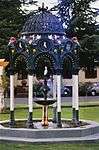 Type of site: Memorial.
Current use: Memorial. |
| 9/2/004/0010 | Anglo-Boer War Blockhouse #1, Burgersdorp | In Burgersdorp there is not only a monument to commemorate the struggle for the recognition of Dutch, but also another brings to mind the three-year-long Anglo Boer War. By this we do not refer to the Burger Monument, but to a blockhouse.
Type of site: Blockhouse |
Burgersdorp | Albert | Provincial Heritage Site | 30°59′37″S 26°19′31″E | 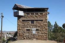 In Burgersdorp there is not only a monument to commemorate the struggle for the recognition of Dutch, but also another brings to mind the three-year-long Anglo Boer War. By this we do not refer to the Burger Monument, but to a blockhouse.
Type of site: Blockhouse |
| 9/2/004/0011 | Old Reformed Church Theological Seminary, Burgersdorp | In Piet Retief Street, between President Swart Road and Chase Street, the old parsonage of the Reformed congregation of Burgersdorp is situated. Behind it stands a modest outbuilding. In this outbuilding the Theological Seminary of the Reformed Church in In this building the Theological Seminary of the Gereformeerde Kerk in Suid-Afrika was established in 1869. In 1905 this institution was moved to Potchefstroom where it eventually gave rise to the Potchefstroom University for Christian Higher Education.
Type of site: Theological seminary. Current use: Museum. |
Burgersdorp | Albert | Provincial Heritage Site | 30°59′32″S 26°19′54″E | |
| 9/2/004/0014 | Dutch Reformed Church, Coetzee Street, Burgersdorp | Type of site: Church.
Current use: Church : Dutch Reformed. |
Burgersdorp | Albert | Provincial Heritage Site | 30°59′44″S 26°19′50″E |  Type of site: Church.
Current use: Church : Dutch Reformed. |
| 9/2/005/0003 | Dias Cross Memorial, Kwaaihoek, Alexandria District | A minor road turns sharply off to the right from the main road that leads from Alexandria to Bushman’s River Mouth; it passes Boknes and comes to an end near the coast. About a kilometre further east from the end of the road, beyond the sand dunes, lies K Bartholomew Diaz, the famous Portuguese navigator and discoverer of the Cape, erected a cross or padrao on 12 March 1488 at Kwaaihoek. A replica of the cross has been erected on the same bleak, exposed spot, high above the waves.
Type of site: Memorial. |
Alexandria | Alexandria | Provincial Heritage Site | 33°39′13″S 26°24′30″E | |
| 9/2/005/0004 | Dutch Reformed Church, Voortrekker Street, Alexandria | Type of site: Church.
Current use: Church. |
Alexandria | Alexandria | Provincial Heritage Site | 33°39′13″S 26°24′35″E |  Type of site: Church.
Current use: Church. |
| 9/2/006/0005 | Concentration Camp Garden of Remembrance, Aliwal North | Current use: Garden. The property is located 488 km from Port Elizabeth and located on the fringe of the CBD of Aliwal North, abutting the main road en route to Jameston-Queenstown, East London. The property is over the road from the Aliwal High School. | Aliwal North | Aliwal North | 30°42′17″S 26°42′30″E | | |
| 9/2/006/0010 | J W Sauer Bridge, Kraai River, Aliwal North District | This sandstone bridge with its four graceful arches was opened on 23 September 1881 by the then Minister of Railways and Harbours, Mr J. W. Sauer.
Type of site: Bridge Current use: Bridge. |
Aliwal North | Aliwal North | Provincial Heritage Site | 30°44′14″S 26°47′03″E | |
| 9/2/006/0011 | Anglo-Boer War Blockhouse #2, off Barkly Street, Aliwal North | This blockhouse, together with the second blockhouse on the southern side of Aliwal North, played an important strategic part during the Anglo-Boer War against the invading Republican commandos.
Type of site: Blockhouse. Current use: Blockhouse : Anglo-Boer War. |
Aliwal North | Aliwal North | Provincial Heritage Site | 30°41′15″S 26°43′10″E | 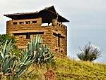 This blockhouse, together with the second blockhouse on the southern side of Aliwal North, played an important strategic part during the Anglo-Boer War against the invading Republican commandos.
Type of site: Blockhouse.
Current use: Blockhouse : Anglo-Boer War. |
| 9/2/006/0012 | Anglo-Boer War Blockhouse #1, Valk Street, Aliwal North | The town of Aliwal North owes its existence mainly to two of the oldest and most convenient drifts through the Orange River that formerly provided access between the Cape Colony and the Transgariep. Consequently it was of special strategic importance.
Type of site: Blockhouse. Current use: Blockhouse : Anglo-Boer War. |
Aliwal North | Aliwal North | Provincial Heritage Site | 30°42′15″S 26°42′55″E | |
| 9/2/007/0004 | Loch Bridge, Kraai River, Barkly East District | Type of site: Bridge.
Current use: Bridge. Take Divisional Road 3214 from Barkly East towards Lady Grey. Take New England turn-off. The Loch Bridge is crossed at 6,5km. |
Barkly East | Barkly East | Provincial Heritage Site | 30°54′23″S 27°34′20″E | 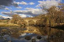 Type of site: Bridge.
Current use: Bridge. Take Divisional Road 3214 from Barkly East towards Lady Grey. Take New England turn-off. The Loch Bridge is crossed at 6,5km. |
| 9/2/007/0006 | Dutch Reformed Church, 125 Molteno Street, Barkly East | Type of site: Church.
Current use: Church : Dutch Reformed. The Barkly East Dutch Reformed Church is a very fine example of a religious building executed in sandstone. Besides the fine detailing of the exterior, this church, completed in 1907, has an interior which is still an accurate example of its period. |
Barkly East | Barkly East | Provincial Heritage Site | 30°58′02″S 27°35′35″E |  Type of site: Church.
Current use: Church : Dutch Reformed.
The Barkly East Dutch Reformed Church is a very fine example of a religious building executed in sandstone. Besides the fine detailing of the exterior, this church, completed in 1907, has an interior which is still an accurate example of its period. |
| 9/2/007/0007 | Old Primary School building, Visser Street, Rhodes | The facade is flanked by two gables at either end. Built in a U shape, the school has a roof of corrugated iron which extends over the building at the rear elevation to form a veranda which is supported by seven square stone pillars. Believed to have been designed by Sir Herbert Baker this sandstone building was erected during the last decade of the 19th century. As a result of the depopulation of Rhodes the school fell into disuse.
Type of site: School. Current use: Residential. |
Rhodes | Barkly East | Provincial Heritage Site | 30°58′11″S 28°15′50″E | |
| 9/2/007/0012 | Naudes Nek Pass, Barkly East District | Type of site: Pass.
Current use: Mountain Pass. |
Barkly East | Barkly East | Provincial Heritage Site | 30°43′57″S 28°08′13″E | |
| 9/2/009/0010 | Pig and Whistle Hotel, Kowie Road, Bathurst | Type of site: Hotel. | Bathurst | Bathurst | Provincial Heritage Site | 33°30′13″S 26°49′27″E |  Type of site: Hotel. |
| 9/2/009/0011 | White Gables, 15 Park Road, Port Alfred | This early Victorian dwelling-house with its two impressive triangular front gables dates from the 1830s and was erected by Captain Thomas Cowedroy. The two murals in the billiard room are also noteworthy. | Port Alfred | Bathurst | Provincial Heritage Site | 33°35′26″S 26°53′43″E | |
| 9/2/009/0012 | Old Powder Magazine, Bathurst | The historic powder magazine at Bathurst was erected in 1821 and carried, as regular stock, approximately 273 kilograms of gunpowder, 7000 ball cartridges and 60 rifles. It is an excellent example of British military architecture of the early nineteenth century.
Type of site: Powder Magazine. |
Bathurst | Bathurst | Provincial Heritage Site | 33°29′00″S 26°50′00″E |  The historic powder magazine at Bathurst was erected in 1821 and carried, as regular stock, approximately 273 kilograms of gunpowder, 7000 ball cartridges and 60 rifles. It is an excellent example of British military architecture of the early nineteenth century.
Type of site: Powder Magazine. |
| 9/2/009/0013 | Bradshaw's Mill, Bathurst | The structure originally consisted of two storeys measuring 5 m by 4 m internally. A third storey of brick was somewhat smaller and was probably added later. The roof was of slate from North Wales, brought out to Port Elizabeth as ships’ ballast. This wool mill was built in 1821 by Samuel Bradshaw, an 1820 Settler. It played an important role in the history of the wool industry in South Africa. The remains of the first wool mill to be built in the Eastern Province and probably the first in South Africa.
Type of site: Mill. |
Bathurst | Bathurst | Provincial Heritage Site | 33°30′35″S 26°48′54″E | 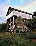 The structure originally consisted of two storeys measuring 5 m by 4 m internally. A third storey of brick was somewhat smaller and was probably added later. The roof was of slate from North Wales, brought out to Port Elizabeth as ships’ ballast. This wool mill was built in 1821 by Samuel Bradshaw, an 1820 Settler. It played an important role in the history of the wool industry in South Africa. The remains of the first wool mill to be built in the Eastern Province and probably the first in South Africa.
Type of site: Mill. |
| 9/2/009/0014 | Methodist Church complex, Clumber, Bathurst District | On this site the Nottingham party of British Settlers held a service of thanksgiving on their arrival in 1820 and built the first church in 1825. The second church, which replaced it in 1837, served as a defence station in 1846 during the hostilities.
Type of site: Church Complex. On |
Bathurst | Bathurst | Provincial Heritage Site | 33°29′00″S 26°50′00″E | .JPG) On this site the Nottingham party of British Settlers held a service of thanksgiving on their arrival in 1820 and built the first church in 1825. The second church, which replaced it in 1837, served as a defence station in 1846 during the hostilities.
Type of site: Church Complex. On |
| 9/2/009/0016 | Methodist Church, York Road, Bathurst | Besides St. John’s Church there is a second church with important historical associations in Bathurst. This one, too, has strong links with the history of the 1820 Settlers.
This church was built in 1832 by Settlers who belonged to the Methodist Church. Type of site: Church. |
Bathurst | Bathurst | Provincial Heritage Site | 33°30′14″S 26°49′22″E | 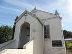 Besides St. John’s Church there is a second church with important historical associations in Bathurst. This one, too, has strong links with the history of the 1820 Settlers.
This church was built in 1832 by Settlers who belonged to the Methodist Church.
Type of site: Church. |
| 9/2/009/0017 | St Stephen's Church, Ostrich Spring, Bathurst District | Type of site: Church. St Stephen's is a fine historical country church, recently restored to full use. It complements the collection of country churches in the Lower Albany Region such as St John's in Bathurst and St Mary's in Cuylerville, and fully warrants recognition. | Bathurst | Bathurst | Register | 33°29′00″S 26°50′00″E | |
| 9/2/009/0019 | Fossil Exposure, Birbury, Bathurst District | The farm Birbury lies several kilometres east of Bathurst, on the road to Trappes Valley. Where the road descends a steep hill near the farm, another gravel road branches to the left amongst the bushes.
Here an outcrop of gravelly limestone which forms th Approx 300m from Birbury farm. Face west. On the western side of the road there is a survey beacon. Just to the right of the beacon there is a fenced right-of-way to the site. |
Bathurst | Bathurst | Provincial Heritage Site | 33°28′45″S 26°55′55″E | |
| 9/2/009/0020 | Settlers Methodist Church, Bathurst Street, Port Alfred | The original Settlers Church on this site was opened in 1827. This church was destroyed by fire during the Frontier War of 1835 and thereafter rebuilt. It was again seriously damaged by the Xhosas in 1846. The church was built in 1823 by the Settlers themselves.
Type of site: Church. |
Port Alfred | Bathurst | Provincial Heritage Site | 33°35′47″S 26°53′16″E | 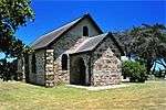 The original Settlers Church on this site was opened in 1827. This church was destroyed by fire during the Frontier War of 1835 and thereafter rebuilt. It was again seriously damaged by the Xhosas in 1846. The church was built in 1823 by the Settlers themselves.
Type of site: Church. |
| 9/2/009/0021 | Port Alfred Railway Station, Port Alfred | This station building, which dates from the early 1880s was presumably erected by George Pauling, the local rail way engineer, for the firm R. Firbank & Co., to whom the building contract was granted.
Type of site: Railway Station. |
Port Alfred | Bathurst | Provincial Heritage Site | 33°35′23″S 26°53′21″E | |
| 9/2/009/0022 | Bleak House, Trappes Street, Bathurst | This double-storey stone building is a typical Bathurst cottage of the 1820-period. | Bathurst | Bathurst | Provincial Heritage Site | 33°30′07″S 26°49′26″E | .jpg) This double-storey stone building is a typical Bathurst cottage of the 1820-period. |
| 9/2/009/0023 | St John's Church, Donkin Street, Bathurst | Bathurst is situated some 16 kilometres from Port Alfred, on the road to Grahamstown. This fine church was built by 1820 settlers. The foundation stone was laid in 1832. It repeatedly served as a place of refuge and fortification during times of war. This is indeed the heart of the area where the 1820 Settlers established themselves.
Type of site: Church. |
Bathurst | Bathurst | Provincial Heritage Site | 33°30′07″S 26°49′10″E |  Bathurst is situated some 16 kilometres from Port Alfred, on the road to Grahamstown. This fine church was built by 1820 settlers. The foundation stone was laid in 1832. It repeatedly served as a place of refuge and fortification during times of war. This is indeed the heart of the area where the 1820 Settlers established themselves.
Type of site: Church. |
| 9/2/009/0024 | Bailey's Beacon and 1820 Toposcope, Bathurst | Col. Jacob Cuyler's Camp stood on this site when he supervised the settlement of the 1820 settlers on their allotments. The Governor, Sir Rufane Donkin also pitched his camp here when he determined the site of the town of Bathurst.
Type of site: Memorial, Beacon Current use: Memorial. |
Bathurst | Bathurst | Provincial Heritage Site | 33°29′46″S 26°50′39″E | Col. Jacob Cuyler's Camp stood on this site when he supervised the settlement of the 1820 settlers on their allotments. The Governor, Sir Rufane Donkin also pitched his camp here when he determined the site of the town of Bathurst.
Type of site: Memorial, Beacon
Current use: Memorial. |
| 9/2/009/0025 | St Mary's Church, Cuylerville, Bathurst District | A gravel road from Bathurst runs parallel with the coast and leads to the mouth of the Great Fish River. About halfway to the Fish River, on the right side of the road, there stands a modest building amongst thick bushes and overshadowed by a giant blue-gum tree. A party of 256 settlers under Lieut. John Baillie R.N. established themselves here in 1820 and named the place Cuylerville. On this site they built a church and school. which also served as a fortification against the repeated attacks of the Xhosas. The p
Type of site: Church. |
Bathurst | Bathurst | Provincial Heritage Site | 33°29′36″S 27°00′49″E | |
| 9/2/009/0026 | Lombard's Post, Bathurst District | The fort was built on a polygonal plan with four main buildings linked by loopholed walls enclosing a central double-storeyed barracks and barn and three double-storeyed dwellings, all linked by high walls. Apart from the farmhouse there were the main bar Lombard's Post was originally granted to Pieter Lombard in 1790 as a loan farm. It served as a military fortification during the Fourth and Sixth Frontier Wars. During the second half of the nineteenth century the farm buildings were fortified by the then owner, Benjamin Keeton.
Type of site: Military/Farm. |
Bathurst | Bathurst | Provincial Heritage Site | 33°32′53″S 26°41′49″E | |
| 9/2/011/0002-078 | 18 Cradock Street, Bedford | Type of site: House
Current use: Residential. No 18 Cradock road Bedford is a good example of a Georgian type house that has remained little altered since its erection in 1855. It remains as an important landmark in a street that has been greatly changed over the years. |
Bedford | Bedford | Register | 32°40′43″S 26°05′05″E | |
| 9/2/011/0003 | 1828 and 1874 Dutch Reformed Churches, Glen Lynden, Bedford District | The older church, which dates from 1828, was erected
in the simple vernacular style. It is T-shaped and, together with the other neighbouring church, which was erected in 1874 in the neo-Gothic style, it forms an important architectural group. Type of site: Church. |
Bedford | Bedford | Provincial Heritage Site | 32°40′57″S 26°06′24″E | 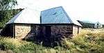 The older church, which dates from 1828, was erected
in the simple vernacular style. It is T-shaped and, together with the other neighbouring church, which was erected in 1874 in the neo-Gothic style, it forms an important architectural group.
Type of site: Church. |
| 9/2/011/0003/001 | 1828 Dutch Reformed Church, Glen Lynden, Bedford District | Type of site: Church. | Bedford | Bedford | Provincial Heritage Site | 32°40′57″S 26°06′24″E |  Type of site: Church. |
| 9/2/011/0003/002 | 1874 Dutch Reformed Church, Glen Lynden, Bedford District | The sturdy stone church at Glen-Lynden was built as a result of co-operation between the Scottish 1820 Settlers and their Dutch-Afrikaner neighbours to meet their need for a church of their own. It was built in 1828 under the leadership of Thomas Pringle
Type of site: Church. |
Bedford | Bedford | Provincial Heritage Site | 32°40′57″S 26°06′24″E | 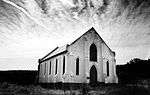 The sturdy stone church at Glen-Lynden was built as a result of co-operation between the Scottish 1820 Settlers and their Dutch-Afrikaner neighbours to meet their need for a church of their own. It was built in 1828 under the leadership of Thomas Pringle
Type of site: Church. |
| 9/2/011/0005 | Old Dairy, Avondale, Bedford District | Bedford | Bedford | Register | 32°33′55″S 26°00′25″E | | |
| 9/2/020/0003 | Hilton Methodist Church complex, Hilton, Cathcart District | Type of site: Church Complex. | Cathcart | Cathcart | Provincial Heritage Site | 32°17′51″S 27°08′32″E | |
| 9/2/020/0003-001 | First Church, Hilton Methodist Church complex, Hilton, Cathcart District | Type of site: Church. | Cathcart | Cathcart | Provincial Heritage Site | 32°17′59″S 27°08′37″E | |
| 9/2/020/0003-002 | Second Church, Hilton Methodist Church complex, Hilton, Cathcart District | Type of site: Church. | Cathcart | Cathcart | Provincial Heritage Site | 32°18′00″S 27°08′00″E | |
| 9/2/020/0003-003 | School, Hilton Methodist Church complex, Hilton, Cathcart District | Type of site: School. | Cathcart | Cathcart | Provincial Heritage Site | 32°18′00″S 27°08′00″E | |
| 9/2/020/0010 | 1853 Milestone, Stone Ridge, Cathcart District | Type of site: Milestone. | Cathcart | Provincial Heritage Site | 32°22′07″S 27°10′45″E | | |
| 9/2/020/0012 | Van Coller Museum, Main Street, Cathcart | Current use: Museum. | Cathcart | Cathcart | Provincial Heritage Site | 32°17′54″S 27°08′46″E | |
| 9/2/020/0013 | Town Hall, Main Street, Cathcart | Type of site: Town Hall
Current use: Satellite Office: Amahlathi municipality office. |
Cathcart | Cathcart | Provincial Heritage Site | 32°31′46″S 27°20′39″E | 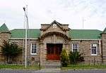 Type of site: Town Hall
Current use: Satellite Office: Amahlathi municipality office. |
| 9/2/020/0014 | Elliots and Cathcart Fruiterers, Main Street, Cathcart | Type of site: Elliots Attonerys. | Cathcart | Cathcart | Provincial Heritage Site | 32°17′53″S 27°08′46″E | |
| 9/2/020/0015 | Standard Bank, Main Street, Cathcart | Type of site: Bank
Current use: Bank. |
Cathcart | Cathcart | Provincial Heritage Site | 32°17′54″S 27°08′47″E | 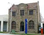 Type of site: Bank
Current use: Bank. |
| 9/2/020/0016 | Cathcart Library, Main Street, Cathcart | Type of site: Library
Current use: Library. |
Cathcart | Cathcart | Provincial Heritage Site | 32°17′54″S 27°08′48″E | 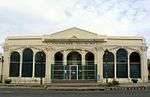 Type of site: Library
Current use: Library. |
| 9/2/020/0017 | Kenya Corner Cottages, Cathcart | Current use: Satellite office: Tourism information centre. | Cathcart | Cathcart | Provincial Heritage Site | 32°23′45″S 27°12′39″E | |
| 9/2/020/0018/001 | Settler fortification, Hilton, Cathcart District | . | Cathcart | Cathcart | Provincial Heritage Site | 32°18′00″S 27°08′00″E | |
| 9/2/020/0018/002 | Settler cottage, Hilton, Cathcart District | . | Cathcart | Cathcart | Provincial Heritage Site | 32°18′00″S 27°08′00″E | |
| 9/2/024/0003 | Old Congregational Church, 1 High Street, Cradock | Gothic revival church with rectangular plan, vestry to side. Entrance at front on axis. Lancet windows. ventilation gablets. This neo-Gothic church was erected in 1853 by the Revd. Robert Barry Taylor, the then missionary in Cradock of the London Mission Society. It is a replica of the Harpenden Chapel in England.
Type of site: Church Current use: Vacant. The property is located 250km from Port Elizabeth. The property is adjacent to Tam's Built It Builders Yard and across from retail trade i.e Ellerines Furniture Store, Ok Bazaars and the Inland Revenue Office. |
Cradock | Cradock | Provincial Heritage Site | 32°10′22″S 25°37′08″E | |
| 9/2/024/0009 | Olive Schreiner Sarcophagus, Buffelskop, Cradock District | Type of site: Grave. | Cradock | Cradock | Provincial Heritage Site | 32°16′50″S 25°37′22″E | |
| 9/2/024/0010 | Doornhoek homestead, Mountain Zebra National Park, Cradock District | . | Cradock | Cradock | Provincial Heritage Site | 32°13′25″S 25°28′46″E | |
| 9/2/024/0011 | Old Dutch Reformed Parsonage, 87 High Street, Cradock | Symmetrical single-storey ridged building and outbuilding, with end gable lean to at back, with stoep to front. Original front door and fanlight. Louvres and 12/12 sash windows outside. Staircase to solder and bakoond. This property was probably granted to the Church Council of the local D.R. Church early in the 19th century, although the building of the parsonage and cart shed was only commenced in 1848. The parsonage, which was used as such until 1904, is mainly assoc Architectural style: Cape Dutch.
Type of site: Pastorie. Current use: Museum. |
Cradock | Cradock | Provincial Heritage Site | 31°10′14″S 25°37′02″E | |
| 9/2/024/0012 | Dutch Reformed Church, Stockenstroom Street, Cradock | Impressive neo-classical church based on Sir Christopher Wren's design for St Martin in the Field, Trafalgar Square, London. Fine detailing in stone, especially clock tower. Impressive pedimented stepped entrance supported by stone columns. This church building is situated on the same site where the first Dutch Reformed Church in Cradock was built between 1821 and 1824. Construction work on the present church commenced in January 1864 and it was consecrated on 10 September 1868.
Type of site: Church. Current use: Religious. |
Cradock | Cradock | Provincial Heritage Site | 32°10′09″S 25°37′01″E | 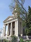 Impressive neo-classical church based on Sir Christopher Wren's design for St Martin in the Field, Trafalgar Square, London. Fine detailing in stone, especially clock tower. Impressive pedimented stepped entrance supported by stone columns. This church building is situated on the same site where the first Dutch Reformed Church in Cradock was built between 1821 and 1824. Construction work on the present church commenced in January 1864 and it was consecrated on 10 September 1868.
Type of site: Church.
Current use: Religious. |
| 9/2/024/0013 | 38 Bree Street, Cradock | Symmetrical single-storey ridged building extended to side, with central and end gables. Stoep to front. T plan. Architectural style: Cape Dutch. This Cape Dutch house with its simple concavo-convex front gable dates from the eighteen thirties.
Type of site: Residence. Current use: Residential. |
Cradock | Cradock | Provincial Heritage Site | 32°10′28″S 25°37′07″E | 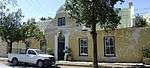 Symmetrical single-storey ridged building extended to side, with central and end gables. Stoep to front. T plan. Architectural style: Cape Dutch. This Cape Dutch house with its simple concavo-convex front gable dates from the eighteen thirties.
Type of site: Residence.
Current use: Residential. |
| 9/2/024/0014 | 38 Stockenstroom Street, Cradock | Symmetrical single-storey ridged building with end gable with verandah to front.
Type of site: Residence Current use: Empty. |
Cradock | Cradock | Provincial Heritage Site | 32°10′15″S 25°37′05″E | |
| 9/2/024/0015 | Olive Schreiner House, 9 Cross Street, Cradock | Single-storey Karoo-style flat-roofed building with stoep to front.
Type of site: Residence Current use: Museum. |
Cradock | Cradock | Provincial Heritage Site | 32°10′24″S 25°37′04″E | 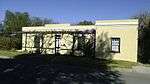 Single-storey Karoo-style flat-roofed building with stoep to front.
Type of site: Residence
Current use: Museum. |
| 9/2/026/0003 | Gately House, 1 Park Gates Road, East London | (a) Single storied plastered brick structure over stone foundation. Corrugated iron roof. Verandah – 3 sides. Doors and windows – wood. This house was completed in 1878 and belonged to John Gately, a well-known local dealer and member of the Municipality of East London. The building which is at present a museum, contains a unique collection of Victorian furniture which belonged to Gately.
Current use: East London Museum Board of Trustees. |
East London, CBD | East London | Provincial Heritage Site | 33°01′07″S 27°54′06″E | |
| 9/2/026/0005 | City Hall, Oxford Street, East London | Double storied plastered brick. Corrugated iron pitched roof behind parapets. Doors and windows- wood. Special feature: Clock tower and copper clad Spire. Architectural style: Victorian Renaissance. These three buildings, with their Victorian, neo-classical and Renaissance features, form an integral part of the historical and architectural core of East London. Moreover, each of these buildings can, in its own right, be described as unique.
Type of site: City Hall. Current use: Mayor's Parlour/Council Chamber/Conference Centre. |
East London, CBD | East London | Provincial Heritage Site | 33°00′53″S 27°54′14″E |  Double storied plastered brick. Corrugated iron pitched roof behind parapets. Doors and windows- wood. Special feature: Clock tower and copper clad Spire. Architectural style: Victorian Renaissance. These three buildings, with their Victorian, neo-classical and Renaissance features, form an integral part of the historical and architectural core of East London. Moreover, each of these buildings can, in its own right, be described as unique.
Type of site: City Hall.
Current use: Mayor's Parlour/Council Chamber/Conference Centre. |
| 9/2/026/0006 | Old Methodist Church, Ncera, East London District | Type of site: Church. | East London | East London | Provincial Heritage Site | 33°08′33″S 27°34′13″E | |
| 9/2/026/0007 | Bronze cannon salvaged from the wreck of the Nossa Senhora de Atalaia do Pinheiro | Type of site: Gun. | East London | East London | Heritage Object | | |
| 9/2/026/0007-001 | Bronze Bocarro Cannon, salvaged from the wreck of the Nossa Senhora de Atalaia do Pinheiro | Type of site: Gun. | East London | East London | Heritage Object | | |
| 9/2/026/0007-002 | Bronze Feyo naval cannon, salvaged from the wreck of the Nossa Senhora de Atalaia do Pinheiro | Type of site: Gun. | East London | East London | Heritage Object | | |
| 9/2/026/0007-003 | Bronze cannon, salvaged from the wreck of the Nossa Senhora de Atalaia do Pinheiro | Type of site: Gun. | East London | East London | Heritage Object | | |
| 9/2/026/0009 | West Bank Post Office, Bank Street, East London | Type of site: Post Office. | East London, West Bank | East London | Provincial Heritage Site | 33°01′53″S 27°54′36″E | 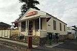 Type of site: Post Office. |
| 9/2/026/0010 | Old Powder Magazine, Fort Glamorgan, East London | The powder magazine of Fort Glamorgan nestles against the hill on the west bank of the Buffalo River, overlooking the harbour of East London.
The Seventh Xhosa War, also known as the War of the Axe, broke out in 1846. Type of site: Powder Magazine. |
East London, West Bank | East London | Provincial Heritage Site | 33°01′58″S 27°53′49″E | |
| 9/2/026/0011 | Lower Needs Camp, East London District | Upper and Lower Need’s Camp are two lime quarries beside the main road from King William’s Town to East London.
Upper Need’s Camp lies on a hill just within the Divisional boundary of King William’s Town. |
East London | Provincial Heritage Site | 33°00′50″S 27°39′00″E | | |
| 9/2/026/0012 | Queens Park, Beaconsfield Road, East London | The original part of Queen's Park was donated to the inhabitants at East London in about 1880 by Mr Gately for use as a public park. This park is of particular botanical interest. | East London, CBD | East London | Provincial Heritage Site | 33°57′35″S 25°36′14″E | 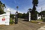 The original part of Queen's Park was donated to the inhabitants at East London in about 1880 by Mr Gately for use as a public park. This park is of particular botanical interest. |
| 9/2/026/0013 | Cuthbert's Building, 110 Oxford Street, East London | Three storied plus rooms in roof space. Plastered brickwork structural iron framing with wood floors. The imposing treble-storeyed building, with its Flemish Renaissance gables, was designed by the architects Parker and Forsyth of Cape Town and erected in 1901 under the supervision of J. Pender West, of the same firm, for W.M. Cuthbert.
Architectural style: Victorian neo-classic. Current use: Offices over shops. |
East London, CBD | East London | Provincial Heritage Site | 32°00′54″S 27°54′12″E | 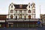 Three storied plus rooms in roof space. Plastered brickwork structural iron framing with wood floors. The imposing treble-storeyed building, with its Flemish Renaissance gables, was designed by the architects Parker and Forsyth of Cape Town and erected in 1901 under the supervision of J. Pender West, of the same firm, for W.M. Cuthbert.
Architectural style: Victorian neo-classic.
Current use: Offices over shops. |
| 9/2/026/0014 | Old Public Library, Argyle Street, East London | Single storied plastered brick. Corrugated iron pitched roofing behind parapets. Doors and windows – wood/iron. Special feature: Doric column portico. Architectural style: Neo-classical.
Type of site: Library Current use: Offices and conference room. These three buildings, with their Victorian, neo-classical and Renaissance features, form an integral part of the historical and architectural core of East London. Moreover, each of these buildings can, in its own right, be described as unique. |
East London, CBD | East London | Provincial Heritage Site | 33°00′51″S 27°54′18″E | 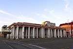 Single storied plastered brick. Corrugated iron pitched roofing behind parapets. Doors and windows – wood/iron. Special feature: Doric column portico. Architectural style: Neo-classical.
Type of site: Library
Current use: Offices and conference room.
These three buildings, with their Victorian, neo-classical and Renaissance features, form an integral part of the historical and architectural core of East London. Moreover, each of these buildings can, in its own right, be described as unique. |
| 9/2/026/0015 | Ann Bryant Art Gallery, St Lukes Road, East London | These three buildings, with their Victorian, neo-classical and Renaissance features, form an integral part of the historical and architectural core of East London. Moreover, each of these buildings can, in its own right, be described as unique. | East London | East London | Provincial Heritage Site | 33°00′03″S 27°53′51″E | 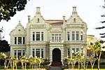 These three buildings, with their Victorian, neo-classical and Renaissance features, form an integral part of the historical and architectural core of East London. Moreover, each of these buildings can, in its own right, be described as unique. |
| 9/2/026/0016 | Old Standard Bank Building, 64 Terminus Street, East London | The Provincial Building which was originally the old Standard Bank Building, is a fine example of Neo-Renaissance revivalism which covers an area of 1222 square metres and is situated on a very prominent corner site. It was erected in two stages. The original portion of this double-storeyed building which was situated in Terminus Street, was erected in 1900 on Lot No. 11. The property was then occupied as regional branch for the Standard Bank of South Africa. In 1926 it decided to extend and the building extended onto Lot 12 in 1927.
Architectural style: Classical. Type of site: Bank Current use: Office building. |
East London, CBD | East London | Provincial Heritage Site | 33°01′01″S 27°54′21″E | 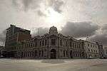 The Provincial Building which was originally the old Standard Bank Building, is a fine example of Neo-Renaissance revivalism which covers an area of 1222 square metres and is situated on a very prominent corner site. It was erected in two stages. The original portion of this double-storeyed building which was situated in Terminus Street, was erected in 1900 on Lot No. 11. The property was then occupied as regional branch for the Standard Bank of South Africa. In 1926 it decided to extend and the building extended onto Lot 12 in 1927.
Architectural style: Classical.
Type of site: Bank
Current use: Office building. |
| 9/2/026/0017 | Wool Exchange Building, Rhodes University, 50 Church Street, East London | Double storied – brick walling plastered. Pitched roof/Gables. Doors and windows – Hardwood. Decorative boundary walls. Original use: Wool Exchange – 1929. Architectural style: Classical.
Type of site: University. Current use: University Administration and Lecture. |
East London, CBD | East London | Provincial Heritage Site | 33°01′13″S 27°54′25″E |  Double storied – brick walling plastered. Pitched roof/Gables. Doors and windows – Hardwood. Decorative boundary walls. Original use: Wool Exchange – 1929. Architectural style: Classical.
Type of site: University.
Current use: University Administration and Lecture. |
| 9/2/026/0028 | Red House, Red House Avenue, East London | The Redhouse is a fine example of a Mediterranean type mansion from the second decade of this century. It is an imposing and aesthetically pleasing building that would stand proud in any centre. | East London, Vincent | East London | Provincial Heritage Site | 32°59′01″S 27°55′00″E | |
| 9/2/026/0031 | Hood Point Lighthouse, East London | Type of site: Lighthouse
Current use: Lighthouse. The Hood Point Lighthouse is a fine example of its type and has performed sterling service continually for one hundred years. |
East London, West Bank | East London | Provincial Heritage Site | 33°02′26″S 27°53′55″E | 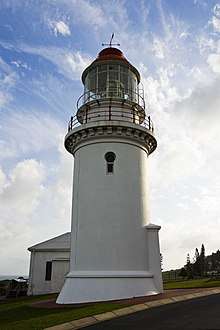 Type of site: Lighthouse
Current use: Lighthouse.
The Hood Point Lighthouse is a fine example of its type and has performed sterling service continually for one hundred years. |
| 9/2/026/0032 | Cambridge Primary School, Brabant Street, East London | Type of site: School
Current use: School. The Cambridge Preparatory School, one of the earliest educational institutions still extant in East London, was the first school to be erected in the municipality of Cambridge. The school still serves the same function and remains in good condition. |
East London, Cambridge | East London | Register | 32°58′27″S 27°53′13″E | |
| 9/2/026/0034 | Customs and Excise Building, East London | . | East London | East London | Provincial Heritage Site | 33°01′22″S 27°54′24″E | |
| 9/2/026/0035 | West Bank High School, Hood Street, East London | Type of site: School. | East London, West Bank | East London | Register | 33°02′04″S 27°54′21″E | |
| 9/2/028/0004 | Post Retief, Fort Beaufort District | Post Retief was designed by Major C. Selwyn and built, in 1836 to protect the Winterberg District. The farm on which this fort is situated originally belonged to the Voortrekker leader Piet Retief and sections of the old walls of the Retief home are included.
Type of site: Military. |
Fort Beaufort | Fort Beaufort | Provincial Heritage Site | 32°41′13″S 26°18′47″E | |
| 9/2/028/0006 | Fort Beaufort Museum, 44 Durban Street, Fort Beaufort | The historic Officers' Mess dates from about 1830 and is one of the oldest existing buildings in Fort Beaufort. It is closely linked with the history of the town as well as with the military history of the Eastern Cape.
Type of site: Officers' Mess Current use: Museum. |
Fort Beaufort | Fort Beaufort | Provincial Heritage Site | 32°46′42″S 26°37′50″E |  The historic Officers' Mess dates from about 1830 and is one of the oldest existing buildings in Fort Beaufort. It is closely linked with the history of the town as well as with the military history of the Eastern Cape.
Type of site: Officers' Mess
Current use: Museum. |
| 9/2/028/0007 | Old Watermill, Mill Bank, Fort Beaufort District | Type of site: Water Mill. | Fort Beaufort | Provincial Heritage Site | 32°44′50″S 26°35′55″E | | |
| 9/2/028/0009 | Victoria Bridge, Bridge Street, Fort Beaufort | This bridge carries the Queen's Road, at that time an important military road, across the Kat River, It was designed by Major C. J. Selwyn, R.E., and completed towards the end of 1843 or early in 1844.
Type of site: Bridge. Current use: Bridge. |
Fort Beaufort | Fort Beaufort | Provincial Heritage Site | 32°47′00″S 26°37′26″E | 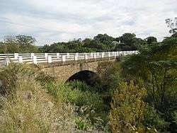 This bridge carries the Queen's Road, at that time an important military road, across the Kat River, It was designed by Major C. J. Selwyn, R.E., and completed towards the end of 1843 or early in 1844.
Type of site: Bridge.
Current use: Bridge. |
| 9/2/028/0010 | Old Military Hospital, Bell Street, Fort Beaufort | This U-shaped hospital building, which was erected shortly before the Seventh Frontier War (1846-1847), was designed by Captain J. E. Walpole of the Royal Engineers. In the 1870s the British Army vacated the premises.
Type of site: Hospital Current use: Stores. |
Fort Beaufort | Fort Beaufort | Provincial Heritage Site | 32°46′49″S 26°37′59″E | |
| 9/2/028/0011 | Military Museum, 20 Bell Street, Fort Beaufort | The Officers' Quarters, Fort Beaufort, were built in 1849. Together with the neighbouring Martello tower, the officers' Quarters form a unique historical and architectural group which is extremely worthy of preservation.
Current use: Museum. |
Fort Beaufort | Fort Beaufort | Provincial Heritage Site | 32°46′44″S 26°38′07″E | 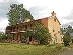 The Officers' Quarters, Fort Beaufort, were built in 1849. Together with the neighbouring Martello tower, the officers' Quarters form a unique historical and architectural group which is extremely worthy of preservation.
Current use: Museum. |
| 9/2/028/0012 | Martello Tower, 20 Bell Street, Fort Beaufort | Fort Beaufort is situated in a bend of the Kat River and owes its origin to the establishment of a military post there in 1822 by Colonel Scott, mainly for the purpose of countering continual raids by Makomo.
Type of site: Martello Tower. Current use: Museum. |
Fort Beaufort | Fort Beaufort | Provincial Heritage Site | 32°46′44″S 26°38′07″E | 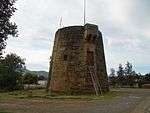 Fort Beaufort is situated in a bend of the Kat River and owes its origin to the establishment of a military post there in 1822 by Colonel Scott, mainly for the purpose of countering continual raids by Makomo.
Type of site: Martello Tower.
Current use: Museum. |
| 9/2/028/0013 | St John's Church, Post Retief, Fort Beaufort District | Type of site: Church. | Fort Beaufort | Fort Beaufort | Provincial Heritage Site | 32°18′19″S 26°18′59″E | |
| 9/2/028/0016 | Sundial, Fort Beaufort Museum, 44 Durban Street, Fort Beaufort | The village of Seymour, also on the Kat River, lies barely 11 km east of Balfour and not far from Fort Armstrong. It too owes its origin to a military post, namely Eland’s Post.
Type of site: Sundial. |
Fort Beaufort | Fort Beaufort | Heritage Object | 32°46′38″S 26°37′47″E | |
| 9/2/028/0019 | Sipton Manor, Fort Beaufort District | . | Fort Beaufort | Fort Beaufort | Provisional Protection | 32°47′11″S 26°31′12″E | |
| 9/2/034/0003 | Irrigation tunnel, Hankey District | At first irrigation-furrows leading from the Klein River were dug to irrigate the fields in the immediate vicinity of Hankey, but William Philip had a far more ambitious plan in mind.
Type of site: Tunnel. The old irrigation tunnel and the water furrow are a notable engineering work of the pioneer farmers under the guidance of the Rev. William Philip. They were completed in 1844. |
Hankey | Hankey | Provincial Heritage Site | 33°49′18″S 24°50′53″E | |
| 9/2/034/0004 | Sarah Baartmann Site, R331Hankey, Kouga Municipality | The site has spiritual, cultural, social, and historical significance.
The treatment of Sarah Baartman during her life and after her death speaks of suffering, dispossession, sadness and loss of dignity, culture, community, language and life. |
Hankey | Hankey | National Heritage Site | 33°50′13″S 24°53′05″E |  The site has spiritual, cultural, social, and historical significance.
The treatment of Sarah Baartman during her life and after her death speaks of suffering, dispossession, sadness and loss of dignity, culture, community, language and life. |
| 9/2/041/0003 | Magistrate's Court and Post Office, Hofmeyr | Type of site: Courthouse and Post Office. | Hofmeyr | Hofmeyr | Provincial Heritage Site | 31°39′12″S 25°48′13″E | 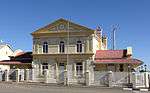 Type of site: Courthouse and Post Office. |
| 9/2/044/0004 | Seal Point Lighthouse, Cape St Francis, Humansdorp District | The Cape St Francis lighthouse, which is an 80 feet high cylindrical masonry structure which stands on a rock foundation, is one of the highest lighthouses in South Africa and is from a navigational point of view very important to shipping. Building commenced in 1876.
Type of site: Lighthouse. |
Humansdorp | Provincial Heritage Site | 34°12′44″S 24°50′12″E |  The Cape St Francis lighthouse, which is an 80 feet high cylindrical masonry structure which stands on a rock foundation, is one of the highest lighthouses in South Africa and is from a navigational point of view very important to shipping. Building commenced in 1876.
Type of site: Lighthouse. | |
| 9/2/044/0006 | Moravian Mission Complex, Clarkson, Humansdorp District | Type of site: Mission Station. | Clarkson | Humansdorp | Provincial Heritage Site | 34°00′36″S 24°20′48″E | |
| 9/2/044/0006-001 | Church, Moravian Mission Complex, Clarkson, Humansdorp District | Type of site: Church. | Clarkson | Humansdorp | Provincial Heritage Site | 34°00′36″S 24°20′48″E | |
| 9/2/044/0006-002 | Parsonage, Moravian Mission Complex, Clarkson, Humansdorp District | Type of site: Parsonage. | Clarkson | Humansdorp | Provincial Heritage Site | 34°00′36″S 24°20′48″E | |
| 9/2/044/0006-003 | School, Moravian Mission Complex, Clarkson, Humansdorp District | Type of site: School. | Clarkson | Humansdorp | Provisional Protection | 34°00′36″S 24°20′48″E | |
| 9/2/044/0006-004 | Church offices, Moravian Mission Complex, Clarkson, Humansdorp District | Type of site: Church Offices. | Clarkson | Humansdorp | Provincial Heritage Site | 34°00′36″S 24°20′48″E | |
| 9/2/044/0006-005 | Mission store, Moravian Mission Complex, Clarkson, Humansdorp District | Type of site: Shop. | Clarkson | Humansdorp | Provincial Heritage Site | 34°00′36″S 24°20′48″E | |
| 9/2/044/0006-006 | Cemetery, Moravian Mission Complex, Clarkson, Humansdorp District | Type of site: Cemetery. | Clarkson | Humansdorp | Provincial Heritage Site | 34°00′36″S 24°20′48″E | |
| 9/2/044/0006-007 | Memorial to Pastor Nauhaus, Moravian Mission Complex, Clarkson, Humansdorp District | Type of site: Memorial. | Clarkson | Humansdorp | Provincial Heritage Site | 34°00′36″S 24°20′48″E | |
| 9/2/044/0006-008 | Church bell, Moravian Mission Complex, Clarkson, Humansdorp District | Type of site: Bell. | Clarkson | Humansdorp | Provincial Heritage Site | 34°00′36″S 24°20′48″E | |
| 9/2/044/0007 | School, Moravian Mission, Thornham, Humansdorp District | Type of site: School. The old school at Thornham is one of the oldest structures in the area and despite its basic simplicity, is worthy of recognition. | Humansdorp | Humansdorp | Register | 34°01′59″S 24°45′58″E | |
| 9/2/045/0005 | Dutch Reformed Church, Voortrekker Street, Indwe | Type of site: Church
Current use: Church : Dutch Reformed. The Dutch Reformed Church in Indwe is one of the last large sandstone churches to be erected in the North Eastern Cape. It holds a very prominent position within the town itself. |
Indwe | Indwe | Register | 31°28′02″S 27°20′20″E | 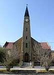 Type of site: Church
Current use: Church : Dutch Reformed.
The Dutch Reformed Church in Indwe is one of the last large sandstone churches to be erected in the North Eastern Cape. It holds a very prominent position within the town itself. |
| 9/2/046/0007 | Dutch Reformed Church, 23 Main Street, Jansenville | Type of site: Church. | Jansenville | Jansenville | Provincial Heritage Site | 32°56′37″S 24°39′50″E | 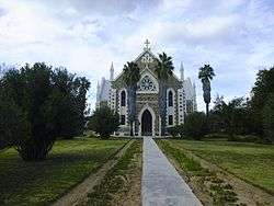 Type of site: Church. |
| 9/2/050/0004 | 5 Hood Street, King William's Town | It is a picturesque, solidly-constructed small double-storey residence of stone and brick, strongly resembling an eighteenth-century English farmhouse. The building has several unusual features which make it of special architectural interest. These feature The Military Reserve complex was largely built by the Imperial Government on the east bank of the Buffalo River during the years 1848-1866. During those years King William's Town was the most important town on the Frontier and also served as capital of Br. This mid-nineteenth-century double-storey house is closely associated with the military history of King William's Town at a stage when the town was at the centre of the Frontier Wars. The neo-Gothic windows and Victorian wooden balcony are particularly notable. | King William's Town | King William's Town | Provincial Heritage Site | 32°52′11″S 27°23′14″E | |
| 9/2/050/0005 | Von Ronow House and Moser Cottage, Berlin, King William's Town District | Both the historic houses on this site are typical pioneer houses of the German Settlers who settled in the Eastern Province in the 1850s. | King William's Town | King William's Town | Provincial Heritage Site | 32°51′19″S 27°35′11″E | |
| 9/2/050/0006 | Brownlee Congregational Church, Reserve Road, King William's Town | This building was erected in 1860 by the Rev. John Brownlee, missionary and founder of King William’s Town.
Type of site: Church Current use: Church. This building was erected in 1860 by the Rev. John Brownlee, missionary and founder of King William's Town. |
King William's Town | King William's Town | Provincial Heritage Site | 32°51′51″S 27°32′48″E | |
| 9/2/050/0007 | Old Residency, Reserve Road, King William's Town | Single-storey building, built with stone and plastered brick under thatch roof. Windows are sash windows with timber louvre shutters. The floors are yellowwood timber flooring and concrete. The historic Residency was erected around 1846 and is situated on the spot where the London Missionary Society’s mission station was built by John Brownlee after his arrival in 1826. This building is closely linked to the history of King William's Town.
Type of site: Residency Previous use: Vacant. Current use: Vacant. |
King William's Town, King William's Town | King William's Town | Provincial Heritage Site | 32°57′48″S 27°27′45″E | 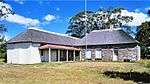 Single-storey building, built with stone and plastered brick under thatch roof. Windows are sash windows with timber louvre shutters. The floors are yellowwood timber flooring and concrete. The historic Residency was erected around 1846 and is situated on the spot where the London Missionary Society’s mission station was built by John Brownlee after his arrival in 1826. This building is closely linked to the history of King William's Town.
Type of site: Residency Previous use: Vacant.
Current use: Vacant. |
| 9/2/050/0008 | Holy Trinity Church, Prince Alfred's Square, King William's Town | ASYMMETRICAL PLAN BELOW A STEEP RIDGED, PITCHED, PARAPET GABLED ROOF WITH SQUAT TOWER ADJACENT TO CHURCH. AT THE GABLE END FACING THE STREET A VARIETY OF SMALLER GABLE ENDED PARTS HAVE BEEN ADDED TO THE CHURCH.
Type of site: Church Current use: Anglican Church. |
King William's Town | King William's Town | Provincial Heritage Site | 32°59′20″S 27°28′33″E | |
| 9/2/050/0009 | Sun Building, Alexandra Road, King William's Town | Asymmetrical, double storey, L-shaped plan under ridged, pitched and hipped roof. Entry at corner marked by ornate tower with a copper dome. Fenestration makes use of nine-pane casement windows, nine-pane middle-swing windows and stained glass windows.
Type of site: Commercial Current use: Financial Institution. |
King William's Town | King William's Town | Provincial Heritage Site | 32°52′38″S 27°23′28″E | |
| 9/2/050/0010/002 | Old Powder Magazine, Military Reserve, King William's Town | TWO SQUARE PLANNED BUILDINGS BELOW A RIDGED AND PITCHED GABLED BUILDING WITH NARROW SLITS IN THE WALLS AND HIDDEN TIMBER DOORS. THE TWO BUILDINGS ARE COMPLETELY SURROUNDED WITH HIGH STONE WALLS. EACH BUILDING STANDS IN ITS OWN COURTYARD. This powder magazine is one of the largest and best preserved examples of its kind in South Africa. It was probably erected in two stages, namely between 1852 and 1862 and between 1864 and 1875.
Type of site: Powder Magazine. |
King William's Town | King William's Town | Provincial Heritage Site | 32°57′48″S 27°27′45″E | |
| 9/2/050/0010/003 | Old Commissariat Store, Military Reserve, King William's Town | This L-shaped stone building was completed in 1849, shortly before the outbreak of the Eighth Frontier War (1850-1853). It was also used in times of peace, for example to store corn in 1857 during the so-called Xhosa Suicide. | King William's Town | King William's Town | Provincial Heritage Site | 32°57′48″S 27°27′45″E | |
| 9/2/050/0010/004 | Old Officers' Mess, Military Reserve, King William's Town | This U-shaped building was erected largely in 1849 as an Officers' Mess at a time when King William's Town formed the centre of the Frontier Wars and accommodated a large garrison. The building was used as a mess until 1884.
Type of site: Mess. |
King William's Town | King William's Town | Provincial Heritage Site | 32°57′48″S 27°27′45″E | |
| 9/2/050/0011 | Stead Wing, Kaffrarian Museum, Alexandra Road, King William's Town | SQUARE SHAPED BUILDING WITH INTERIOR COURTYARD BELOW A RIDGED AND HIPPED ROOF WITH 3 CHIMNEY STACKS VISIBLE. THE STRAIGHT ROOFED FRONT VERANDAH IS SUPPORTED BY TIMBER COLUMNSON A STONE BASE AND FINISHED OFF WITH CAST IRON BALUSTRADES. THE ENTRANCE IS FO This building was first occupied in 1877 and accommodated various Government departments. The building has an imposing clock tower with a memorial clock, which was installed in memory of John Brownlee, first missionary and founder of King William's Town.
Type of site: House Current use: Private house. |
King William's Town | King William's Town | Provincial Heritage Site | 32°52′39″S 27°23′30″E | 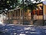 SQUARE SHAPED BUILDING WITH INTERIOR COURTYARD BELOW A RIDGED AND HIPPED ROOF WITH 3 CHIMNEY STACKS VISIBLE. THE STRAIGHT ROOFED FRONT VERANDAH IS SUPPORTED BY TIMBER COLUMNSON A STONE BASE AND FINISHED OFF WITH CAST IRON BALUSTRADES. THE ENTRANCE IS FO This building was first occupied in 1877 and accommodated various Government departments. The building has an imposing clock tower with a memorial clock, which was installed in memory of John Brownlee, first missionary and founder of King William's Town.
Type of site: House
Current use: Private house. |
| 9/2/050/0012 | Magistrate's Court, Alexandra Road, King William's Town | SYMMETRICAL PLAN BELOW A RIDGED AND HIPPED ROOF WITH A CENTRAL, 3 ARCHED, DOUBLE VOLUME ENTRANCE PORCH WITH AN ORNATE CLOCK TOWER ABOVE IT. FENESTRATION MAKES USE OF 4 PANE SASH WINDOWS WITH RAISED PLASTER SURROUNDS AND ARCHED FANLIGHTS. THE CENTRAL ENT This building was first occupied in 1877 and accommodated various Government departments. The building has an imposing clock tower with a memorial clock, which was installed in memory of John Brownlee, first missionary and founder of King William's Town.
Type of site: Courthouse. Current use: Magistrate's Court. |
King William's Town | King William's Town | Provincial Heritage Site | 33°03′00″S 27°31′25″E | 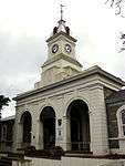 SYMMETRICAL PLAN BELOW A RIDGED AND HIPPED ROOF WITH A CENTRAL, 3 ARCHED, DOUBLE VOLUME ENTRANCE PORCH WITH AN ORNATE CLOCK TOWER ABOVE IT. FENESTRATION MAKES USE OF 4 PANE SASH WINDOWS WITH RAISED PLASTER SURROUNDS AND ARCHED FANLIGHTS. THE CENTRAL ENT This building was first occupied in 1877 and accommodated various Government departments. The building has an imposing clock tower with a memorial clock, which was installed in memory of John Brownlee, first missionary and founder of King William's Town.
Type of site: Courthouse.
Current use: Magistrate's Court. |
| 9/2/050/0013 | Deeds Office, Alexandra Road, King William's Town | SYMMETRICAL, U-SHAPED PLAN BELOW A RIDGED AND HIPPED ROOF WITH A CENTRAL ENTRANCE. FENESTRATION MAKES USE OF 12 PANE CASEMENT WINDOWS WITH 10 PANE STRAIGHT FANLIGHTS. ORNATE CORNICE BELOW GUTTER AND 2 HIGH CHIMNEY STACKS VISIBLE ON THE ROOF.
Type of site: Commercial Current use: Deeds Offices. |
King William's Town | King William's Town | Provincial Heritage Site | 33°03′27″S 27°31′25″E | |
| 9/2/050/0014/001 | Daines Wing, Kaffrarian Museum, Alexandra Road, King William's Town | DOUBLE STOREY ELONGATED PLAN BELOW A RIDGED AND GABLED ROOF WITH THE ENTRANCE IN THE GABLE. ENTRANCE IS ENHANCED BY HEAVY COLUMNS AND PLASTER MOULDINGS. COLUMNS SUPPORT A VERY HEAVY PEDIMENT. FENESTRATION MAKES USE OF 2 PANE CASEMENT WINDOWS WITH RAISE The Kaffrarian Museum originated from the Natural History Society, which was founded in King William's Town in 1884. The original museum building, which was designed by the architect P. E. Treeby of Johannesburg and opened by Mrs James Weir
Type of site: Community Current use: Museum. |
King William's Town | King William's Town | Provincial Heritage Site | 32°52′37″S 27°23′29″E | |
| 9/2/050/0014/002 | Natural History Wing, Kaffrarian Museum, Albert Road, King William's Town | Elongated plan below ridged and parapet gabled roof with ornate entrance gable on side of the building. Timber double doors from the entrance and is decorated with plaster moulding surrounds. Fenestration makes use of large 12 pane arched windows.
Type of site: Community. Current use: Museum of Natural History. |
King William's Town | King William's Town | Provincial Heritage Site | 32°52′36″S 27°23′32″E | |
| 9/2/050/0015 | Lonsdale Chambers, Taylor Street, King William's Town | This double-storey building with its predominantly neo-Classical features was designed and built in 1924 by the architects Cordreaux, Farrow and Stocks. The building was named after James Faunce Lonsdale | King William's Town | King William's Town | Provincial Heritage Site | 32°52′42″S 27°23′24″E | |
| 9/2/050/0016 | British Kaffrarian Savings Bank, MacLean Square, King William's Town | The British Kaffrarian Savings Bank building was erected in 1908. It is an architecturally interesting building which portrays the architecture of the period 1900-1910. It also lends character to Maclean Square on which it is situated.
Type of site: Bank Current use: Nedbank. |
King William's Town | King William's Town | Provincial Heritage Site | 32°52′43″S 27°23′23″E | 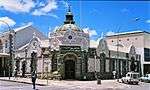 The British Kaffrarian Savings Bank building was erected in 1908. It is an architecturally interesting building which portrays the architecture of the period 1900-1910. It also lends character to Maclean Square on which it is situated.
Type of site: Bank
Current use: Nedbank. |
| 9/2/050/0017 | Old Railway station, Alexandra Road, King William's Town | The building is a simple elongated rectangle in shape and is remarkable for the magnificent stonework, two varieties having been used, for walling and window and door surrounds respectively. The interior has been altered to suit the present use. The exterior. This stone building was officially opened as a railway station on 1 May 1877. After the relocation it was acquired in 1933 by the De Vos Malan Primary School. The building is now used as School Board offices.
Type of site: Railway station. Current use: Public Service Commission. |
King William's Town | King William's Town | Provincial Heritage Site | 33°06′09″S 27°33′36″E | |
| 9/2/050/0018 | Victoria Drill Hall, Queens Road, King William's Town | This Victorian building with its neo-Classical features was designed by J. Laughton and was named after Queen Victoria to commemorate her sixtieth year as Queen of the British Empire. The cornerstone of the building was laid on 21 June 1897.
Type of site: Drill Hall. |
King William's Town | King William's Town | Provincial Heritage Site | 32°52′39″S 27°23′34″E | |
| 9/2/050/0019 | Sutton House, Queens Road, King William's Town | The corner-stone of Sutton House was laid on 6 September 1877 by the Governor of the Cape Colony, Sir Henry Bartle Frere. The building was officially opened on 17 December 1878 and named after the Rev. J. G. Sutton, Headmaster of Dale College from 1890.
Current use: Hutton & Cook Attorney, Old Mutual Offices, AW Administrators & The Rock (pub). |
King William's Town | King William's Town | Provincial Heritage Site | 33°02′51″S 27°33′11″E | |
| 9/2/050/0021 | Old Royal Engineers Officers' Mess, Reserve Road, King William's Town | Type of site: Mess. | King William's Town | King William's Town | Provincial Heritage Site | 32°57′48″S 27°27′45″E | |
| 9/2/050/0022 | Old Blacksmiths shop, Oak Street, King William's Town | Type of site: Blacksmith
Current use: Correctional Services: Logistics. |
King William's Town | King William's Town | Provincial Heritage Site | 32°57′13″S 27°26′44″E | |
| 9/2/050/0023 | Old Military Hospital, King William's Town | Type of site: House. | King William's Town | King William's Town | Provincial Heritage Site | 32°57′48″S 27°27′45″E | |
| 9/2/050/0024 | Dale College Boys' Primary School, Albert Road, King William's Town | SYMMETRICAL PLAN BELOW RIDGED, PITCHED, GABLED AND HIPPED ROOFS. THE CENTRAL ENTRANCE BLOCK IS DOUBLE STOREY AND A SMALL LEAN-TO ROOF FORMS THE ENTRANCE. AT THE SIDES OF THE ENTRANCE ARE VERANDAH'S WITH ARCHED COLLONNADES IN FRONT OF THEM. THE WINDOWS The cornerstone of this imposing red brick building, designed by the well-known architect Sir Herbert Baker, was laid on 20 March 1907. The building was officially opened on 26 February 1908 by Dr Thomas Muir, Superintendent-General of Education.
Type of site: School. Current use: School. |
King William's Town | King William's Town | Provincial Heritage Site | 32°52′34″S 27°23′35″E | |
| 9/2/050/0025 | Town Hall, MacLean Street, King William's Town | The foundation stone of this imposing City Hall was laid in 1866. This stone building was officially opened on 4 December 1867 and during the Ninth Frontier War (1877-1878) it was used as a waiting-room for the Civil Defence Force.
Type of site: Town Hall. |
King William's Town | King William's Town | Provincial Heritage Site | 32°52′38″S 27°23′19″E | |
| 9/2/050/0026 | Grey Hospital, King William's Town | The Grey Hospital was erected between 1856 and 1859 at the instance of Sir George Grey and intended mainly for the Black population of the former British Kaffraria. The hospital was designed by Edward Pilkington and opened on 11 June 1859.
Type of site: Hospital. |
King William's Town | King William's Town | Provincial Heritage Site | 32°52′47″S 27°23′39″E | |
| 9/2/050/0027 | South African Missionary Museum, Berkley Street, King William's Town | ELONGATED, SYMMETRICAL PLAN BELOW RIDGED AND PARAPET GABLED ROOF. THE ENTRANCE IS SITUATED IN THE GABLE WHICH IS ORNATELY DETAILED WITH BUTRESSES, LARGE POINTED ARCH WINDOWS AND A VENTILATOR. THE TIMBER ENTRANCE DOOR IS ALSO POINTED ARCHED AND HAS A RAI This historic Methodist Church at King William's Town was built in 1855 in the neo-Gothic style. It was later used by the local German Baptist Congregation and is now the home of the South African Missionary Museum.
Type of site: Church, Museum Current use: Mission Church. |
King William's Town | King William's Town | Provincial Heritage Site | 32°52′26″S 27°23′15″E | 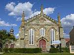 ELONGATED, SYMMETRICAL PLAN BELOW RIDGED AND PARAPET GABLED ROOF. THE ENTRANCE IS SITUATED IN THE GABLE WHICH IS ORNATELY DETAILED WITH BUTRESSES, LARGE POINTED ARCH WINDOWS AND A VENTILATOR. THE TIMBER ENTRANCE DOOR IS ALSO POINTED ARCHED AND HAS A RAI This historic Methodist Church at King William's Town was built in 1855 in the neo-Gothic style. It was later used by the local German Baptist Congregation and is now the home of the South African Missionary Museum.
Type of site: Church, Museum
Current use: Mission Church. |
| 9/2/050/0028 | Old Methodist Manse, 25 Berkley Street, King William's Town | DOUBLE STOREY, ELONGATED PLAN BELOW A RIDGED AND PARAPET GABLED ROOF. THE VERANDAH ON THE FRONT OF THE HOUSE IS CONCAVELY ROOFED AND SUPPORTED BY TIMBER COLUMNS WITH CAPITALS AND BALUSTRADES. FENNESTRATION MAKES USE OF 18 PANE SASH WINDOWS. The old Methodist manse was built in approximately 1855. It is a simple, double-storeyed building with a corrugated iron roof and a wooden balcony which stretches from one side of the front facade to the other.
Type of site: Parsonage. Current use: Private home. |
King William's Town | King William's Town | Provincial Heritage Site | 32°52′25″S 27°23′17″E | |
| 9/2/050/0029 | Old Synagogue, Berkley Street, King William's Town | ELONGATED PLAN BELOW RIDGED AND PARAPET GABLED ROOF WITH A CENTRAL ENTRANCE IN THE GABLE. THE GALE IS SEMI-CIRCULAR IN FORM AND DECORATED WITH ORNATE PLASTER MOULDINGS. FENESTRATION MAKES USE OF 4 PANE CASEMENT WINDOWS WITH TRIANGULAR FANLIGHTS. This predominantly neo-Gothic building probably dates from the eighteen-fifties and was used for several decades as a school by the Wesleyans. The building has been used as a synagogue since 1908.
Type of site: Synagogue. Current use: Synagogue. |
King William's Town | King William's Town | Provincial Heritage Site | 32°52′27″S 27°23′14″E | |
| 9/2/050/0036 | Lutheran Church complex, Braunschweig | This Lutheran Church complex consisting of the neo-Gothic church building of 1904, the parsonage of 1860 and the school building of 1860 and extension of 1904, is closely associated with the arrival of the German Legion in 1857.
Type of site: Church Complex. |
King William's Town | King William's Town | Provincial Heritage Site | 32°47′10″S 27°22′12″E | |
| 9/2/050/0038 | Steve Biko's House, 698 Ngxata Street, Ginsberg, King William's Town | . | King William's Town, Ginsberg | King William's Town | Provincial Heritage Site | 32°53′41″S 27°23′12″E |  . |
| 9/2/050/0041 | Upper Needs Camp, King William's Town District Cuylerville | Upper and Lower Need’s Camp are two lime quarries beside the main road from King William’s Town to East London.
Upper Need’s Camp lies on a hill just within the Divisional boundary of King William’s Town. On the site there are geological deposits containing fossils dating back to the Cretaceous Period. It is the intention to preserve the deposits for future geological research. |
King William's Town | Provincial Heritage Site | 33°00′45″S 27°37′05″E | | |
| 9/2/051/0003 | The Look Out, Kirkwood District | A portion of land with a raised brick platform, and an enclosed area with a few graves. The national road runs almost due north from Port Elizabeth, and where it veers north eastwards to Grahamstown a gravel road continues in a northerly direction to the Addo Elephant National Park. Located some 65km from Port Elizabeth on the R336 traveling towards Kirkwood turning off at Sunlands and proceeding for ± 3-5km. The Lookout is a raised brick platform erected by Sir Percy Fitzpatrick (the well-known author of Jock in the Bushveld) in order to get a better view of the countryside below the hill. | Uitenhage | Kirkwood | Provincial Heritage Site | 33°25′45″S 25°26′10″E | |
| 9/2/053/0003 | St Paul's Church, Komga | The original part of this church was completed in 1866 and was used as a temporary fort during the Ninth Frontier War (1877-78). The chancel was added in 1880 and the castellated tower early in the 20th century.
Type of site: Church. |
Komga | Komga | Provincial Heritage Site | 32°41′35″S 28°00′29″E | |
| 9/2/053/0004 | Komga Public Library, 12 St Johns Street, Komga | This library building with its neo-Gothic features is one of the oldest buildings in the town and was erected in 1892 to meet the needs of the inhabitants of the village that grew around the military base, which was established here in 1877.
Type of site: Library. |
Komga | Komga | Provincial Heritage Site | 32°42′21″S 28°00′08″E | |
| 9/2/057/0004 | Dutch Reformed Church, Joubert Street, Lady Grey | Type of site: Church
Current use: Church : Dutch Reformed. |
Lady Grey | Lady Grey | Provincial Heritage Site | 30°42′38″S 27°13′09″E | 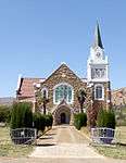 Type of site: Church
Current use: Church : Dutch Reformed. |
| 9/2/059/0002-004 | M.O.T.H. Building, Maclear | . | Maclear | Maclear | Register | 31°04′02″S 28°20′43″E | |
| 9/2/059/0003 | Dinosaur Track Site, Oakleigh, Maclear District | Current use: Palaeontological site. | Maclear | Maclear | Provincial Heritage Site | 30°58′11″S 28°15′54″E | |
| 9/2/061/0004 | Karel Theron Primary School, Victoria Street, Middelburg | Type of site: School. | Middelburg | Middelburg | Provincial Heritage Site | 31°29′30″S 25°00′20″E | |
| 9/2/061/0005 | Reformed Church, Meintjies Street, Middelburg | This neo-Gothic church building was erected in the years 1861 to 1862, soon after the Reformed Church was established in 1859. It is the oldest Reformed church building in the Cape Province.
Type of site: Church. |
Middelburg | Middelburg | Provincial Heritage Site | 31°29′46″S 25°00′21″E | 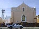 This neo-Gothic church building was erected in the years 1861 to 1862, soon after the Reformed Church was established in 1859. It is the oldest Reformed church building in the Cape Province.
Type of site: Church. |
| 9/2/061/0006/001 | P W Vorster Museum, Grootfontein Agricultural College, Middelburg District | Type of site: Museum
Current use: Museum. |
Middelburg | Middelburg | Provincial Heritage Site | 31°28′18″S 25°01′40″E | |
| 9/2/061/0006/002 | Old Officers' Mess, Grootfontein Agricultural College, Middelburg District | Type of site: Mess. | Middelburg | Middelburg | Provincial Heritage Site | 31°28′18″S 25°01′40″E | |
| 9/2/061/0008 | Haystead and Ford, 7 Market Street, Middelburg | . | Middelburg | Middelburg | Provincial Heritage Site | 31°29′44″S 25°00′24″E | |
| 9/2/062/0003 | Magistrate's Court, Smith Street, Molteno | Type of site: Courthouse. | Molteno | Molteno | Provincial Heritage Site | 31°23′50″S 26°21′47″E | 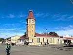 Type of site: Courthouse. |
| 9/2/070/0003 | Old Residency, Rawson Street, Pearston | Type of site: Residency. | Pearston | Pearston | Provincial Heritage Site | 32°35′00″S 25°08′10″E | |
| 9/2/070/0004 | Carl E Froelich's Shop, 58 Voortrekker Street, Pearston | . | Pearston | Pearston | Provincial Heritage Site | 32°35′00″S 25°08′30″E | |
| 9/2/077/0003 | Hexagon, Queenstown | The Hexagon was originally laid out in the center of Queenstown for defence purposes, and has remained the focal point of the town plan. The idea of this hexagon shape originated with Commander T. H. Bowker. | Queenstown | Queenstown | Provincial Heritage Site | 31°53′46″S 26°52′16″E | |
| 9/2/077/0004 | Old Municipal Market, 5 Hexagon, Queenstown | Type of site: Market. | Queenstown | Queenstown | Provincial Heritage Site | 31°53′46″S 26°52′14″E | |
| 9/2/077/0005 | Town Hall, Cathcart Road, Queenstown | This sandstone building was designed by the architect Sidney Stent and erected by the builders Male and Kirton. The cornerstone was laid on 24 May 1882 by the wife of Mayor D. S. Barrable.
Type of site: Town Hall. |
Queenstown | Queenstown | Provincial Heritage Site | 31°53′52″S 26°52′26″E | 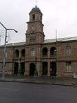 This sandstone building was designed by the architect Sidney Stent and erected by the builders Male and Kirton. The cornerstone was laid on 24 May 1882 by the wife of Mayor D. S. Barrable.
Type of site: Town Hall. |
| 9/2/077/0008 | Museum, Naude Street, Queenstown | This building was originally erected in 1868 as a primary school. It is an outstanding example of a Victorian school building and is closely associated with the history of Queenstown.
Current use: Museum. |
Queenstown | Queenstown | Provincial Heritage Site | 31°53′42″S 26°52′20″E | |
| 9/2/077/0009 | Queen's College, Berry Street, Queenstown | The original portion of the Queen's College building complex was designed in 1897 and the cornerstone of the main entrance building was laid on 15 September 1897. The school was extended in 1914 and again in 1919 and 1920. Cross bridge, continue up Peacock Road and then turn left into Berry Street. | Queenstown | Queenstown | Provincial Heritage Site | 31°53′25″S 26°52′35″E | .jpg) The original portion of the Queen's College building complex was designed in 1897 and the cornerstone of the main entrance building was laid on 15 September 1897. The school was extended in 1914 and again in 1919 and 1920. Cross bridge, continue up Peacock Road and then turn left into Berry Street. |
| 9/2/082/0003 | Old Hope Congregational Church and Parsonage, Paulet Street, Somerset East | The property on which the church complex is situated was bequeathed to the London Missionary Society in 1842 by Mrs Dorothy Edwards, widow of the Rev. John Evans of Cradock. The parsonage, which was built in the Victorian style, dates from the period 1825
Type of site: Church and Parsonage. |
Somerset East | Somerset East | Provincial Heritage Site | 32°42′53″S 25°35′08″E | 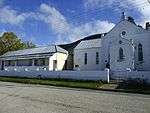 The property on which the church complex is situated was bequeathed to the London Missionary Society in 1842 by Mrs Dorothy Edwards, widow of the Rev. John Evans of Cradock. The parsonage, which was built in the Victorian style, dates from the period 1825
Type of site: Church and Parsonage. |
| 9/2/082/0003-001 | Old Hope Congregational Church, Paulet Street, Somerset East | The property on which this church complex is situated was bequeathed to the London Missionary Society in 1842 by Mrs Dorothy Edwards, widow of the Rev. John Evans of Cradock. The parsonage, which was built in the Victorian style, dates from the period 1825.
Type of site: Church. |
Somerset East | Somerset East | Provincial Heritage Site | 32°42′53″S 25°35′08″E | 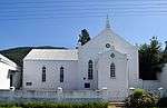 The property on which this church complex is situated was bequeathed to the London Missionary Society in 1842 by Mrs Dorothy Edwards, widow of the Rev. John Evans of Cradock. The parsonage, which was built in the Victorian style, dates from the period 1825.
Type of site: Church. |
| 9/2/082/0003-002 | Old Congregational Church Parsonage, 64 Paulet Street, Somerset East | The property on which the church complex is situated was bequeathed to the London Missionary Society in 1842 by Mrs Dorothy Edwards, widow of the Rev. John Evans of Cradock. The parsonage, which was built in the Victorian style, dates from the period 1825.
Type of site: Parsonage. |
Somerset East | Somerset East | Provincial Heritage Site | 32°42′53″S 25°35′08″E |  The property on which the church complex is situated was bequeathed to the London Missionary Society in 1842 by Mrs Dorothy Edwards, widow of the Rev. John Evans of Cradock. The parsonage, which was built in the Victorian style, dates from the period 1825.
Type of site: Parsonage. |
| 9/2/082/0004 | Ann's Villa, Somerset East District | . | Somerset East | Somerset East | Provisional Protection | 33°15′14″S 25°46′22″E | 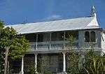 . |
| 9/2/082/0005 | Somerset East Museum, Somerset East | This double-storeyed Georgian building was erected about 1820 as the headquarters of the Somerset Experimental Farm. From 1825 to 1829 it was used as the Drostdy, after which it was transferred to the Wesleyan Church.
Type of site: House. Current use: Museum. |
Somerset East | Somerset East | Provincial Heritage Site | 32°43′15″S 25°34′23″E | 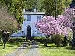 This double-storeyed Georgian building was erected about 1820 as the headquarters of the Somerset Experimental Farm. From 1825 to 1829 it was used as the Drostdy, after which it was transferred to the Wesleyan Church.
Type of site: House.
Current use: Museum. |
| 9/2/082/0006 | Dutch Reformed Church, Charles Street, Somerset East | The enlargement of this church, the original portions of which date from the Eighteen-thirties, was planned by Carl Otto Hager. He also supervised the building activities for 18 months. The rebuilt church is predominantly neo-Gothic in style.
Architectural style: altered by Hager. Type of site: Church. Current use: Church. |
Somerset East | Somerset East | Provincial Heritage Site | 32°43′10″S 25°35′09″E | 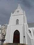 The enlargement of this church, the original portions of which date from the Eighteen-thirties, was planned by Carl Otto Hager. He also supervised the building activities for 18 months. The rebuilt church is predominantly neo-Gothic in style.
Architectural style: altered by Hager.
Type of site: Church.
Current use: Church. |
| 9/2/082/0007 | Walter Battiss Art Museum, 45 Paulet Street, Somerset East | Double-storey rectangular plan with single-storey lean-to to 3/4 of rear. Pitched corrugated iron roof. Moulded surrounds to openings. Quoining to edges. Octagonal chimneys. Sets of two to ends and 4 to centre. Front door 6 (flush) panel. This Georgian double-storeyed building was originally erected in about 1815 by Lord Charles Somerset for officers and presumably also soldiers who were stationed on the Eastern Frontier. The Victorian veranda was added later.
Type of site: House Previous use: Officers' Mess, Residence, Hotel. Current use: Art Museum. |
Somerset East | Somerset East | Provincial Heritage Site | 32°42′55″S 25°35′13″E |  Double-storey rectangular plan with single-storey lean-to to 3/4 of rear. Pitched corrugated iron roof. Moulded surrounds to openings. Quoining to edges. Octagonal chimneys. Sets of two to ends and 4 to centre. Front door 6 (flush) panel. This Georgian double-storeyed building was originally erected in about 1815 by Lord Charles Somerset for officers and presumably also soldiers who were stationed on the Eastern Frontier. The Victorian veranda was added later.
Type of site: House Previous use: Officers' Mess, Residence, Hotel.
Current use: Art Museum. |
| 9/2/082/0008 | 154 Nojoli Street, Somerset East | This property, which was granted to J. van Dyk on 1 September 1825, was one of the first lots to be allocated immediately after the founding of Somerset East on the old experimental farm of Lord Charles Somerset in 1825. | Somerset East | Somerset East | Provincial Heritage Site | 32°43′10″S 25°34′47″E | 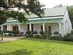 This property, which was granted to J. van Dyk on 1 September 1825, was one of the first lots to be allocated immediately after the founding of Somerset East on the old experimental farm of Lord Charles Somerset in 1825. |
| 9/2/082/0009 | 60 Paulet Street, Somerset East | These three properties, granted to Jan Jonathan Durandt, William MacDonald Mackay and Robert Robinson, respectively, were three of the first lots to be allocated immediately after the founding of Somerset East on the old experimental farm of Lord Charles. | Somerset East | Somerset East | Provincial Heritage Site | 32°42′52″S 25°35′12″E | 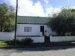 These three properties, granted to Jan Jonathan Durandt, William MacDonald Mackay and Robert Robinson, respectively, were three of the first lots to be allocated immediately after the founding of Somerset East on the old experimental farm of Lord Charles. |
| 9/2/082/0010 | 62 Paulet Street, Somerset East | These three properties, granted to Jan Jonathan Durandt, William MacDonald Mackay and Robert Robinson, respectively, were three of the first lots to be allocated immediately after the founding of Somerset East on the old experimental farm of Lord Charles. | Somerset East | Somerset East | Provincial Heritage Site | 32°42′52″S 25°35′10″E | 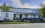 These three properties, granted to Jan Jonathan Durandt, William MacDonald Mackay and Robert Robinson, respectively, were three of the first lots to be allocated immediately after the founding of Somerset East on the old experimental farm of Lord Charles. |
| 9/2/082/0011 | 49 Paulet Street, Somerset East | These three properties, granted to Jan Jonathan Durandt, William MacDonald Mackay and Robert Robinson, respectively, were three of the first lots to be allocated immediately after the founding of Somerset East on the old experimental farm of Lord Charles. | Somerset East | Somerset East | Provincial Heritage Site | 32°42′55″S 25°35′10″E | 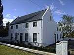 These three properties, granted to Jan Jonathan Durandt, William MacDonald Mackay and Robert Robinson, respectively, were three of the first lots to be allocated immediately after the founding of Somerset East on the old experimental farm of Lord Charles. |
| 9/2/082/0012 | 107 Paulet Street, Somerset East | The core of this dwelling-house, which is predominantly in the Georgian style, presumably formed part of the original homestead of the old experimental farm of Lord Charles Somerset that was subdivided in 1825 and that formed the basis of the present Somerset East.
Type of site: House. Current use: Dwelling. |
Somerset East | Somerset East | Provincial Heritage Site | 32°42′52″S 25°35′22″E | 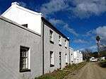 The core of this dwelling-house, which is predominantly in the Georgian style, presumably formed part of the original homestead of the old experimental farm of Lord Charles Somerset that was subdivided in 1825 and that formed the basis of the present Somerset East.
Type of site: House.
Current use: Dwelling. |
| 9/2/082/0013-001 | Old College Building, New Street, Somerset East | . | Somerset East | Somerset East | Provincial Heritage Site | 32°43′19″S 25°34′44″E | 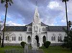 . |
| 9/2/082/0013-002 | College House, Gill College, Somerset East | Somerset East | Somerset East | Provincial Heritage Site | 32°43′19″S 25°35′17″E | 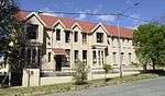 | |
| 9/2/082/0014 | Old Bellevue Seminary, 72 Paulet Street, Somerset East | Type of site: Seminary. | Somerset East | Somerset East | Provincial Heritage Site | 32°42′52″S 25°35′22″E | 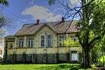 Type of site: Seminary. |
| 9/2/086/0003 | Bulhoek, Steynsburg District | The farm Bulhoek is situated about 20 km north of Steynsburg, at the foot of the Suurberg, on the road to Venterstad. This farm has acquired a certain degree of fame as the traditional birthplace of the illustrious President Paul Kruger.
This pioneer house is one of the best existing examples of a typical trekboer house and dates from 1817. Elsie Steyn, President Kruger's mother grew up on this farm. Type of site: House. |
Steynsburg | Steynsburg | Provincial Heritage Site | 31°16′43″S 25°40′36″E | |
| 9/2/087/0003 | Dutch Reformed Church, Sarel Cilliers Street, Steytlerville | Type of site: Church. | Steytlerville | Steytlerville | Provincial Heritage Site | 33°19′52″S 24°20′39″E | 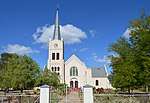 Type of site: Church. |
| 9/2/087/0004 | 22 Victoria Road, Steytlerville | A somewhat unusual variation of a Karroo cottage, in that it does not have a flat roof. The building is in excellent condition. | Steytlerville | Steytlerville | Register | 33°19′58″S 24°19′58″E | |
| 9/2/090/0005 | Bethel Mission Church, Stutterheim | It was founded by Pastor J. L. Dohne of the Berlin Missionary Society on 2 January 1837, and is the oldest mission station of that Society in the whole of the Eastern Province. Dohne was one of six Berlin missionaries who arrived at the Cape in 1836.
Type of site: Church. |
Stutterheim | Stutterheim | Provincial Heritage Site | 32°33′42″S 27°26′02″E |  It was founded by Pastor J. L. Dohne of the Berlin Missionary Society on 2 January 1837, and is the oldest mission station of that Society in the whole of the Eastern Province. Dohne was one of six Berlin missionaries who arrived at the Cape in 1836.
Type of site: Church. |
| 9/2/090/0006 | Ganger's Cottage No 17, East London and Queenstown Railway, Stutterheim District | This fortified house is one of the few remaining examples of a series of similar structures which were built during the Frontier War of 1877-1878 to protect the railway line between East London and Toise River. | Stutterheim | Stutterheim | Provincial Heritage Site | 32°33′47″S 27°26′06″E | 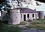 This fortified house is one of the few remaining examples of a series of similar structures which were built during the Frontier War of 1877-1878 to protect the railway line between East London and Toise River. |
| 9/2/090/0007 | Baron von Stutterheim Mill, Stutterheim | This double-storeyed stone building, known as the Baron von Stutterheim Mill, was erected by Mr H. J. Adkins, official contractor of the British-German Legion military settlers, during the years 1860 to 1861 on the instruction of Baron Richard von Stutterheim.
Type of site: Mill. |
Stutterheim | Stutterheim | Provincial Heritage Site | 32°34′03″S 27°24′58″E | |
| 9/2/090/0010 | Mgwali Mission complex, Stutterheim District | Type of site: Mission Station
Current use: Church. |
Mgwali | Stutterheim | Provincial Heritage Site | 32°40′41″S 27°43′51″E | |
| 9/2/090/0010-002 | Manse, Mgwali Mission complex, Stutterheim District | Type of site: Parsonage
Current use: Minister's residence. |
Mgwali | Stutterheim | Provincial Heritage Site | 32°41′07″S 27°42′29″E | |
| 9/2/090/0010-003 | Original school, Mgwali Mission complex, Stutterheim District | Type of site: School
Current use: Vacant. |
Mgwali | Stutterheim | Provisional Protection | 32°42′40″S 27°41′48″E | |
| 9/2/090/0010-004 | Old hostel, Mgwali Mission complex, Stutterheim District | Type of site: Hostel
Current use: Vacant. |
Mgwali | Stutterheim | Provisional Protection | 32°41′45″S 27°40′51″E | |
| 9/2/093/0003 | Old Dutch Reformed Church Parsonage, 17 Grey Street, Tarkastad | This parsonage was built soon after the arrival of the Reverend J. G. S. de Villiers as the first Minister of Tarkastad in 1864. This double-storeyed building has a unique wrought-iron verandah.
Type of site: Pastorie. |
Tarkastad | Tarkastad | Provincial Heritage Site | 32°00′30″S 26°15′59″E | |
| 9/2/095/0002-304 | Park Centre, 17 Upper Church Street, Uitenhage | Current use: Community.
The Park Centre, formally Riebeeck College are amongst the oldest school buildings in Uitenhage and make up an important streetscape along a major thoroughfare in the town. |
Uitenhage | Uitenhage | Register | 33°45′53″S 25°24′04″E | |
| 9/2/095/0004 | Dutch Reformed Church Hall, 112 Caledon Street, Uitenhage | This fine building was designed in 1818 but completed only in 1843 and was the Dutch Reformed Church until it became a church hall in 1927.
The establishment of a new magistracy was usually followed immediately by the establishment of a congregation. Type of site: Church Hall. |
Uitenhage | Uitenhage | Provincial Heritage Site | 33°45′59″S 25°23′59″E | |
| 9/2/095/0005 | Muir College Boys' Primary School, Park Avenue, Uitenhage | Type of site: School
Current use: Educational/School. |
Uitenhage | Uitenhage | Provincial Heritage Site | 33°45′46″S 25°23′58″E | |
| 9/2/095/0006 | Old Magistrate's Court, Caledon Street, Uitenhage | Type of site: Courthouse. | Uitenhage | Uitenhage | Provincial Heritage Site | 33°45′59″S 25°23′59″E | |
| 9/2/095/0007 | Scheepers House, 11/13 Cuyler Street, Uitenhage | . | Uitenhage | Uitenhage | Provincial Heritage Site | 33°45′51″S 25°23′38″E | |
| 9/2/095/0008 | 34 Cuyler Street, Uitenhage | . | Uitenhage | Uitenhage | Provincial Heritage Site | 33°45′55″S 25°23′33″E | |
| 9/2/095/0010 | Site of Anglo-Boer War Concentration Camp, Uitenhage | The concentration camp site at Uitenhage was in use from April to October 1902, and was one of the last of about 50 concentration camps that were established during the Anglo-Boer War. Mainly women and children from the Orange Free State were housed here.
Type of site: Concentration Camp. |
Uitenhage | Uitenhage | Provincial Heritage Site | 33°43′35″S 25°25′23″E | |
| 9/2/095/0011 | Old Drostdy, 50 Caledon Street, Uitenhage | The designer of the Drostdy building was M L Thibault, the well-known architect. Construction started in 1804, was completed in 1810. Today the Drostdy forms part of the historic core of Uitenhage.
Type of site: Drostdy. |
Uitenhage | Uitenhage | Provincial Heritage Site | 33°46′10″S 25°24′15″E | 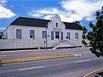 The designer of the Drostdy building was M L Thibault, the well-known architect. Construction started in 1804, was completed in 1810. Today the Drostdy forms part of the historic core of Uitenhage.
Type of site: Drostdy. |
| 9/2/095/0012 | Town Hall, 25 Market Street, Uitenhage | Type of site: Town Hall. | Uitenhage | Uitenhage | Provincial Heritage Site | 33°46′08″S 25°24′00″E | 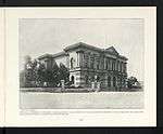 Type of site: Town Hall. |
| 9/2/095/0013 | Old Railway Station, Market Street, Uitenhage | This railway station, which was erected during 1875, is the original terminus building of one of the earliest railway lines in South Africa.
Type of site: Railway Station. |
Uitenhage | Uitenhage | Provincial Heritage Site | 33°46′13″S 25°23′56″E | 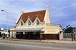 This railway station, which was erected during 1875, is the original terminus building of one of the earliest railway lines in South Africa.
Type of site: Railway Station. |
| 9/2/095/0014 | Blenheim House, 4 Baird Street, Uitenhage | Architecturally Blenheim house was vastly altered in the hands of the Dolley family, since it was converted into a double-storeyed house in 1903, with a pair of high gables containing the two dates facing the street. In this respect the house has its Cape Originally built in 1815 as a single-storeyed residence by the Government Surveyor, Mr. Knoble. It was the first house of any size apart from the Drostdy to be built in Uitenhage and was often spoken of as No. 1 Uitenhage. Mr. Knoble was responsible for it. This imposing dwelling-house with its Cape-Dutch features was originally erected in 1815 as a single-storey building. In 1903 an upper storey and a wood-decorated verandah were added. | Uitenhage | Uitenhage | Provincial Heritage Site | 33°46′00″S 25°23′54″E | |
| 9/2/095/0015 | 23 Cuyler Street, Uitenhage | . | Uitenhage | Uitenhage | Provincial Heritage Site | 33°45′52″S 25°23′36″E | |
| 9/2/095/0016 | 21 Cuyler Street, Uitenhage | . | Uitenhage | Uitenhage | Provincial Heritage Site | 33°45′52″S 25°23′36″E | |
| 9/2/095/0017 | Cuyler Manor, Uitenhage District | This predominantly Cape Dutch homestead was erected in 1814 by Colonel Jacob Glen Cuyler, landdrost of Uitenhage. Colonel Cuyler was closely associated with the settlement of the British Settlers of 1820. | Uitenhage | Uitenhage | Provincial Heritage Site | 33°46′10″S 25°24′15″E |  This predominantly Cape Dutch homestead was erected in 1814 by Colonel Jacob Glen Cuyler, landdrost of Uitenhage. Colonel Cuyler was closely associated with the settlement of the British Settlers of 1820. |
| 9/2/095/0024 | Farmstead, Totteridge Park, near Perseverance, Uitenhage District | Type of site: Farm Complex. | Uitenhage | Uitenhage | Provincial Heritage Site | 33°48′24″S 25°31′00″E | |
| 9/2/098/0003 | Reformed Church, 16 Van Wyk Street, Venterstad | Type of site: Church
Current use: Church : Reformed. |
Venterstad | Venterstad | Provincial Heritage Site | 30°46′30″S 25°48′04″E | 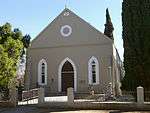 Type of site: Church
Current use: Church : Reformed. |
| 9/2/109/0003 | Dutch Reformed Church, 90 Grey Street, Dordrecht | This rectangular stone church building, with its elegant stone tower of 154 feet, is one of the best examples of the Gothic renewal building style. The cornerstone was laid on 20 May 1882 and the building was officially inaugurated on 18 August 1883.
Type of site: Church. Current use: Church : Dutch Reformed. |
Dordrecht | Wodehouse | Provincial Heritage Site | 31°22′21″S 27°02′54″E | 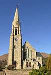 This rectangular stone church building, with its elegant stone tower of 154 feet, is one of the best examples of the Gothic renewal building style. The cornerstone was laid on 20 May 1882 and the building was officially inaugurated on 18 August 1883.
Type of site: Church.
Current use: Church : Dutch Reformed. |
| 9/2/502/0002 | Mission Church, Hertzog, Mpofu District | This church, the cornerstone of which was laid on 4 June 1834, was completed only in the beginning of 1845 owing to the devastation brought about by the Sixth Border War.
Type of site: Church. |
Mpofu | Mpofu | Provincial Heritage Site | 32°34′38″S 26°43′06″E | |
| 9/2/502/0007 | University of Fort Hare Collections, University of Fort Hare, Alice | . | Alice | Alice | Heritage Object | 32°47′00″S 26°53′00″E | |
| 9/2/502/0009 | Fort Armstrong, Balfour, Mpofu District | The town of Balfour on the Kat River stands at the foot of the Katberg Mountain about 40 km due north of Fort Beaufort. Not far to the south-east of the town, the road to Hertzog passes the farm Mesopotamia which nestles in a curve of the Kat River. A tow The fortification that was to protect the settlement here against the Xhosa was called Camp Adelaide. It was converted into a fort in accordance with the overall plan for the defence of the eastern frontier which Sir Benjamin D’Urban introduced after 1835
Type of site: Fort. |
Mpofu | Mpofu | Provincial Heritage Site | 32°33′48″S 26°41′30″E | |
| 9/2/502/0016 | Watch Tower, Peddie | The national road to East London by-passes the village of Peddie on the right; just beyond the village it veers sharply to the left past a plantation of blue-gum trees. The old Watch Tower of Fort Peddie stands hidden amongst these trees.
Type of site: Watch Tower. |
Peddie | Peddie | Provincial Heritage Site | 33°11′11″S 27°07′06″E | |
| 9/2/503/0003 | Jubaeopsis Caffra, Mkambati | This grove of Jubaeopsis caffra, one of the four species of palms indigenous to South Africa, stands at the Mkambati Leprosy Institution in the Lusikisiki district, north of Port St. Johns.
Type of site: Tree. |
Lusikisiki | Lusikisiki | Provincial Heritage Site | 31°16′57″S 29°57′03″E | |
| 9/2/503/0025 | Cretaceous Deposits, Mzamba Beach, Mbizana | The winding road from Port St. Johns to Port Edward, just north of the mouth of the Umtamvnna River, passes through Lusikisiki, Flagstaff and Magusheni. On the coast just south of Port Edward, between the outlets of the Umtamvuna and Mzamba Rivers there is a very important occurrence of fossils of the Upper Creta ceous period.
The deposits at Mzamba Beach were discovered by Captain Garden of the 54th Regiment. The Mzamba Formation provides a condensed record of the period between about 86 and 80 million years ago (Klinger pers.comm.), when there was a beach and shallow sea environment in this area, with large trees, marine reptiles, extinct ammonites and large (up to 1 m) mussels, sea urchins, snails and other shell fossils. Type of site: Fossil Beds. |
Bizana | Mbizana | Provincial Heritage Site | 31°05′50″S 30°10′30″E | |
| CiskeiTemp8 | Domira, Lovedale, Victoria East District | Lovedale, the well-known educational institution is situated at Block Drift on the left bank of the Tyumie River, just north of Fort Hare. Domira is a sturdy, attractive old stone house with a thatched roof in the grounds of the institution. Although Domira was built in 1837, the history of the place actually begins somewhat earlier. The Rev. John Brownlee started missionary work in the Tyumie valley in 1820. Missionaries of the Glasgow Society joined him and a mission station was established. Domira was the residence of Charles Lennox Stretch, diplomatic agent to the Gaikas (1836-1846). It also served as fortress, storm-centre and originally as the headquarters of Sir Andries Stockenstrom during the War of the Axe. | Alice | Victoria East | Provincial Heritage Site | 32°47′00″S 26°53′00″E | |
| Graaff-ReinetTemp | Dutch Reformed Church, Adendorp, Graaff-Reinet District | Type of site: Church. | Adendorp | Graaff-Reinet | Provincial Heritage Site | 32°18′10″S 24°32′53″E | |
| 9/2/033/0007 | Owl House, Erf 306 River Street, Nieu-Bethesda | Karoo type flat-roofed house with a stoep to the front. Outstanding garden features including camel yard. Type of site: Residence Current use: Residential. | Nieu-Bethesda | Graaff-Reinet | Provisional Protection | 31°52′03″S 24°33′09″E |  Karoo type flat-roofed house with a stoep to the front. Outstanding garden features including camel yard. Type of site: Residence Current use: Residential. |
References
| Wikimedia Commons has media related to Cultural heritage monuments in the Eastern Cape. |
Lists of South African Heritage Resources | ||||||||||||||||||||
|---|---|---|---|---|---|---|---|---|---|---|---|---|---|---|---|---|---|---|---|---|
| SAHRA Heritage sites |
| Flag of South Africa | ||||||||||||||||||
| World heritage sites |
| |||||||||||||||||||