List of disputed territories of India
There are several disputed territories of India. A territorial dispute is a disagreement over the possession or control of land between two or more states or over the possession or control of land by a new state and occupying power after it has conquered the land from a former state no longer currently recognized by the new state.

India faces territorial issues with some of its neighbors – China, Pakistan and Nepal.[1] It also has border dispute with Taiwan.[2] India has resolved its un-demarcated border with Bhutan, which included multiple irregularities. India also resolved its border disputes with Bangladesh and Sri Lanka.
Current disputes
Taiwan (Republic of China)
_Territorial_Claims.jpg)
Throughout the Cold War, the government of Taiwan had the same understanding on the China-India border dispute as the People's Republic of China (PRC).[2] In 1962, Taiwan's Ministry of Foreign Affairs stated that they did not recognise the legality of McMahon Line. The same year western countries increased pressure on the then Taiwan leader, Chiang Kai-shek, to recognise the legality of McMahon Line in order to isolate Beijing.[2] However, Chiang dismissed McMahon Line as 'imperialist imposition on China'. In February 1987, India's move to elevate the status of 'Arunachal centrally administered region' to the state of Arunachal Pradesh was declared null and void by Taiwan's Ministry of Foreign Affairs.[2] The Ministry, in a formal statement, stated that it did not recognise 'illegal occupation' of ROC territory south of McMahon Line and the establishment of 'Arunachal Pradesh state' was an illegal act. In 1995, Ambassador Pei-yin Teng (Taiwan's first representative to India) in response to Indian member of the parliament, stated that Taiwan did not recognise McMahon Line.[2] However, Pei-yin Teng was the last Taiwanese official who made a statement against the McMahon Line. Since, then Taiwan has not made any statement on China-India dispute and has adopted a neutral stance on the dispute.[2]
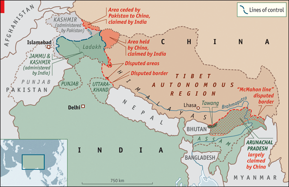
People's Republic of China
The Depsang Plains are located on the border of the Indian union territory of Ladakh and the disputed zone of Aksai Chin. The Chinese Army occupied most of the plains during its 1962 war with India,[3] while India controls the western portion of the plains.[4] The dispute remains unresolved.[5]
Arunachal Pradesh is a state of India created on 20 January 1972, located in the far northeast. It borders the states of Assam and Nagaland to the south, and shares international borders with Burma in the east, Bhutan in the west, and the China in the north. The majority of the territory is claimed by China as part of South Tibet. The northern border of Arunachal Pradesh reflects the McMahon Line, a 1914 treaty between the United Kingdom and the Tibetan government which was never accepted by the Chinese government, was also considered invalid by Tibetans due to unmet condition specified in the treaty,[6] and not broadly enforced by the Indian government until 1950. This territory is administered by India.[7][8]
Pakistan
Kashmir is a disputed region between Pakistan and India.
Nepal
Major areas of dispute between India and Nepal are Kalapani, Limpiyadhura, Lipulekh, Susta, Mechi, and Tanakpur.[9] An estimated 60,000 hectares of border land is currently disputed between India and Nepal.[10]
Although claimed by Nepal, Kalapani has been administered by Indian army since the 1962 border war with China.[9] The 1816 Treaty of Sugauli signed by Kingdom of Nepal and British India in 1816 utilizes the Kali River as Nepal's western boundary with India. However, lack of consensus on what is the precise location of the river Kali has resulted in dispute over whether the land consisting Kalapani, Limpiyadhura and Lipulekh is part of India or Nepal.[11] Some scholars suggest that the lack of consensus is because of British cartographers who kept on shifting the line demarcating the river eastwards for strategic reasons. However, there are also some scholars who believe that lack of consensus is due to the shift in the course of the river over time.[11]
In November 2019, India issued a new political map of India which showed Kalapani as part of India. The new political map of India was rejected by Nepal. Mass protest against India took place across Nepal and outside Indian embassy in Nepal. Protesters accused India of occupying their land.[12] In May 2020, Indian Defence minister, Rajnath Singh inaugurated a 80-km road from Dharchula to Lipulekh pass. Nepal protested against the construction of road in Lipulekh area.[13] Lipulekh area is currently under India's control. However, government of Nepal states that the Lipulekh area belongs to Nepal. On 20 May 2020, Nepal launched its own map showing Kalapani, Limpiyadhura and Lipulekh as parts of its own territory.[14] The new map was subsequently approved by the Nepali parliament on 18 June 2020. India opposed the move, claiming that the decision to include Limpiyadhura, Lipulekh and Kalapani is not based on evidence or historical facts.[15]
On 15 June 2020, Indian border police, Sashastra Seema Bal (SSB) reported that border pillars which served as demarcation, were missing along the India-Nepal border. SSB also reported that Nepali border police has established five new border outpost near the disputed area.[16] On 19 June, Nepal started deploying its troops near the Kalapani and other disputed areas. The troops had established camps and they were working on building a helipad in the area.[17] In the same month Nepali Army Chief, General Purna Chandra Thapa, after visiting Kalapani border area, stated that Nepali army will start building army barracks and border outposts near the Kalapani area.[18] On 21 June, Indian media reported that radio stations in Nepal were conducting a propaganda campaign against India by playing anti-India songs.[19]
Susta is another territory which is disputed between Nepal and India. It currently controlled by India and is a part of Bihar province. Residents of a village in Susta state that Susta belongs to Nepal and they are Nepali citizens.[20] The 1816 Treaty of Sugauli defined Gandaki river as the international boundary between India and Nepal. The right bank of Gandaki river was under Nepal’s control while the left bank was under India's control. Susta village was initially on the right bank when the treaty was signed and it was a part of Nepal. However, over the years, the Gandaki river changed its course and Susta moved to the left bank and is now currently under India's control.[20] Government of Nepal has repeatedly stated that Susta belongs to Nepal and Indian government should return the area.
Former disputes
However, the Indian government has stated that "No territory belonging to India was ceded nor sovereignty relinquished since the area was in dispute and had never been demarcated" and that the dispute on the status of the island was settled in 1974 by an agreement, and both countries took into account historical evidence and legal aspects.[21]
South Talpatti (as it was known internationally) or Bangabandhu Island (as it was known in Bangladesh) or New Moore Island (as it was known in India) was a small uninhabited offshore sandbar landform in the Bay of Bengal, off the coast of the Ganga-Brahmaputra Delta region. It emerged in the Bay of Bengal on the Bangladesh side of river that makes the boundary between India and Bangladesh in the aftermath of the Bhola cyclone in 1970, and disappeared before or during Cyclone Aila in 2009. In March 2010, Sugata Hazra of the School of Oceanographic Studies at Jadavpur University, Kolkata, India, said that the island had disappeared and that sea level rise caused by climate change was a factor.[22]
The enclaves were reputedly part of a high stake card or chess games centuries ago between two regional kings, the Maharaja of Cooch Behar and the Nawab of Rangpur and the result of a confused outcome of a treaty between the Kingdom of Koch Bihar and the Mughal Empire. After the partition of India in 1947, Cooch Behar district was merged with India and Rangpur went to then East Pakistan, which became Bangladesh in 1971. The prime ministers of India and Bangladesh signed a Land Boundary Agreement in 1974 to exchange enclaves and simplify the international border. In 1974 Bangladesh approved a proposed treaty, Land Boundary Agreement, to exchange all enclaves within each other's territories, but India did not ratify it. Another agreement was agreed upon in 2011 to exchange enclaves and adverse possessions. A revised version of the agreement was finally adopted by the two countries 41 years later, when the Parliament of India passed the 100th Amendment Act to the Indian Constitution on May 7, 2015.[23] Inside the main part of Bangladesh, there were 111 Indian enclaves (17,160.63 acres), while inside the main part of India, there were 51 Bangladeshi enclaves (7,110.02 acres). In respect of adverse possessions, India received 2,777.038 acres of land and transferred 2267.682 acres to Bangladesh. India ratified the agreement by constitutional amendment in May 2015.[24] Under this agreement, the enclave residents could continue to reside at their present location or move to the country of their choice.[25] [26] The adverse possession of Boraibari went to Bangladesh.[27] The unmarked borders between the nations were also finally solved regarding Daikhata-Dumabari, Muhurichar river island[28] and Pyrdiwah.[29]
See also
External links
References
- Vaid, Darvi (10 May 2020). "New road rouses territorial dispute between India and Nepal". DW.com.
- P. Panda, Jagannath (8 April 2019). India and China in Asia: Between Equilibrium and Equations. Routledge.
- Manoj Joshi (2013-05-07). "Making sense of the Depsang incursion". The Hindu. Retrieved 2014-03-15.
- "Khurshid to visit China on May 9, no date for flag meet". Hindustan Times. 2013-04-25. Retrieved 2014-03-15.
- "Let's shake hands: 20 days on, China withdraws troops from Ladakh : India, News - India Today". Indiatoday.intoday.in. 2013-05-05. Retrieved 2014-03-15.
- Tsering Shakya (1999). The Dragon in the Land of Snows: A History of Modern Tibet Since 1947. Columbia University Press. pp. 279–. ISBN 978-0-231-11814-9.
- Guo, Rongxing (2006). Territorial Disputes and Resource Management: A Global Handbook. Nova Publishers. p. 51. ISBN 9781600214455.
- Shurtleff, William; Aoyagi, Akiko (2010). History of Soybeans and Soyfoods in South Asia / Indian Subcontinent (1656-2010): Extensively Annotated Bibliography and Sourcebook (illustrated ed.). Soyinfo Center. p. 952. ISBN 9781928914310.
- "India and Nepal's Slow-Motion Border Dispute". The Diplomat. 4 January 2020.
- "As a river changed its course, a village on the India-Nepal border became disputed territory". Scroll.in. 19 March 2017.
- "Mapping the history of Kalapani dispute between India and Nepal". Indian Express. 13 June 2020.
- "India's updated political map stirs controversy in Nepal". 8 November 2019. Text "Al Jazeera" ignored (help)
- "Nepal summons Indian envoy to protest opening of road to Lipulekh". Hindustan Times. 11 May 2020.
- Bhattacherjee, Kallol (20 May 2020). "Nepal's new political map claims India's territories" – via www.thehindu.com.
- "Nepal Parliament approves new map that includes land India claims". Al Jazeera. 18 June 2020.
- "India-Nepal border posts missing: SSB". Times of India. 15 June 2020.
- "In a first, Nepal deploys its troops at border with India". India Today. 19 June 2020.
- "Nepal to set up army barrack, border outpost near Kalapani after getting controversial new map". theprint.in. 19 June 2020.
- "Nepal stations bombard Uttarakhand villages with anti-India". Times of India. 21 June 2020.
- "As a river changed its course, a village on the India-Nepal border became disputed territory". scroll.in. 19 March 2017.
- Special Correspondent (2014-02-08). "Kachatheevu was not ceded to Sri Lanka & can't be retrieved – Government Of India". The Hindu. Retrieved 2014-02-18.
- Wade, Matt (March 25, 2010). "Rising sea level settles border dispute". The Sydney Morning Herald. Retrieved April 4, 2010.
- "The Constitution (119th Amendment) Bill, 2013" PRS India. Accessed 10 May 2015.
- India (2 December 2014). "Everything you need to know: Land swap in offing with Bangladesh to end disputes". The Indian Express. Retrieved 29 May 2015.
- Sougata Mukhopadhyay (7 September 2011). "India-Bangladesh sign pact on border demarcation". CNN-IBN. Retrieved 2011-09-20.
- Special Correspondent (2015-05-07). "Parliament passes historic land accord bill to redraw border with Bangladesh". The Times Of India. Retrieved 2015-05-07.
- MANOJ ANAND (2015-05-08). "Bangladesh land swap deal: AGP calls bandh, says PM Modi betrayed people". The Asian Age. Retrieved 2015-05-08.
- Shubhajit Roy (2014-12-02). "Everything you need to know: Land swap in offing with Bangladesh to end disputes". Indian Express. Retrieved 2014-12-02.
- Special correspondent (2015-05-06). "Meghalaya groups flay land-swap deal". Calcutta Telegraph. Retrieved 2014-05-06.