List of crossings of the Schuylkill River
This is a list of bridges and other crossings of the Schuylkill River, from the Delaware River upstream to the source. All locations are in Pennsylvania.
Crossings
| Crossing | Carries | Location | Coordinates | Notes | Images |
|---|---|---|---|---|---|
Philadelphia | |||||
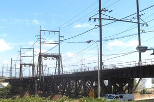
| Girard Point Bridge | Mud Island, Southwest Philadelphia and South Philadelphia | 39°53′32″N 75°11′50″W | Two deck bridge; upper deck southbound |
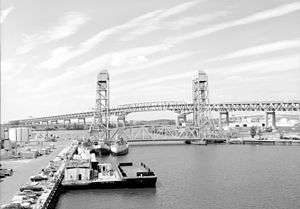 | |
| George C. Platt Bridge | 39°53′53″N 75°12′42″W | Through truss bridge |  | ||
| Passyunk Avenue Bridge | Passyunk Avenue | 39°55′11″N 75°12′07″W | Double-leaf bascule bridge |  | |
| B&O Railroad Bridge | CSX Philadelphia Subdivision | 39°56′08″N 75°12′21″W | Swing bridge |  | |
| Philadelphia, Wilmington and Baltimore Railroad Bridge No. 1 | 39°56′26″N 75°12′18″W | Open swing bridge, abandoned, HAER documentation | 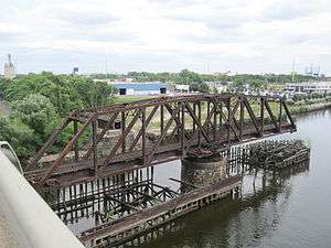 | ||
| Grays Ferry Avenue Bridge | Grays Ferry Avenue | 39°56′28″N 75°12′18″W | 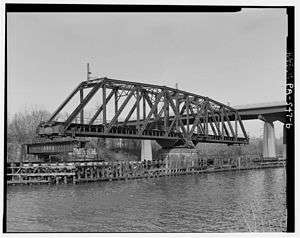 | ||
| University Avenue Bridge | University Avenue | 39°56′34″N 75°11′49″W | Double-leaf bascule bridge |  | |
| Schuylkill Expressway Bridge | 39°56′31″N 75°11′38″W | 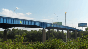 | |||
| Schuylkill Arsenal Railroad Bridge | CSX Harrisburg Subdivision | 39°56′36″N 75°11′30″W | Swing bridge (immobilized) |
| |
| PECO utility tunnel | Electric and steam utility lines | 39°56′37″N 75°11′29″W | |||
| South Street Bridge | South Street | 39°56′49″N 75°11′13″W | Opened November 6, 2010 | 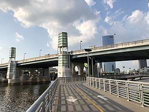 | |
| Walnut Street Bridge | Walnut Street | 39°57′06″N 75°10′54″W |  | ||
| Chestnut Street Bridge | Chestnut Street | 39°57′11″N 75°10′52″W |  | ||
| Market Street Bridge | 39°57′16″N 75°10′49″W | _-_2017.JPG) | |||
| Market–Frankford Line Tunnel | SEPTA Market-Frankford Line | 39°57′16″N 75°10′49″W | Also carries SEPTA Subway-surface lines |  | |
| John F. Kennedy Boulevard Bridge | 39°57′20″N 75°10′48″W | 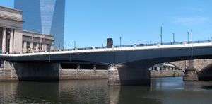 | |||
| SEPTA Regional Rail bridge | SEPTA Regional Rail | 39°57′22″N 75°10′47″W | All lines |  | |
| Vine Street Expressway Bridge | 39°57′36″N 75°10′48″W |  | |||
| Spring Garden Street Bridge | Spring Garden Street | 39°57′51″N 75°11′01″W | Originally the Colossus Bridge |  | |
| West River Drive Bridge | Martin Luther King, Jr. (formerly West River) Drive | 39°57′52″N 75°11′02″W | Passes underneath Spring Garden Street Bridge at center of both bridges |  | |
| Fairmount Water Works Dam | 39°58′02″N 75°11′11″W |  | |||
| Girard Avenue Bridge | 39°58′31″N 75°11′36″W | HABS documentation | 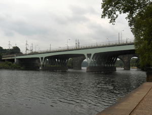 | ||
| Pennsylvania Railroad, Connecting Railway Bridge | SEPTA Trenton Line SEPTA Chestnut Hill West Line Amtrak Northeast Corridor New Jersey Transit Atlantic City Line |
39°58′35″N 75°11′38″W | HAER documentation, HABS documentation | .jpg) | |
| Columbia Railroad Bridge | CSX Trenton Subdivision | 39°59′06″N 75°12′14″W |
| ||
| Strawberry Mansion Bridge | Strawberry Drive | 39°59′43″N 75°11′38″W | HAER documentation, HABS documentation |  | |
| Philadelphia and Reading Railroad, Bridge at West Falls | CSX Trenton Subdivision | 40°00′23″N 75°11′33″W | HAER documentation | .jpg) | |
| Philadelphia and Reading Railroad, Schuylkill River Viaduct, Falls Rail Bridge (stone) | CSX Trenton Subdivision | 40°00′21″N 75°11′32″W | HAER documentation | .jpg) | |
| Twin Bridges | 40°00′24″N 75°11′35″W |  | |||
| Falls Bridge | Calumet Street | 40°00′30″N 75°11′51″W | HAER documentation | .jpg) | |
| City Avenue Bridges | City Avenue | 40°00′42″N 75°12′21″W |  | ||
Montgomery County – Philadelphia | |||||
| Pencoyd Bridge | Rail bridge converted to road bridge | Bala Cynwyd and Manayunk | 40°01′00″N 75°12′48″W | Former PRR industrial spur serving Pencoyd Iron Works and local industries from Schuylkill Branch |  |
| Philadelphia & Reading Railroad Mule Bridge | Norfolk Southern Venice Industrial Track | Bala Cynwyd and Manayunk | 40°01′19″N 75°13′10″W | Former Reading, HAER documentation |  |
| Manayunk Bridge (rail bridge converted to trail bridge) | Cynwyd Heritage Trail (formerly SEPTA Cynwyd Line to Manayunk) | Bala Cynwyd and Manayunk | 40°01′31″N 75°13′35″W | Rail service abandoned 1986 (line truncated at Cynwyd); trail opened 2015 HAER documentation | |
| Green Lane Bridge | West Manayunk and Manayunk | 40°01′34″N 75°13′41″W |  | ||
| Flat Rock Dam | Belmont Hills and Shawmont | 40°02′23″N 75°14′49″W | Mid-1970s concrete replacement of original crib and timber dam |  | |
Montgomery County | |||||
| Fayette Street Bridge (Matsonford Bridge) | West Conshohocken and Conshohocken | 40°04′14″N 75°18′34″W | 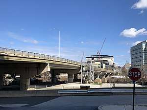 | ||
| Plymouth Dam (removed) | West Conshohocken and Connaughtown | 40°04′30″N 75°18′57″W | Breached; removed 2009 River Map and Water Trail Guide update |
||
| Pearl Harbor Memorial Bridge | West Conshohocken and Connaughtown | 40°04′42″N 75°19′05″W |  | ||
| Upper Merion & Plymouth rail bridge | Swedeland and Ivy Rock | 40°05′26″N 75°19′17″W | Also used as private truck road | ||
| Trenton Cutoff rail bridge | Norfolk Southern Railway Trenton Cutoff | Swedesburg and Black Horse | 40°06′10″N 75°19′30″W | HAER documentation | |
| Schuylkill River Bridge | Swedesburg and Black Horse | 40°06′11″N 75°19′30″W |  | ||
| DeKalb Veterans Memorial Bridge | Bridgeport and Norristown | 40°06′36″N 75°20′40″W | |||
| Bridgeport Bridge | SEPTA Norristown High Speed Line (Route 100) | Bridgeport and Norristown | 40°06′38″N 75°20′47″W | Former Philadelphia and Western Railroad; HAER documentation | |
| Norristown Dam | Bridgeport and Norristown | 40°06′38″N 75°20′49″W | |||
| Rail bridge | Norfolk Southern Morrisville Connecting Track |
Bridgeport and Norristown via Barbadoes Island | 40°06′43″N 75°21′08″W | Crosses under Dannehower Bridge on north side of Barbadoes Island. Former Reading passenger main line to Reading and Pottsville | |
| Dannehower Bridge | Bridgeport and Norristown via Barbadoes Island | 40°06′42″N 75°21′01″W | Twin Span | ||
| Rail bridge | CSX Stony Creek Branch | Barbadoes Island and Norristown | 40°06′28″N 75°21′03″W | Merges into NS Morrisville Connecting Track | |
| Haws Avenue bridge | Barbadoes Island and Norristown | 40°06′55″N 75°21′22″W | Barbadoes Island power plant access | ||
| Schuylkill River Crossing Complex | Port Kennedy and Betzwood | 40°06′27″N 75°25′12″W | Work is under way on a new, five-span structure, 785 feet long with a total width of 146 feet, to carry six lanes of traffic.[1] | 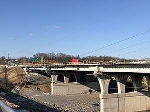 | |
| Sullivan's Bridge ([Old] Betzwood Bridge) |
Former |
Port Kennedy and Betzwood | 40°06′27″N 75°25′14″W | Demolished in 1995,[2] replacement pedestrian and bicycle bridge began construction May 2014[3] and opened August 19, 2016.[4] | 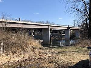 |
Chester County – Montgomery County | |||||
| Pawlings Road bridge | Phoenixville and Audubon | 40°06′53″N 75°28′14″W | |||
| Rail bridge | Valley Forge and Oaks | 40°07′29″N 75°27′41″W | Former Reading Perkiomen Branch, now part of Norfolk Southern Devault Secondary, currently inactive as a branch | ||
| Dam | Island and Oaks | 40°07′44″N 75°28′17″W | |||
| Mont Clare Bridge | Phoenixville and Mont Clare | 40°08′07″N 75°30′31″W | Formerly Gordon's, Starr's, or Jacob's ford |  | |
| Rail bridge | Phoenixville and Mont Clare | 40°08′15″N 75°30′36″W | Former PRR Schuylkill Branch, now Norfolk Southern Devault Secondary, currently out of service | ||
| Black Rock Dam | Phoenixville and Mont Clare | 40°08′53″N 75°30′22″W |  | ||
| Black Rock Bridge | Phoenixville and Mingo | 40°09′32″N 75°30′43″W |  | ||
| Rail bridge | Black Rock Tunnel, Phoenixville and Upper Providence Township | 40°08′53″N 75°31′09″W | Former Reading main line, now Norfolk Southern Harrisburg Line | ||
| Rail bridge | Cromby and Mingo | 40°09′37″N 75°31′37″W | Former Reading (currently Norfolk Southern) industrial spur serving Cromby Power Plant | ||
| Road bridge | East Bridge Street | Spring City and Royersford | 40°10′56″N 75°32′43″W | ||
| Rail bridge (abandoned) | Spring City and Royersford | 40°11′05″N 75°32′48″W | PRR industrial spur connecting Schuylkill Branch with industries in Royersford | ||
| Vincent Dam (breached, removed 2009) | East Vincent Township and Linfield | 40°12′20″N 75°33′53″W | Schuylkill Canal Navigation Dam, removed 2009 | ||
| Rail bridge (removed) | Parker Ford and Linfield | 40°12′13″N 75°34′49″W | PRR industrial spur connecting Schuylkill Branch with industries in Linfield | ||
| Limerick Road bridge | Parker Ford and Linfield | 40°12′18″N 75°34′51″W | |||
| Sanatoga Road Bridge (ruin, removed, approaches macadam) | Fricks Lock and Sanatoga | 40°14′07″N 75°35′46″W | |||
| Rail bridge (abandoned) | Conrail | Fricks Lock and Pottstown | 40°14′00″N 75°36′27″W | Former PRR Schuylkill Branch | |
| Road bridge | Kenilworth and Pottstown | 40°13′54″N 75°37′30″W | |||
| Madison Bridge | Keim Street | Kenilworth and Pottstown | 40°14′05″N 75°38′03″W | Closed October 2010 after a bridge inspection, scheduled for replacement or repair | |
| Hanover Street Bridge | Hanover Street | North Coventry Township and Pottstown | 40°14′32″N 75°39′04″W | ||
| Road bridge | North Coventry Township and Pottstown | 40°14′33″N 75°39′34″W | |||
| Rail Bridge (abandoned) | North Coventry Township and Pottstown | 40°14′39″N 75°39′44″W | Former Reading spur, serviced pig iron works in North Coventry | ||
| Road bridge | North Coventry Township and Stowe | 40°14′35″N 75°40′29″W | |||
Berks County | |||||
| Road bridge | River Road | Unionville (Union Township) and Douglassville | 40°14′59″N 75°43′30″W | ||
| Rail bridge (converted to trail bridge) | Schuylkill River Trail | Unionville (Union Township) and Douglassville | 40°15′22″N 75°43′56″W | ||
| Monocacy Bridge | Main Street | Monocacy (Union Township) and Monocacy Station | 40°15′30″N 75°46′06″W | ||
| Road bridge | Birdsboro and Baumstown | 40°16′06″N 75°48′30″W | Former |
||
| Rail bridge | Norfolk Southern | Birdsboro and Baumstown | 40°16′04″N 75°48′38″W | Reading Belt Branch of Norfolk Southern Harrisburg Line; also former Reading Wilmington & Northern branch | |
| Road bridge | Gibraltar Road | Gibraltar and Lorane | 40°17′20″N 75°52′03″W | ||
| Highway bridge | Ridgewood and Reiffton | 40°18′20″N 75°53′42″W | |||
| Highway bridge | Poplar Neck and Ridgewood | 40°18′31″N 75°54′21″W | |||
| Rail bridge (converted to trail bridge) | Schuylkill River Trail – Thun Trail | Poplar Neck and Ridgewood | 40°18′29″N 75°54′22″W | ||
| Rail bridge | Norfolk Southern | Poplar Neck and Ridgewood | 40°18′12″N 75°54′21″W | Reading Belt branch of Norfolk Southern Harrisburg Line | |
| Road bridge | Poplar Neck Road | Poplar Neck and Ridgewood | 40°18′08″N 75°54′20″W | ||
| Rail bridge | Norfolk Southern | Kenhorst and Poplar Neck | 40°18′37″N 75°55′12″W | Reading Belt branch of Norfolk Southern Harrisburg Line | |
| Rail bridge (converted to trail bridge) | Schuylkill River Trail – Thun Trail | Kenhorst and Poplar Neck | 40°18′41″N 75°55′11″W | ||
| Highway bridge | Kenhorst and Poplar Neck | 40°18′44″N 75°55′11″W | |||
| Road bridge | Kenhorst and Reading | 40°19′32″N 75°55′59″W | |||
| Rail bridge (converted to trail bridge) | Schuylkill River Trail – Thun Trail | West Reading and Reading | 40°19′54.0″N 75°56′19.2″W | ||
| Road bridge | West Reading and Reading | 40°20′7″N 75°56′14″W | |||
| Road bridge | Buttonwood Street | West Reading and Reading | 40°20′21″N 75°56′35″W | ||
| Rail bridge | Norfolk Southern | West Reading and Reading | 40°20′27″N 75°56′49″W | NS Harrisburg Line | |
| Road bridge | Reading | 40°21′02″N 75°56′37″W | |||
| Road bridge | Cartech Road | Reading | 40°21′39″N 75°56′17″W | {Private} | |
| Shepps Dam railroad bridge | Norfolk Southern | Reading | 40°21′50″N 75°56′27″W | NS Reading Line (Allentown–Reading) | |
| Road bridge | Reading | 40°21′52″N 75°56′28″W | |||
| Road bridge | Reading | 40°23′37″N 75°58′22″W | |||
| Peacock's Lock Viaduct | Reading Blue Mountain and Northern Railroad | 40°24′36″N 75°56′51″W | HAER documentation | 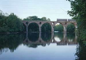 | |
| Road bridge | Cross Keys Road | 40°24′53″N 75°56′23″W | |||
| Road bridge | Wall Street | Leesport | 40°26′44″N 75°58′6″W | ||
| Road bridge | Bellemans Church Road | Leesport and Dauberville | 40°27′24″N 75°58′38″W | ||
| Road bridge | Main Street | Shoemakersville and Mohrsville | 40°28′20″N 75°58′20″W | ||
| Road bridge | Miller Street | Shoemakersville | 40°29′44″N 75°58′17″W | ||
| Berne Bridge | Fisher Dam Road (TR 952) | Berne | 40°31′20″N 75°59′52″W | 1889 truss bridge; 1896 per this website | |
| Road bridge | Hamburg and West Hamburg | 40°33′07″N 75°59′32″W | |||
| Road bridge | State Street | Hamburg and West Hamburg | 40°33′14″N 75°59′25″W | Old US 22 | |
| Rail bridge (converted to trail bridge) | Schuylkill River Trail | Hamburg and West Hamburg | 40°33′20″N 75°59′20″W | Former PRR Schuylkill Branch | |
| Road bridge | Hamburg and West Hamburg | 40°33′37″N 75°59′21″W | |||
Schuylkill County | |||||
| Road bridge | Port Clinton, Tilden Township | 40°34′24.9″N 76°1′10″W | Connects Schuylkill and Berks Counties | ||
| Rail bridge | Reading and Northern | Port Clinton | 40°34′42.7″N 76°1′36.6″W | Yard access to Reading and Northern headquarters, carries Tamaqua branch | |
| Rail bridge | Reading and Northern main line | West Brunswick Township | 40°35′21.8″N 76°4′32.5″W | ||
| Rail bridge (abandoned) | Former Pennsylvania Railroad | West Brunswick Township | 40°35′19.7″N 76°4′32″W | Carried Pennsylvania Railroad (Pennsy) across Schuylkill River then Reading main line | |
| Road bridge (abandoned) | River Road/East Deer View Drive | Auburn | 40°35′5.9″N 76°4′48.9″W | Closed to vehicles in 2000 due to structural deficiencies, still open to pedestrian traffic | |
| Rail bridge | Reading and Northern main line | Auburn | 40°35′15.9″N 76°4′53.4″W | ||
| Road bridge | West Brunswick Township | 40°36′6.7″N 76°5′19.2″W | |||
| Rail bridge | Former Pennsylvania Railroad, now active siding for industry | West Brunswick Township | 40°36′32″N 76°6′7″W | Closed to Pennsy traffic but still carries siding to local factories | |
| Rail bridge | Former Pennsylvania Railroad, now active siding from Reading and Northern | West Brunswick Township | 40°36′41.4″N 76°6′23.6″W | Closed to Pennsy traffic but still carries siding to local factories | |
| Rail bridge | Reading and Northern main line | West Brunswick Township | 40°36′40.4″N 76°6′24″W | ||
| Landingville Dam | West Brunswick Township | 40°36′31.1″N 76°6′22.4″W | Desilting dam | ||
| Rail bridge | Reading and Northern main line | West Brunswick Township | 40°37′13.4″N 76°7′15.9″W | Stone arch construction | |
| Road bridge | Tunnel Road | West Brunswick Township | 40°37′19.2″N 76°7′8.8″W | Wooden deck, single-lane vehicle bridge | |
| Road bridge | Meadow Drive/Main Street | Landingville | 40°37′43″N 76°7′28.5″W | ||
| Rail bridge | Reading and Northern main line | North Manheim Township | 40°37′46″N 76°9′14.9″W | ||
| Road bridge | Schuylkill Haven | 40°37′26.6″N 76°10′29″W | Partially renovated in 2007 |
~ | |
| Rail bridge | Reading and Northern main line | Schuylkill Haven | 40°37′45.8″N 76°10′27.1″W | ||
| Road bridge | Fritz Reed Avenue | Schuylkill Haven | 40°37′59.8″N 76°10′26.4″W | Provides vehicle access to Schuylkill Haven Island Park (Irish Flats) | |
| Rail bridge (abandoned) | Abandoned industrial siding | Schuylkill Haven | 40°38′1.4″N 76°10′48.2″W | ||
| Dam (breached) | Schuylkill Haven | 40°38′1.8″N 76°10′48.3″W | Sunken wood and concrete dam breached in center | ||
| Road bridge | Cressona | 40°38′14.6″N 76°10′57.2″W | |||
| Road bridge | Cressona | 40°38′15.8″N 76°10′59.4″W | |||
| Road bridge | Access to Cressona Mall | Cressona | 40°38′16.9″N 76°11′3.2″W | ||
| Road bridge | Mount Carbon Arch Road | Mount Carbon | 40°40′21.2″N 76°11′8.2″W | ||
| Rail bridge | Reading and Northern main line | Pottsville | 40°40′45.4″N 76°11′20.9″W | ||
| Rail bridge (abandoned) | Former Pennsylvania Railroad | Pottsville | 40°40′52″N 76°11′25.5″W | Concrete arch with no track remaining | |
| Bridge | Pottsville | 40°40′53.5″N 76°11′23.5″W | |||
| Bridge | Access to medical plaza | Pottsville | 40°40′57.1″N 76°11′18.5″W | ||
| Road bridge (abandoned) | Collin Street | Pottsville and Palo Alto | 40°41′0.7″N 76°11′11″W | Closed in 2006, still open to pedestrian traffic, slated for replacement | |

See also


References
- "PENNDOT AWARDS $97.4 MILLION CONTRACT TO REPLACE BRIDGES AND IMPROVE U.S. 422 IN VALLEY FORGE AREA". Pennsylvania Department of Transportation. 26 January 2016. Retrieved 26 May 2016.
- "Turn-of-the-century Bridge Reaches Beginning Of Its End The Betzwood Road Bridge In Upper Merion Is Being Demolished So Penndot Can Replace It. - philly-archives".
- "Sullivan's Bridge construction begins with groundbreaking ceremony; Route 422 bridge project to begin three years early".
- Carl Rotenberg (2016-08-19). "Sullivan's Bridge opens in Valley Forge National Historical Park". The Times Herald, Norristown, Pennsylvania. Retrieved 2016-07-08.
This article is issued from Wikipedia. The text is licensed under Creative Commons - Attribution - Sharealike. Additional terms may apply for the media files.