List of crossings of the River Thames
The River Thames is the second-longest river in the United Kingdom. It is crossed by over 200 bridges, 27 tunnels, six public ferries, one cable car link, and one ford along its 215-mile (346 km) course.

Barrier and boundary
Until sufficient crossings were established, the river provided a formidable barrier for most of its course – in post-Roman Britain during the Dark Ages Belgic-Celtic tribal lands and Anglo-Saxon kingdoms and subdivisions were defined by which side of the river they were on. When English counties were established, the river formed a boundary between the counties on either side. After rising in Gloucestershire, the river flows between, on the north bank, the historic counties of Oxfordshire, Buckinghamshire, Middlesex and Essex; and on the south bank, the counties of Wiltshire, Berkshire, Surrey, and Kent. However the many permanent crossings that have been built over the centuries have changed the dynamics and made cross-river development and shared responsibilities more practicable.
In 1911 Caversham, on the north bank, was transferred into Berkshire. In 1965, with the creation of Greater London, the London Borough of Richmond upon Thames united areas formerly in Middlesex and Surrey; and at the same time two urban districts in Middlesex (united in 1974) became part of Surrey. Further changes in 1974 moved some of the boundaries away from the river. For example, much of the north west of Berkshire including Wallingford, Abingdon and Wantage became part of Oxfordshire, and some southern parts of Buckinghamshire became part of Berkshire, including Slough, Eton and Wraysbury. The number of county councils has dwindled (as well as their area) in south-east and central southern England in favour of increased localisation.[note 1] Despite these changes, in the sports of rowing and skiffing the river banks are still referred to by their traditional county names, and in sports such as football and cricket historic county areas are sometimes used.[note 2]
History of crossings
Many of the present road bridges over the river are on the sites of earlier fords, ferries and wooden structures. The earliest known major crossings of the Thames by the Romans were at London Bridge and Staines Bridge. At Folly Bridge in Oxford the remains of an original Saxon structure can be seen, and medieval stone structures such as Wallingford Bridge, Newbridge and Abingdon Bridge are still in use. Kingston's growth is believed to stem from its having the only crossing between London Bridge and Staines until the beginning of the 18th century. Proposals to build bridges across the Thames at Lambeth and Putney in around 1670 were defeated by the Rulers of the Company of Watermen, since it would mean ruin for the 60,000 rivermen who provided ferry services and also provided a pool of naval reserve.[1]
_by_Claes_Van_Visscher.jpg)
During the 18th century, many stone and brick road bridges were built – from new or to replace existing structures – in London and further up the river. These included Westminster Bridge, Putney Bridge, Datchet Bridge, Windsor Bridge and Sonning Bridge. Several central London road bridges were built in the 19th century, most conspicuously Tower Bridge, the only bascule bridge on the river, designed to allow ocean-going ships to pass beneath it. The most recent road bridge sites are the bypasses at Isis Bridge and Marlow By-pass Bridge and the motorway bridges, most notably the two on the M25: Queen Elizabeth II Bridge and M25 Runnymede Bridge.
The development of the railways resulted in a spate of bridge building in the 19th century, including Blackfriars Railway Bridge and Charing Cross (Hungerford) Railway Bridge in central London, and the spectacular railway bridges by Isambard Kingdom Brunel at Maidenhead, Gatehampton and Moulsford.
The world's first underwater tunnel was the Thames Tunnel by Marc Brunel built in 1843, designed for horse-drawn carriages but used as a pedestrian route; since 1869 the tunnel has carried trains on the East London Line. The Tower Subway (1870) was briefly used for a railway; later came all the deep-level tube lines. Two road tunnels were built in East London at the end of the 19th century, the Blackwall Tunnel and the Rotherhithe Tunnel; and the latest tunnel is the Dartford Crossing.
Many foot crossings were established across the weirs that were built on the non-tidal river, and some of these remained when the locks were built – for example at Benson Lock. Others were replaced by a footbridge when the weir was removed, as at Hart's Weir Footbridge. Around the year 2000, several footbridges were added, either as part of the Thames Path or in commemoration of the Millennium. These include Temple Footbridge, Bloomers Hole Footbridge, the Hungerford Footbridges and the Millennium Bridge, all of which have distinctive designs.
Some ferries still operate on the river. The Woolwich Ferry carries cars and passengers across the river in the Thames Gateway and links the North Circular and South Circular roads. Upstream are smaller pedestrian ferries, for example Hampton Ferry and the Shepperton to Weybridge Ferry; the latter is the only non-permanent crossing that remains on the Thames Path.
Note on the listing
The list starts at the downstream (estuary) end and follows the river upstream towards the source. A few of the crossings listed are public pedestrian crossings using walkways across lock gates and bridges above or adjacent to the adjoining weirs. Most of the other locks on the River Thames also have walkways across their lock gates and weirs, but these either do not completely cross the river, or are restricted to authorised personnel only, and are therefore not listed. Crossings listed in italics are inaccessible to the public. Besides the ferry crossings listed, there are commuter boat services operating along the river in London, and tourist boat services operating both in London and upstream. Whilst the principal purpose of these services is not to carry people across the river, it may be possible to use them to do so.
North Sea to London
| Crossing | Type | Co-ordinates | Date opened | Notes |
|---|---|---|---|---|
| Thames Cable Tunnel | Utility tunnel | 51°26′35″N 0°24′22″E | 1970 | Carries two 400kV circuits;[2][3] accessible by authorised personnel only |
| Gravesend–Tilbury Ferry | Passenger ferry | 51°26′55″N 0°22′3″E | 1571 or before[4] | |
| High Speed 1 tunnels | Rail tunnel | 51°27′46″N 0°17′37″E | 2007 | Two 2.5 km tunnels, 7.15 m internal diameter, between West Thurrock (Essex) and Swanscombe (Kent) |
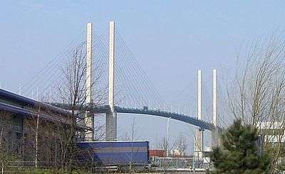
| Queen Elizabeth II Bridge | Road bridge | 51°27′52″N 0°15′31″E | 1991 | Cable-stayed bridge - the southbound element of the Dartford Crossing |
| Dartford Tunnels | Road tunnels | 51°27′55″N 0°15′27″E | 1963 and 1980 | The northbound element of the Dartford Crossing |
| Dartford Cable Tunnel | Utility tunnel | 51°28′5″N 0°14′58″E | 2005 | Carrying electrical cable; accessible by authorised personnel only |
Proposed
A Lower Thames Crossing is proposed, at or east of the Dartford Crossing. Three options were announced in April 2009.
East London
| Crossing | Type | Co-ordinates | Date opened | Notes |
|---|---|---|---|---|
| Barking cable tunnel | Utility tunnel | 51.51311N 0.10858E | about 1925[5] | Carries four 33 kV electricity circuits from Barking substation to Sewell Road substation, Thamesmead[6] |
| Docklands Light Railway tunnel | Rail tunnel | 51°29′55″N 0°4′31″E | 2009 | Between King George V and Woolwich Arsenal stations |
| Woolwich foot tunnel | Pedestrian tunnel | 51°29′47″N 0°3′45″E | 1912 | |
| Woolwich Ferry | Vehicle ferry | 51°29′47″N 0°3′44″E | 1889 | |
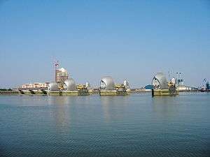
| Thames Barrier | Flood barrier with pedestrian tunnel | 51°29′49″N 0°2′14″E | 1984 | Service tunnel accessible by authorised personnel only |
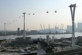
| Emirates Air Line | Gondola lift | 51°30′05″N 0°0′45″E | 2012 | |
| Millennium Dome electricity cable tunnel | Utility tunnel | 1999[7] | Accessible by authorised personnel only | |
| Jubilee line tunnels | Rail tunnel | 51°30′17″N 0°0′31″E | 1999 | Between North Greenwich and Canning Town stations. |
| Blackwall Tunnel (eastern) | Road tunnel | 51°30′19″N 0°0′7″W | 1967 | For southbound vehicular traffic only |
| Blackwall Tunnel (western) | Road tunnel | 51°30′13″N 0°0′14″W | 1897 | For northbound vehicular traffic only |
| Jubilee line tunnels | Rail tunnel | 51°30′1″N 0°0′19″W | 1999 | Between Canary Wharf and North Greenwich stations. |
| Greenwich foot tunnel | Pedestrian tunnel | 51°29′6″N 0°0′35″W | 1902 | |
| Deptford cable tunnel | Utility tunnel | 51.48642N 0.02169W | Carries 30 11 kV electricity circuits[8] | |
| Docklands Light Railway tunnel | Rail tunnel | 51°29′5″N 0°0′37″W | 1999 | Between Island Gardens and Cutty Sark stations. |
| Jubilee line tunnels | Rail tunnel | 51°30′2″N 0°1′48″W | 1999 | Between Canada Water and Canary Wharf stations. |
| Canary Wharf – Rotherhithe Ferry | Passenger ferry | 51°30′19″N 0°1′47″W | ||
| Rotherhithe Tunnel | Road tunnel | 51°30′23″N 0°2′55″W | 1908 | Single carriageway in each direction, with footways on each side. Built originally for horse-drawn carriages. Pedestrians, riders, cyclists are permitted, but advised to use alternatives due to fumes and speed. |
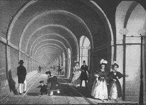
| Thames Tunnel | Rail tunnel | 51°30′11″N 0°3′16″W | 1843 | The world's first underwater tunnel, linking Wapping to Rotherhithe. Originally designed as a road tunnel for horse-drawn traffic, the necessary access ramps were never built and it was opened as a pedestrian tunnel. It was converted to a rail tunnel, reopening in 1869 and becoming part of the London Overground network in 2010. |
| New Cross to Finsbury Market Cable Tunnel | Utility tunnel | 51.5026N 0.06222W | 2017 | Carries three 132 kV electricity circuits[9] |
Proposed or under construction
- A new rail tunnel is being constructed between Plumstead and North Woolwich as part of Crossrail 1.[10]
- The Silvertown Tunnel is a proposed tunnel to relieve the Blackwall Tunnels between the Greenwich Peninsula and West Silvertown.
- The Gallions Reach Crossing is a proposed tunnel or bridge, between Beckton and Thamesmead.[11]
- The Belvedere Crossing is a proposed tunnel or bridge, between Belvedere and Rainham.[11]
- A pedestrian and cycle bridge between Rotherhithe and Canary Wharf has been proposed.
Central London


| Crossing | Type | Co-ordinates | Date opened | Notes |
|---|---|---|---|---|
| Tower Bridge | Road bridge | 51°30′20″N 0°4′32″W | 1894 | |
| Tower Subway | Utility tunnel | 51°30′24″N 0°4′46″W | 1870 | Formerly an underground railway - now used for water mains and telephone cables and accessible only by authorised personnel |
| Northern line (City branch) tunnels | Rail tunnel | 51°30′28″N 0°5′13″W | 1900 | Between London Bridge and Bank |
| London Bridge | Road bridge | 51°30′28″N 0°5′16″W | 1973 | Other bridges have stood on or near this site since around AD 50 |
| City & South London Railway tunnels | Disused rail tunnel | 51°30′29″N 0°5′20″W | 1890 | This railway's original crossing of the river between Borough and King William Street; abandoned in 1900 when the Northern line City branch tunnels were opened on a new alignment |
| Cannon Street Railway Bridge | Rail bridge | 51°30′30″N 0°5′31″W | 1982 | |
| Southwark Bridge | Road bridge | 51°30′32″N 0°5′39″W | 1921 | |
| London Millennium Footbridge | Pedestrian bridge | 51°30′35″N 0°5′55″W | 2000 | |
| Bankside Cable Tunnel | Utility tunnel | 51.50904N 0.09873W | c.1947 | East of Blackfriars rail bridge, 132 kV and 33 kV electricity circuits[12] |
| Blackfriars Railway Bridge | Rail bridge | 51°30′35″N 0°6′12″W | 1886 | |
| Blackfriars Bridge | Road bridge | 51°30′35″N 0°6′16″W | 1869 | |
| Waterloo & City line tunnels | Rail tunnel | 51°30′35″N 0°6′20″W | 1898 | Between Waterloo and Bank |
| Waterloo Bridge | Road bridge | 51°30′31″N 0°7′1″W | 1945 | |
| Northern line (Charing Cross branch) tunnels | Rail tunnel | 51°30′23″N 0°7′10″W | 1926 | Between Waterloo and Embankment |
| Hungerford Bridge and Golden Jubilee Bridges | Rail and pedestrian bridges | 51°30′22″N 0°7′13″W | 1864 and 2002 | Rail bridge flanked by newer pedestrian bridges |
| Bankside – Charing Cross cable tunnel | Utility tunnel | 51.50501N 0.11586W | Underneath Hungerford Bridge[12] | |
| Bakerloo line tunnels | Rail tunnel | 51°30′20″N 0°7′14″W | 1906 | Between Waterloo and Embankment |
| Jubilee line tunnels | Rail tunnel | 51°30′4″N 0°7′18″W | 1999 | Between Waterloo and Westminster |
| Westminster Bridge | Road bridge | 51°30′3″N 0°7′19″W | 1862 | |
| Lambeth Bridge | Road bridge | 51°29′40″N 0°7′21″W | 1932 | |
| Vauxhall Bridge | Road bridge | 51°29′15″N 0°7′37″W | 1906 | |
| Victoria line tunnels | Rail tunnel | 51°29′14″N 0°7′39″W | 1971 | Between Vauxhall and Pimlico |
| Wimbledon – Pimlico cable tunnel | Utility tunnel | 51.4848N 0.12671W | Electricity cables[13] | |
| Battersea steam tunnel | Utility tunnel | 51°29′03″N 0°8′31″W | 20th century | Between Battersea and Pimlico is a single tunnel carrying four pipes, two 30" Thames Water mains and two 11" pipes feeding the Pimlico District Heating system, originally powered by Battersea Power Station. |
| Battersea exhaust tunnels | Utility tunnel | 51°29′02″N 0°8′48″W | 20th century | Between Battersea and either side of Victoria are two tunnels. Tunnels are labelled 'A' and 'B'; A splits further to become 'C' under Ranelagh Gardens. |
| Grosvenor Bridge | Rail bridge | 51°29′5″N 0°8′50″W | 1859 | Also known as Victoria Railway Bridge |
Former
- At least two Emergency Thames Bridges were erected as a precaution against enemy action during World War II. The first of these bridges was built from Victoria Embankment to County Hall, London and was constructed in 1942[14] before being demolished in 1948.[15] The second such bridge was constructed at Millbank outside the Tate Britain in 1942[16] before also being dismantled in 1948.[17]
South West London


| Crossing | Type | Co-ordinates | Date opened | Notes |
|---|---|---|---|---|
| Chelsea Bridge | Road bridge | 51°29′4″N 0°8′59″W | 1937 | |
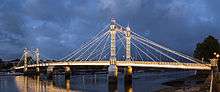
| Albert Bridge | Road bridge | 51°28′56″N 0°10′0″W | 1873 | |
| Battersea Bridge | Road bridge | 51°28′52″N 0°10′21″W | 1890 | Replaced an earlier bridge, opened in 1771 |
| Battersea Railway Bridge | Rail bridge | 51°28′23″N 0°10′45″W | 1863 | West London Line. Also called the Cremorne Bridge. |
| Wandsworth Bridge | Road bridge | 51°27′54″N 0°11′16″W | 1938 | |
| London Power Tunnels Wimbledon - Kensal Green | Utility Tunnel | 51°27′47″N 0°11′35″W | 2018 | |
| Fulham Railway Bridge | Rail and pedestrian bridge | 51°27′57″N 0°12′35″W | 1889 | |
| Putney Bridge | Road bridge | 51°28′1″N 0°12′46″W | 1886 | Replaced an earlier bridge, known as Fulham Bridge, opened in 1729 |
| Hammersmith Bridge | Road bridge | 51°29′18″N 0°13′49″W | 1887 | As of April 2019, Hammersmith Bridge is closed to traffic. Pedestrians and bikes can still use the bridge to cross the river. |
| Barnes Railway Bridge | Rail and pedestrian bridge | 51°28′22″N 0°15′14″W | 1849 | |
| Chiswick Bridge | Road bridge | 51°28′23″N 0°16′11″W | 1933 | |
| Kew Railway Bridge | Rail bridge | 51°29′3″N 0°16′45″W | 1869 | |
| Kew Bridge | Road bridge | 51°29′14″N 0°17′15″W | 1903 | |
| Richmond Lock and Footbridge | Lock with pedestrian bridge | 51°27′44″N 0°19′2″W | 1894 | |
| Twickenham Bridge | Road bridge | 51°27′38″N 0°18′51″W | 1933 | |
| Richmond Railway Bridge | Rail bridge | 51°27′36″N 0°18′49″W | 1848 | |
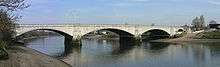
| Richmond Bridge | Road bridge | 51°27′27″N 0°18′25″W | 1777 | |
| Hammerton's Ferry | Passenger ferry | 51°26′48″N 0°18′51″W | 1909 | From Marble Hill House (Twickenham) to Ham House (Ham) |
| Teddington Lock Footbridges | Pedestrian bridges | 51°25′49″N 0°19′19″W | 1889 | |
| Kingston Railway Bridge | Rail bridge | 51°24′49″N 0°18′30″W | 1863 | |
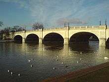
| Kingston Bridge | Road bridge | 51°24′40″N 0°18′33″W | 1828 | |
| Hampton Court Bridge | Road bridge | 51°24′13″N 0°20′33″W | 1933 | From Hampton Court to East Molesey |
| Hampton Ferry | Passenger ferry | 51°24′43″N 0°21′45″W | 1519 | From Hampton to Hurst Park, East Molesey |
Planned
- Diamond Jubilee Footbridge, a pedestrian bridge adjacent to Battersea Railway Bridge, granted planning permission in 2013.
London to Windsor


| Crossing | Type | Co-ordinates | Date opened | Notes |
|---|---|---|---|---|
| Walton Bridge | Road bridge | 51°23′15″N 0°25′53″W | 2013 | |
| Shepperton to Weybridge Ferry | Passenger ferry | 51°22′56″N 0°27′25″W | 16th century | The only ferry specifically part of the Thames Path and the most upstream operating ferry |
| Chertsey Bridge | Road bridge | 51°23′20″N 0°29′11″W | 1785 | |
| M3 Chertsey Bridge | Road bridge | 51°23′39″N 0°29′11″W | 1971 | Carrying the M3 motorway |
| Staines Railway Bridge | Rail bridge | 51°25′50″N 0°30′40″W | 1856 | Built by the London and South Western Railway. Carries the Waterloo to Reading Line. |
| Staines Bridge | Road bridge | 51°26′0″N 0°31′1″W | 1832 | Bridges continuously recorded near this site since 1228. |
| M25 Runnymede Bridge | Road bridge | 51°26′0″N 0°31′1″W | 1961 | Carrying the M25 motorway and, on the older part of the bridge, the A30; widened in 1983 and 2005 |
| Albert Bridge | Road bridge | 51°28′16″N 0°35′4″W | 1928 | Replaced a cast-iron bridge built in 1850-51 |
| Victoria Bridge | Road bridge | 51°29′16″N 0°35′29″W | 1967 | Replacing an 1851 bridge |
| Black Potts Railway Bridge | Rail bridge | 51°29′33″N 0°35′50″W | 1850 | |
| Windsor Bridge | Pedestrian and cycle bridge | 51°29′9″N 0°36′30″W | 1850 | Formerly used as a road bridge |
| Windsor Railway Bridge | Rail bridge | 51°29′13″N 0°37′5″W | 1849 | |
| Queen Elizabeth Bridge | Road bridge | 51°29′13″N 0°37′22″W | 1966 |
Former
- The Datchet Bridge, built in 1707, was demolished in 1848, and replaced by the Albert and Victoria bridges.
Windsor to Reading
| Crossing | Type | Co-ordinates | Date opened | Notes |
|---|---|---|---|---|
| Summerleaze Footbridge | Pedestrian bridge | 51°29′59″N 0°40′54″W | 1992 | |
| M4 Thames Bridge | Road bridge | 51°30′25″N 0°41′10″W | 1961 | Carrying the M4 Motorway; incorporates a footbridge |
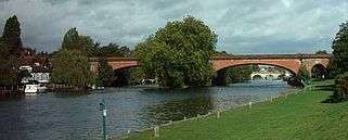
| Maidenhead Railway Bridge | Rail bridge | 51°31′16″N 0°42′6″W | 1838 | Carrying the Great Western Main Line. |
| Maidenhead Bridge | Road bridge | 51°31′25″N 0°42′7″W | 1777 | Bridge recorded 1280. |
| Cookham Bridge | Road bridge | 51°33′44″N 0°42′22″W | 1867 | |
| Bourne End Railway Bridge | Rail and pedestrian bridge | 51°34′30″N 0°42′51″W | 1895 | Footbridge added specifically for the Thames Path |
| Marlow By-pass Bridge | Road bridge | 51°33′58″N 0°45′43″W | 1972 | |
| Marlow Bridge | Road bridge | 51°34′2″N 0°46′23″W | 1832 | Replaced bridge built in 1530. |
| Temple Footbridge | Pedestrian bridge | 51°33′5″N 0°47′49″W | 1989 | Temple Footbridge was built in 1989 specifically for the Thames Path |
| Hambleden Lock | Lock and pedestrian bridge | 51°33′34″N 0°52′19″W | 1884 | |
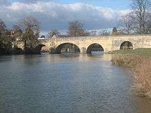
| Henley Bridge | Road bridge | 51°32′15″N 0°54′1″W | 1786 | Earlier bridge dates from at least 1232. |
| Shiplake Railway Bridge | Rail bridge | 51°30′7″N 0°52′41″W | 1897 | |
| Sonning Bridge and Sonning Backwater Bridges | Road bridges | 51°28′34″N 0°54′54″W | c. 1775 and 1986 | Earlier bridge recorded 1530 and one in 1125 |
| Caversham Lock | Lock and pedestrian bridge | 51°27′40″N 0°57′54″W | 1875 | |
| Reading Bridge | Road bridge | 51°27′39″N 0°58′4″W | 1923 | |
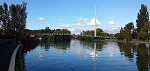
| Christchurch Bridge | Pedestrian and cycle bridge | 51°27′45″N 0°58′14″W | 2015 | |
| Caversham Bridge | Road bridge | 51°27′57″N 0°58′38″W | 1926 | Earliest bridge on site recorded in 1231. |
Reading to Oxford

| Crossing | Type | Co-ordinates | Date opened | Notes |
|---|---|---|---|---|
| Reading Festival Bridge | Pedestrian bridge (intermittently present) | 51°28′2″N 1°0′43″W | 2008 | Temporarily erected each year on permanent footings for the period of the annual Reading Festival; accessible to festival ticket-holders and other authorised personnel only |
| Whitchurch Bridge | Road bridge | 51°29′13″N 1°5′6″W | 1902 | Toll bridge |
| Gatehampton Railway Bridge | Rail bridge | 51°30′42″N 1°7′40″W | 1838 | |
| Goring and Streatley Bridge | Road bridge | 51°31′23″N 1°8′33″W | 1923 | |
| Moulsford Railway Bridge | Rail bridge | 51°33′29″N 1°8′33″W | 1838 | |
| Winterbrook Bridge | Road bridge | 51°35′18″N 1°7′25″W | 1993 | |
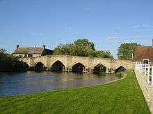
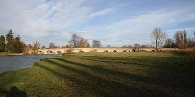
| Wallingford Bridge | Road bridge | 51°36′3″N 1°7′14″W | 1809 | Bridge recorded 1141. |
| Benson Lock bridge | Lock and pedestrian bridge | 51°36′59″N 1°6′55″W | ||
| Shillingford Bridge | Road bridge | 51°37′27″N 1°8′22″W | 1827 | Replaced bridge built 1763. |
| Little Wittenham Bridge | Pedestrian bridge | 51°38′14″N 1°10′49″W | 1870 | |
| Day's Lock bridges | Pedestrian bridges | 51°38′19″N 1°10′47″W | ||
| Clifton Hampden Bridge | Road bridge | 51°39′16″N 1°12′38″W | 1867 | |
| Appleford Railway Bridge | Rail bridge | 51°38′38″N 1°14′25″W | 1929 | |
| Sutton Bridge | Road bridge | 51°38′59″N 1°15′56″W | 1807 | |
| Footbridges at Sutton Pools | Footbridges | 51°38′45″N 1°16′24″W | Linking four islands in the river course | |
| Culham Lock bridges | Pedestrian bridges | 51°38′58″N 1°16′24″W | A bridge across the weir on the Culham Cut, west of Culham Lock; further south, other bridges cross the main river channel | |
| Abingdon Bridge | Road bridge | 51°40′7″N 1°16′46″W | 1416 | |
| Abingdon Lock | Lock and pedestrian bridges | 51°40′15″N 1°16′11″W | ||
| Nuneham Railway Bridge | Rail bridge | 51°40′9″N 1°14′27″W | 1929 | |
| Sandford Lock | Lock and pedestrian bridges | 51°42′30″N 1°13′58″W | ||
| Kennington Railway Bridge | Rail bridge | 51°43′16″N 1°14′32″W | 1923 | |
| Isis Bridge | Road bridge | 51°43′30″N 1°14′29″W | 1962 | |
| Iffley Lock | Lock and pedestrian bridges | 51°43′46″N 1°14′24″W | ||
| Donnington Bridge | Road bridge | 51°44′8″N 1°14′31″W | 1962 | |
| Folly Bridge | Road bridge | 51°44′46″N 1°15′23″W | 1827 | Stone bridge built 1085 |
| Grandpont Bridge | Pedestrian bridge | 51°44′49″N 1°15′39″W | 1930s | |
| Gasworks Bridge | Pedestrian bridge | 51°44′46″N 1°15′49″W | 1882 | Originally built to carry a rail line to the Oxford Gasworks, which closed in 1960. |
| Osney Rail Bridge | Rail bridge | 51°44′49″N 1°16′1″W | 1850 and 1887 | Two adjacent bridges |
| Osney Bridge | Road bridge | 51°45′9″N 1°16′21″W | 1885 |
Oxford to Cricklade

| Crossing | Type | Co-ordinates | Date opened | Notes |
|---|---|---|---|---|
| Medley Footbridge | Pedestrian bridge | 51°45′50″N 1°16′49″W | 1865 | |
| Godstow Bridge | Road bridge | 51°46′47″N 1°17′59″W | 1792 | A previous bridge was held by the Royalists in 1645. |
| A34 Road Bridge | Road bridge | 51°46′51″N 1°18′11″W | 1961 | |
| King's Lock | Lock and pedestrian bridge | |||
| Eynsham Lock | Lock and pedestrian bridge | Permissive | ||
| Swinford Toll Bridge | Road bridge | 51°46′28″N 1°21′33″W | 1777 | |
| Pinkhill Lock | Lock and pedestrian bridge | 51°45′37″N 1°21′52″W | ||
| Hart's Weir Footbridge | Pedestrian bridge | 51°42′24″N 1°23′36″W | 1879 | |
| Newbridge | Road bridge | 51°42′35″N 1°25′2″W | 1250[19] | |
| Duxford Ford and Shifford Lock Cut footbridge | Ford and pedestrian bridge | 51°41′55″N 1°27′58″W and 51°42′18″N 1°28′14″W | The ford crosses the original river channel to an island formed on its other side by the Shifford Lock Cut, which is crossed by a footbridge. There is no footbridge across the original river channel, which must be forded by pedestrians. | |
| Tenfoot Bridge | Pedestrian bridge | 51°41′38″N 1°29′23″W | 1869 | |
| Tadpole Bridge | Road bridge | 51°42′5″N 1°31′2″W | 1784 | |
| Rushey Lock | Lock and pedestrian bridge | 51°41′54″N 1°32′4″W | ||
| Old Man's Bridge | Pedestrian bridge | 51°41′59″N 1°34′5″W | 1868 | |
| Radcot Bridge | Road bridge | 51°41′36″N 1°35′19″W | 1787 | |
| Eaton Footbridge | Pedestrian bridge | 51°41′6″N 1°38′41″W | 1936 | |
| Buscot Lock | Lock and pedestrian bridge | 51°40′52″N 1°40′6″W | ||
| Bloomers Hole Footbridge | Pedestrian bridge | 51°41′15″N 1°40′31″W | 2000 | Built in 2000 for the Thames Path |
| St. John's Bridge | Road bridge | 51°41′22″N 1°40′44″W | 1886 | |
| Halfpenny Bridge | Road bridge | 51°41′32″N 1°41′34″W | 1792 | The upstream limit of the navigable Thames |
| Round House Footbridge | Pedestrian bridge | 51°41′18″N 1°42′16″W | The original towpath extends upstream to this point, by the connection with the now disused Thames and Severn Canal | |
| Hannington Bridge | Road bridge | 51°39′48″N 1°44′57″W | 1841 | |
| Castle Eaton Bridge | Road bridge | 51°39′39″N 1°47′33″W | 1893 | |
| Water Eaton House Bridge | Pedestrian bridge | 51°38′39″N 1°49′21″W | ||
| Eysey Footbridge | Pedestrian bridge | 51°38′43″N 1°50′18″W | ||
| A419 Road Bridge | Road bridge | 51°38′34″N 1°50′43″W | 1988 | |
| Cricklade sewage works bridge | Road bridge | 51°38′36″N 1°51′5″W | Access road to sewage works, accessible to authorised personnel only | |
| Cricklade Town Bridge | Road bridge | 51°38′40″N 1°51′17″W | 1852 |
Cricklade to the source
Not all of the bridges above Cricklade are listed below. For example, there are a number of small agricultural bridges allowing access between fields, and bridges to properties in Ashton Keynes that are not mentioned.
| Crossing | Type | Co-ordinates | Notes |
|---|---|---|---|
| Footbridge | Pedestrian bridge | 51°39′5″N 1°52′31″W | |
| Midland and South Western Junction Railway bridge | Pedestrian and cycle bridge | 51°39′5″N 1°52′31″W | Formerly a rail bridge |
| Footbridge at Hailstone House | Pedestrian bridge | 51°38′57″N 1°53′11″W | |
| Manor Farm bridge | Road bridge | 51°38′24″N 1°54′10″W | North of Manor Farm, Waterhay |
| Brook Farm bridge | Road bridge | 51°38′23″N 1°54′14″W | North of Brook Farm, Waterhay |
| Waterhay Bridge | Road bridge | 51°38′17″N 1°54′53″W | |
| Footbridge | Pedestrian bridge | 51°38′20″N 1°55′25″W | |
| Bridge on High Road, Ashton Keynes | Road bridge | 51°38′25″N 1°55′51″W | |
| Bridge on The Derry, Ashton Keynes | Road bridge | 51°38′30″N 1°55′56″W | |
| Bridge on Gosditch, Ashton Keynes | Road bridge | 51°38′42″N 1°56′7″W | |
| Bridge on Church Walk, Ashton Keynes | Road bridge | 51°38′48″N 1°56′10″W | |
| Bridge on Church Lane, Ashton Keynes | Road bridge | 51°38′48″N 1°56′14″W | |
| Bridge on B4696, Ashton Keynes | Road bridge | 51°38′46″N 1°56′31″W | |
| Bridges | Road bridge and pedestrian bridge | 51°38′46″N 1°56′56″W | |
| Bridge | Road bridge | 51°38′43″N 1°57′38″W | |
| Footbridge | Pedestrian bridge | 51°38′48″N 1°57′46″W | |
| Bridge | Road bridge | 51°38′51″N 1°57′58″W | |
| Bridge | Road bridge | 51°38′52″N 1°58′2″W | |
| Bridge | Road bridge | 51°38′54″N 1°58′8″W | |
| Footbridge | Pedestrian bridge | 51°38′59″N 1°58′17″W | |
| Bridge | Road bridge | 51°39′2″N 1°58′24″W | |
| Neigh Bridge | Road bridge | 51°39′6″N 1°58′29″W | |
| Bridge south of Ewen | Road bridge | 51°40′27″N 1°59′44″W | |
| Parker's Bridge, Ewen | Road bridge | 51°40′31″N 2°0′25″W | |
| A429 Road Bridge | Road bridge | 51°40′47″N 2°0′53″W | Demolished bridge on the currently closed Cirencester Branch Line ran over the road. Part of the Beeching Axe legacy. |
| A433 Road Bridge, Fosse Way Roman Road | Road bridge | 51°41′24″N 2°1′21″W | At Thames Head |
The river splits as it passes through Ashton Keynes. An alternative route to that listed above crosses High Bridge at 51°38′13″N 1°55′46″W and Three Bridges at 51°38′18″N 1°56′21″W.
See also
Notes
- For example Berkshire County Council and Middlesex County Council were abolished and smaller authorities have been created in the counties adjoining the Thames, from the Borough of Swindon unitary authority to Medway Council on the Thames Estuary.
- e.g. Buckinghamshire County Cricket Club, Middlesex County Football Association and Middlesex County Cricket Club
References
- "Parishes: Putney - British History Online". www.british-history.ac.uk.
- Anon (May 1970). "Cables Down Under". Electronics & Power. 16 (5): 175. doi:10.1049/ep.1970.0161.
- Haswell, C.K. (December 1969). "Thames Cable Tunnel". Proceedings of the Institution of Civil Engineers. 44 (4): 323–430. doi:10.1680/iicep.1969.7250.
- Map drawn by a one-time Portreve (Mayor) of Gravesend, William Bourne, and included in The Book of Gravesham Sydney Harker, 1979 ISBN 0 86023 091 0]
- "Barking power station". Historic England. Retrieved 20 March 2020.
- "Open Infrastructure Map". Open Infrastructure Map. Retrieved 20 March 2020.
- Field, Gary (January 2000). "Monitoring settlement in London Clay". Converting Today. Archived from the original on 29 July 2012. Retrieved 22 April 2012.
- "Open Infrastructure Map". Open Infrastructure Map. Retrieved 20 March 2020.
- "Open Infrastructure Map". Open Infrastructure Map. Retrieved 20 March 2020.
- "Hochtief and Vinci win last Crossrail tunnels". The Construction Index. Retrieved 22 April 2012.
- "Gallions Reach and Belvedere river crossings - Consultation report and responses to key issues raised" (PDF). Transport for London. March 2016.
- "Open Infrastructure Map". Open Infrastructure Map. Retrieved 23 March 2020.
- "Open Infrastructure Map". Open Infrastructure Map. Retrieved 23 March 2020.
- "Emergency Thames Bridge: Victoria Embankment to County Hall, construction work in progress". City of London Corporation. Archived from the original on 6 November 2015. Retrieved 28 March 2013.
- "Emergency Thames Bridge: Victoria Embankment to County Hall, demolition work in progress". City of London Corporation. Archived from the original on 6 November 2015. Retrieved 28 March 2013.
- "Emergency Thames Bridge: Millbank site, construction work in progress". City of London Corporation. Archived from the original on 6 November 2015. Retrieved 28 March 2013.
- "Emergency Thames Bridge: Millbank site, structure is dismantled". City of London Corporation. Archived from the original on 6 November 2015. Retrieved 28 March 2013.
- "London bridge designs unveiled". 21 July 2015 – via www.bbc.co.uk.
- Thacker, Fred. S. (1920). "The Thames Highway". 2, Locks and Weirs: 77. Cite journal requires
|journal=(help)
Further reading
- Tucker, Joan (2012). Ferries of the Upper Thames. Amberley Publishing. ISBN 978-1-84868-967-1.
External links
