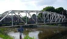
Grandpont Bridge
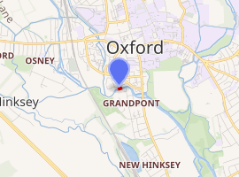
Grandpont Bridge is a footbridge across the River Thames near the centre of Oxford, England. It links Friars Wharf in St Ebbes on the north bank to the Geoffrey Arthur Building of Pembroke College, built in 1990,[2] and the Grandpont area. It crosses the Thames on the reach between Iffley Lock and Osney Lock.
Grandpont Bridge | |
|---|---|
 | |
| Coordinates | 51.747134°N 1.260942°W |
| Carries | Footpath, Cycleway |
| Crosses | River Thames |
| Locale | Oxford |
| Characteristics | |
| Material | Iron |
| Height | 12 feet 0 inches (3.66 m)[1] |
| |
The bridge is also used by cyclists. It lies on the Hanson Way, part of National Cycle Network route 5.[3]
The Environment Agency refers to the bridge as "Grandpont Bridge".[4] Another source also calls the bridge "Oxford footbridge".[5]
The bridge was built in the 1930s.[6] The bridge only carried a utility pipe and lacked a walkway in 1977.[7]
The bridge takes its name from Grandpont, the area south of the bridge, which itself takes its name from a much earlier bridge-causeway which included the next bridge downstream, now known as Folly Bridge.
References
- River Thames Alliance. Bridge heights on the River Thames.
- Pembroke College website
- "Sustrans: The Hanson Way" (PDF). Archived from the original (PDF) on 6 February 2011. Retrieved 13 March 2011.
- Environment Agency: Users Guide to the Thames, p.41
- 'Where Thames Smooth Waters Glide'
- The 1936 Ordnance Survey map shows no bridge. An aerial view from the 1930s shows the bridge, in The Changing Faces of St Ebbe's and St Thomas, Book One ISBN 1-899536-17-5, page 29.
- Curl, James Stevens (1977). The Erosion of Oxford. Oxford Illustrated Press. p. 117. ISBN 0-902280-40-6.
See also
- Crossings of the River Thames
| Next crossing upstream | River Thames | Next crossing downstream |
| Gasworks Bridge (pedestrian) | Grandpont Bridge | Folly Bridge (road) |