List of axial multiple-stone circles
An axial stone circle is a particular type of megalithic ring of stones of which many are found in southwest Ireland. Archaeologists have found it convenient to consider axial five-stone circles and axial multiple-stone circles separately – this list is of multiple-stone circles, those with seven stones or more. They have an approximate axis of symmetry aligned in a generally northeast–southwest direction – the stone at the southwest side of the circle, rather than being an upright orthostat like all the rest, rests on the ground with its long axis horizontal. Because it marks the axis it is called the axial stone. It is usually quite thin and it lies with its long thin edge along the circumference of the ring.[1][2]
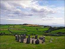
Dating from the Bronze Age, axial stone circles when constructed had an odd number of stones with two stones (portal stones) placed on either side of where the axis crosses the northeast side of the ring. They are found in County Cork and County Kerry.[3][4][5]
Early in the 20th century they were called recumbent stone circles by analogy with similar examples in Scotland but when it became clear there were substantial differences the term "Cork–Kerry stone circle" was adopted.[6] The term "axial stone circle" has since become frequently used leaving it unclear whether both types or only the multiple type is meant.
Ó Nualláin (1984) has published a comprehensive catalogue of stone circles in the two counties and Burl followed with two books, Burl (1995) and Burl (2000), covering a much broader area but still including this type of circle. Ireland's National Monuments Service, part of the Department of Culture, Heritage and the Gaeltacht, operates a database of archaeology sites and the list in this article covers the sites classified as "stone circle – multiple-stone".[7] The NMS definition is:
Stone circle - multiple-stone
A distinctive form of stone circle found only in counties Cork and Kerry. It comprises a ring of free-standing stones, uneven in number (between 7 and 19) and symmetrically arranged so that one stone, the axial stone, is set directly opposite two stones, usually the tallest, marking the entrance to the circle. Characteristically, the stones reduce in height to the axial stone, which is set consistently in the south-western part of the circle. The diameters of these circles rarely exceed 10m. These circles form part of the funerary/ritual tradition of the Bronze Age (c. 2400-500 BC).
— National Monuments Service, Class List Definitions, "Stone circle - multiple-stone". National Monuments Service: Archaeological Survey of Ireland.
Included are 41 sites in County Cork, 15 in County Kerry and a single one in County Clare.[7]
List of axial multiple-stone circles
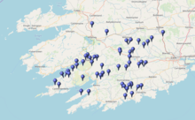
The map shows the locations of the 56 sites in counties Cork and Kerry (an additional site in County Clare is off the map). All the locations can be displayed dynamically via the OpenStreetMap viewer.
| Townland[n 1] | SMR No.[n 2] | Ref.[n 3] | Diameter (metre)[n 4] |
Num. stones[n 5] | Status[n 6] Notes |
Lat/long[n 7] | Irish Grid[n 8] |
|---|---|---|---|---|---|---|---|
| Ahagilla | CO121-100---- | 7 | 3/?[7] | ruin | 51.641°N 8.963°W | W 334 436 | |
| An Dromaid (Dromod) | KE089-053---- | (39 8) | 4 | 5/7*[n 9] | ruin | 51.857°N 10.115°W | V 544 693 |
| Ardgroom SW | CO102-006001- | 302 (21 9) | 7.3 | 10/11 | good | 51.736°N 9.87°W | V 709 553 |
| Ardgroom NE | CO102-010---- | 302 (20 8) | 3/5+ | gone | 51.746°N 9.856°W | V 719 565 | |
| Ballyvackey | CO135-005001- | (35 3) | 8.5 | 7/9* | ruin | 51.633°N 8.948°W | W 344 427 |
| Bohonagh | CO143-032001- | 304 (36 1) | 9.9 | 13 | good excav.[10] | 51.581°N 9°W | W 308 369 |
| Breeny More | CO106-005001- | 305 (24 6 | 14 | 5+ | gone | 51.742°N 9.375°W | W 510 553 |
| Cappanaboul | CO105-029001- | (22 5) | 10.5 | 10/13* | ruin | 51.724°N 9.398°W | W 340 533 |
| Carrigagrenane (SW) | CO134-008---- | 308 (33 3) | 8.5 | 13/19[11] | ruin | 51.637°N 9.078°W | W 254 432 |
| Carrigagulla (SW) | CO049-008---- | 310 (4 4) | 9 | 15/17* | ruin | 52°N 8.916°W | W 371 835 |
| Carrigaphooca | CO070-035---- | (11 4) | 5.5 | 5+ | gone | 51.909°N 9.025°W | W 295 735 |
| Cashelkeelty (W) | KE108-013001- | 344 (47 -) | 17 | 3/11 or 13 | gone excav.[12] | 51.757°N 9.815°W | V 747 576 |
| Coolaclevane | CO082-066---- | (13 3) | 7.5 | 9 | ruin | 51.824°N 9.035°W | W 287 640 |
| Coollick | KE058-134---- | 10/?[7] | good[7] | 52.133°N 9.509°W | V 967 989 | ||
| Coolmountain | CO093-013---- | (17 8) | 9.2 | 2/11* | gone | 51.794°N 9.172°W | W 192 608 |
| Coulagh | CO114-002---- | (25 2) | 8.5 | 5+ | gone | 51.679°N 9.979°W | V 632 492 |
| Currabeha (S) | CO083-109002- | (14 2) | 7 | 5/9 or 11 | ruin | 51.828°N 8.856°W | W 411 643 |
| Currabeha (N) | CO083-110---- | (15 4) | 8.5 | 13* | gone | 51.826°N 8.854°W | W 412 640 |
| Curraghodea | CL031-052---- | 52.866°N 9.295°W | R 128 802 | ||||
| Derreenataggart West | CO115-011002- | 316 (26 2) | 7.7 | 15* | ruin | 51.654°N 9.929°W | V 665 463 |
| Derrynafinchin | CO092-001001- | (16 5) | 8 | 11 or 13 | ruin | 51.804°N 9.382°W | W 480 622 |
| Doughill | KE093-042---- | (42 13) | 9 | 0/17* | gone | 51.87°N 9.507°W | V 963 697 |
| Dromagorteen | KE102-032002- | 10 | 13[7] | ruin | 51.831°N 9.512°W | V 959 653 | |
| Drombeg | CO143-051002- | (37 1) | 9.3 | 14/17[13] | good excav.[14] | 51.564°N 9.087°W | W 247 352 |
| Drombohilly Upper | KE109-003001- | 346 (48 2) | 8.5 | 9/11*[15] | ruin | 51.787°N 9.754°W | V 790 608 |
| Dromkeal | CO105-003---- | 9 | 13[7] | ruin | 51.734°N 9.444°W | W 300 545 | |
| Dromroe | KE101-010001- | 347 (45 7) | 9.5 | 13/13 | ruin | 51.833°N 9.624°W | V 881 657 |
| Dunbeacon | CO130-030---- | 318 (32 1) | 8 | 11 | ruin | 51.595°N 9.549°W | V 927 392 |
| Garryglass | CO120-062---- | (27 -) | 1/11[7] | gone | 51.654°N 9.124°W | W 223 452 | |
| Glantane East (SW) | CO048-090---- | 319 (3 1) | 5 | 11[7] | ruin | 51.998°N 9.048°W | W 281 834 |
| Glantane East (NE) | CO048-093---- | (2 9) | 5 | 6/11 or 13* | gone | 52.004°N 9.045°W | W 283 841 |
| Gort An Acra | CO069-015---- | (9 1) | 8 | 13 | ruin | 51.927°N 9.157°W | W 205 756 |
| Gort An Imill | CO069-013---- | 320 (10 4) | 7.8 | 9 | good | 51.914°N 9.151°W | W 209 741 |
| Gorteanish | CO130-016---- | 8 | 11/11[7] | gone | 51.598°N 9.645°W | V 861 397 | |
| Gortroe | CO094-046---- | 322 (18 9) | 8.5 | 11* | unc. | 51.793°N 9.076°W | W 258 605 |
| Gowlane North | CO050-008---- | (5 3) | 6.5 | 8/9* | ruin | 52.021°N 8.752°W | W 484 856 |
| Gurteen | KE094-021001- | 348 (43 7) | 10.5 | 11/11 | good | 51.872°N 9.445°W | W 500 698 |
| Kealagowlane | CO104-027001- | 8 | 11/11[7] | ruin | 51.712°N 9.627°W | V 876 523 | |
| Kenmare | KE093-032001- | 349 (41 7) | 17x15[6] | 15/15 | good | 51.878°N 9.588°W | V 907 707 |
| Kilboultragh | CO059-151---- | (7 8) | 9 | 0/11 | gone | 51.93°N 8.989°W | W 320 757 |
| Killowen | KE093-018---- | (40 12) | 10[7] | 0/11 | gone | 51.887°N 9.567°W | V 922 716 |
| Kilmartin Lower | CO050-061001- | (6 9) | 3.4 | 6/7 | ruin | 51.991°N 8.8°W | W 451 824 |
| Knocknaneirk | CO095-016---- | (19 1) | 9.5 | 7/9* | good | 51.813°N 8.913°W | W 371 626 |
| Knocks (NW) | CO121-063---- | (28 3) | 9 | 11* | ruin | 51.659°N 9.013°W | W 299 456 |
| Knocks (SE) | CO121-067---- | (29 8) | 8.5 | 5+ | gone | 51.647°N 9.009°W | W 302 443 |
| Lackaroe | KE093-050001- | 8 | 8/13[7] | ruin | 51.862°N 9.513°W | V 958 688 | |
| Lissard | CO042-074001- | (1 -) | 8 | 0/5+ | gone | 52.064°N 8.609°W | W 583 903 |
| Lohart | KE101-007001- | 351 (44 -) | 11 | 5+ | restored | 51.837°N 9.707°W | V 824 663 |
| Maughanaclea (NE) | CO106-016001- | 329 (23 5) | 11.5 | 12/13* | ruin | 51.754°N 9.297°W | W 105 565 |
| Maulatanvally | CO121-057---- | 331 (30 4) | 9.5 | 7/11* | ruin | 51.646°N 9.065°W | W 263 442 |
| Oughtihery (SE) | CO060-042---- | 334 (8 8) | 2.9 | 5/7* | ruin | 51.97°N 8.851°W | W 415 801 |
| Readrinagh | KE068-085---- | 10.7[7] | 0/29[7] | gone[7][7] | 52.071°N 9.322°W | W 940 918 | |
| Reanascreena South | CO134-032---- | 335 (34 11) | 9.8x9.3 | 13/13 | good excav.[16] | 51.618°N 9.063°W | W 264 411 |
| Shronebirrane | KE108-022---- | 353 (46 2) | 7.5 | 9/13* | ruin | 51.737°N 9.804°W | V 754 554 |
| Teergay | CO070-108---- | 338 (12 3) | 7.5 | 8/9* | ruin | 51.873°N 9.03°W | W 291 694 |
| Templebryan North | CO122-076---- | 339 (31 4) | 9.5 | 5/9* | ruin | 51.643°N 8.883°W | W 389 437 |
| Uragh (SW) | KE101-025001- | 9.5x7.5 | 10/11[7] | ruin | 51.808°N 9.704°W | V 825 630 |
See also
Notes
- The county is indicated in the first two letters of the SMR number. All are in County Cork or County Kerry except one in County Clare.
- Sites and Monuments Record number allocated by National Monuments Service.
- Number of site in Burl (1995). Also given is the Ó Nualláin (1984) reference number and figure number in parentheses linked to the page numbers in the article.
- From Burl (2000) unless otherwise noted.
- Original number of stones including the axial stone but excluding any central stone as given by Ó Nualláin (1984, pp. 4–5) unless otherwise stated. * = deduced or estimated. When expressed as x/y, x is the number of stones remaining (including fallen ones) and Y is number originally present.
- Burl (1995) and Burl (2000) classifies the sites as follows 1 (good) = Good, worth visiting; 2 (OK) = Good but restored; 3 (ruin) = Ruined but recognisable; 4 (gone) = Destroyed or unrecognisable; 5 (unc.) = Uncertain.
- Latitude/ longitude calculated from NMS Irish grid coordinates using Irish Grid Reference Finder.[7][8]
- Irish Grid reference conversion from NMS Irish grid coordinates using Irish Grid Reference Finder.[7][8]
- Axial stone mising.[9]
References
Citations
- Ó Nualláin (1975), pp. 83–84.
- Burl (2000), p. 264.
- Scarre, Christophe (2002). Monuments and Landscape in Atlantic Europe: Perception and Society During the Neolithic and Early Bronze Age. Psychology Press. pp. 154–155. ISBN 978-0-415-27314-5.
- Burl (2000), pp. 262-271.
- Burl (2000), pp. 258, 262–265.
- Ó Nualláin (1975), pp. 84–85.
- NMS Historical Environment Viewer.
- "Irish Grid Reference Finder". irish.gridreferencefinder.com. Archived from the original on 9 December 2019. Retrieved 28 February 2020.
- Ó Nualláin (1984), pp. 4, 26.
- Ó Nualláin (1984, pp. 2-3) citing Fahy (1961)
- Ó Nualláin (1984), pp. 4, 22–23.
- Ó Nualláin (1984, pp. 2-3) citing Lynch (1981)
- Ó Nualláin (1984), pp. 4, 24.
- Ó Nualláin (1984, pp. 2-3) citing Fahy (1959)
- Ó Nualláin (1984), pp. 4, 30.
- Ó Nualláin (1984, pp. 2-3) citing Fahy (1962)
Works cited
- Burl, Aubrey (1995). A Guide to the Stone Circles of Britain, Ireland, and Brittany. Yale University Press. ISBN 0-300-06331-8.CS1 maint: ref=harv (link)
- Burl, Aubrey (2000). The Stone Circles of Britain, Ireland, and Brittany. Yale University Press. ISBN 0-300-08347-5.CS1 maint: ref=harv (link)
- National Monuments Service. "Historical Environment Viewer". Archaeological Survey of Ireland.
- Ó Nualláin, Seán (1975). "The Stone Circle Complex of Cork and Kerry". Journal of the Royal Society of Antiquaries of Ireland. 105: 83–131. JSTOR 25508668.CS1 maint: ref=harv (link)
- Ó Nualláin, Seán (1984). "A Survey of Stone Circles in Cork and Kerry". Proceedings of the Royal Irish Academy. Section C: Archaeology, Celtic Studies, History, Linguistics, Literature. 84C: 1–77. JSTOR 25506112.CS1 maint: ref=harv (link)
Further reading
- Fahy, E.M. (1959). "A recumbent-stone circle at Drombeg, Co. Cork" (PDF). Journal of the Cork Historical & Archaeological Society, series 2. 64 (199): 1–27.CS1 maint: ref=harv (link) – excavation of Drombeg
- Fahy, E.M. (1961). "A stone circle, hut and dolmen at Bohonagh, Co. Cork" (PDF). Journal of the Cork Historical & Archaeological Society, series 2. 66 (204): 93–104.CS1 maint: ref=harv (link) – excavation of Bohonagh
- Fahy, E.M. (1962). "A recumbent-stone circle at Reanascreena South, Co. Cork" (PDF). Journal of the Cork Historical & Archaeological Society, series 2. 67 (206): 59–69.CS1 maint: ref=harv (link) – excavation of Reanascreena
- Lynch, Ann (1981). Man and Environment in South-west Ireland 4000B.C.-A.D.800. B85. British Archaeological Reports: British Series. pp. 65–69. ISBN 978-0860541127.CS1 maint: ref=harv (link) – excavation of Cashelkeelty