List of Category A listed buildings in Angus
This is a list of Category A listed buildings in Angus, Scotland.
In Scotland, the term listed building refers to a building or other structure officially designated as being of "special architectural or historic interest".[1] Category A structures are those considered to be "buildings of national or international importance, either architectural or historic, or fine little-altered examples of some particular period, style or building type."[2] Listing was begun by a provision in the Town and Country Planning (Scotland) Act 1947, and the current legislative basis for listing is the Planning (Listed Buildings and Conservation Areas) (Scotland) Act 1997.[3] The authority for listing rests with Historic Scotland, an executive agency of the Scottish Government, which inherited this role from the Scottish Development Department in 1991. Once listed, severe restrictions are imposed on the modifications allowed to a building's structure or its fittings. Listed building consent must be obtained from local authorities prior to any alteration to such a structure.[3] There are approximately 47,400 listed buildings in Scotland, of which around 8% (some 3,800) are Category A.[4]
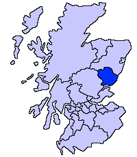
The council area of Angus covers 2,182 square kilometres (842 sq mi), and has a population of around 110,300. There are 95 Category A listed buildings in the area.
Listed buildings
| Name | Location | Date Listed | Grid Ref. [note 1] | Geo-coordinates | Notes | LB Number [note 2] | Image |
|---|---|---|---|---|---|---|---|
| Airlie Parish Kirk | Airlie | NO3132351526 | 56°39′02″N 3°07′18″W | 18th-century church[5] | 4621 |  | |
| Barry Mill | Barry | 11/11/2009 | NO5341134966 | 56°30′16″N 2°45′31″W | A water-powered, working meal mill [6] | 4649 |  |
| Careston Castle | Careston | NO5307459888 | 56°43′42″N 2°46′07″W | Late-16th-century tower house with later additions[7] | 4656 |  | |
| Bridge of Dun | Near House of Dun, over the River South Esk, Montrose | NO6627258424 | 56°42′59″N 2°33′09″W | Three-arch stone bridge, completed 1787 by Alexander Stevens[8] | 4677 |  | |
| House of Dun | Montrose | NO6704359881 | 56°43′46″N 2°32′25″W | Country house by William Adam, circa 1730[9] | 4691 |  | |
| House of Dun court of offices | Montrose | NO6698459872 | 56°43′46″N 2°32′28″W | By William Adam, circa 1730[10] | 4692 |  | |
| St. Vigeans Parish Kirk | St Vigeans, Arbroath | NO6384242912 | 56°34′36″N 2°35′25″W | 12th- and 15th-century church, restored in 1871 by Robert Rowand Anderson[11] | 4770 | 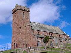 | |
| Melgund Castle | Aberlemno | NO5460956330 | 56°41′47″N 2°44′34″W | Later 16th-century tower house[12] | 4931 | 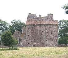 | |
| Usan House | Kirkton of Craig, Montrose | NO7221055227 | 56°41′17″N 2°27′19″W | Classical mansion of 1820[13] | 4964 |  | |
| Dunninald Castle | Kirkton of Craig, Montrose | NO7034354271 | 56°40′45″N 2°29′08″W | Tudor-Gothic castellated mansion by James Gillespie Graham, 1824[14] | 4972 | 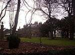 | |
| Kirk Tower House | Kirkton Of Craig, Montrose | NO7036955785 | 56°41′34″N 2°29′07″W | Former church built 1799, the earliest Gothic Revival church to be built in Scotland[15] | 4979 | .jpg) | |
| Craig House | Kirkton Of Craig, Montrose | NO7028556243 | 56°41′49″N 2°29′13″W | 17th-century L-plan house[16] | 4984 |  | |
| Craig House - Entrance Gateway | Kirkton Of Craig, Montrose | NO7033356217 | 56°41′48″N 2°29′10″W | 16th-century defensive gateway[17] | 4985 | | |
| Kintrockat House | Brechin | NO5684159131 | 56°43′19″N 2°42′25″W | Early-19th-century house[18] | 5011 | | |
| Ardovie House | Ardovie, Brechin | NO5931656483 | 56°41′54″N 2°39′57″W | 18th-century country house[19] | 5016 | | |
| Brechin Castle | Brechin | NO5978259892 | 56°43′44″N 2°39′32″W | Early-18th-century mansion with 19th-century remodelling[20] | 5030 |  | |
| Stannochy Bridge | Over the River South Esk near Brechin | NO5837259111 | 56°43′19″N 2°40′54″W | Single-arch stone bridge dated 1825, possibly by Robert Stevenson[21] | 5042 | 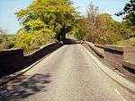 | |
| Auchterhouse Old Mansion House | Auchterhouse | NO3311337289 | 56°31′22″N 3°05′20″W | 17th-century mansion with 18th- and 19th-century additions, now a hotel[22] | 5689 |  | |
| Auchterhouse Old Mansion House, Dovecot | Auchterhouse | NO3321337345 | 56°31′24″N 3°05′14″W | 17th-century dovecote[23] | 5690 | | |
| Balruddery, East Gates | Balruddery House, Liff | NO3190531830 | 56°28′25″N 3°06′25″W | Gateway designed by David Neave in 1820 for Balruddery House, now demolished[24] | 10854 |  | |
| Gallery | Marykirk | NO6731965612 | 56°46′51″N 2°32′11″W | 17th- and 18th-century country house[25] | 11165 | | |
| Upper North Water Bridge | Over River North Esk near Marykirk | Delisted | NO6527166139 | 56°47′08″N 2°34′12″W | 16th-century three-arch stone bridge, rebuilt in the 19th century[26][note 3] | 11170 | 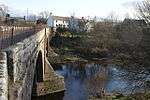 |
| Marykirk Bridge [note 3] | Over River North Esk at Marykirk | NO6859765008 | 56°46′32″N 2°30′56″W[note 3]) | Four-arch stone bridge by Robert Stevenson, 1814[27] | 11177 | | |
| Marykirk Bridge, Tollhouse | Marykirk | NO6854964977 | 56°46′31″N 2°30′58″W | Single-storey toll house by Robert Stevenson, 1814[28] | 11178 | | |
| Edzell Castle | Edzell | Delisted | NO5846169108 | 56°48′42″N 2°40′55″W | Remains of 16th-century castle with 17th-century additions and formal garden[29] | 11257 |  |
| Red Castle - Enceinte | Lunan | NO6878351079 | 56°39′02″N 2°30′39″W | 13th-century defensive wall[30] | 11273 |  | |
| Red Castle - Keep | Lunan | NO6878351079 | 56°39′02″N 2°30′39″W | Ruins of 15th-century tower house[31] | 11274 | 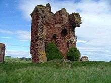 | |
| Ethie Castle | Inverkeilor | NO6873646844 | 56°36′45″N 2°30′39″W | 15th-century tower house with later additions, altered in 1892 by Robert Rowand Anderson[32] | 11278 |  | |
| Invermark Castle | Glen Mark | NO4422280394 | 56°54′41″N 2°55′03″W | Early-16th-century tower house with 17th-century additions[33] | 11349 |  | |
| Restenneth Priory | Forfar | Not listed | NO4822251600 | 56°39′12″N 2°50′46″W | Ruins of 13th-century Romanesque church and monastery[34] | 11386 | .jpg) |
| Baldovie Farmhouse | Kirkton of Kingoldrum | NO3243954073 | 56°40′25″N 3°06′15″W | Late-17th-century Renaissance mansion[35] | 11417 | | |
| Farnell Parish Kirk | Farnell | NO6273855425 | 56°41′21″N 2°36′36″W | Gothic Revival church of 1806[36] | 11497 | 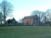 | |
| Farnell Castle | Farnell | NO6242955488 | 56°41′23″N 2°36′54″W | Medieval residence of the Bishops of Brechin, altered in the 16th century[37] | 11501 | | |
| Strathmore Aisle | Glamis | NO3864446855 | 56°36′34″N 3°00′04″W | 15th-century aisle of demolished church, later altered, with burial monuments of Lords of Glamis[38] | 11556 | | |
| Inverquharity Castle | Kirriemuir | NO4112057953 | 56°42′34″N 2°57′48″W | 15th-century tower house[39] | 11665 | 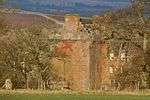 | |
| Mains of Rochelhill Dovecot | Charleston | NO3750245142 | 56°35′38″N 3°01′10″W | Lectern dovecote dated 1713[40] | 11670 | 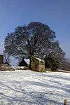 | |
| Glamis Castle | Glamis | NO3858648054 | 56°37′13″N 3°00′09″W | 15th-century tower house with 17th-, 18th- and 19th-century ranges, seat of the Earl of Strathmore and Kinghorne[41] | 11701 | 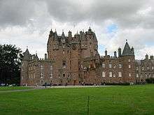 | |
| Glamis Castle sundial | Glamis | NO3863647990 | 56°37′11″N 3°00′06″W | Later 17th-century faceted sundial[42] | 11705 |  | |
| Glamis Castle dovecot | Glamis | NO3840747286 | 56°36′48″N 3°00′18″W | Earlier 17th-century lectern dovecot[43] | 11710 |  | |
| Pitmuies Home Farm | Guthrie | NO5671149836 | 56°38′18″N 2°42′27″W | Late-18th-century farmstead with horse mill[44] | 11875 | | |
| Gardyne Castle | Friockheim | NO5736948790 | 56°37′44″N 2°41′47″W | 16th-century L-plan tower house with later additions[45] | 11914 |  | |
| Braikie Castle | Friockheim | NO6284650893 | 56°38′54″N 2°36′27″W | Remains of 16th-century L-plan tower house[46] | 12325 | 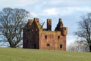 | |
| Mains of Edzell Doocot | Edzell | NO5886869079 | 56°48′41″N 2°40′31″W | Turreted dovecote of circa 1600[47] | 12385 |  | |
| Pitmuies House | Guthrie | NO5672049762 | 56°38′16″N 2°42′26″W | Later 18th-century mansion[48] | 13076 | 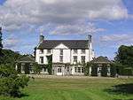 | |
| Lundie Parish Church | Lundie | NO2906236610 | 56°30′58″N 3°09′16″W | Medieval Romanesque church, rebuilt 19th century, and Duncan family mausoleum by Robert Mylne[49] | 13090 | 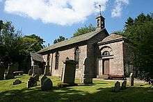 | |
| Fowlis Easter Parish Church | Fowlis, Liff | NO3221033455 | 56°29′18″N 3°06′09″W | 15th-century church[50] | 13144 | 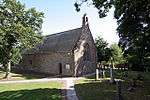 | |
| Balintore Castle | 10 kilometres (6.2 mi) north-west of Kirriemuir | NO2902859015 | 56°43′03″N 3°09′40″W | Derelict Baronial mansion, 1860 by William Burn[51] | 13757 |  | |
| Tealing Parish Church | Tealing | NO4035037943 | 56°31′47″N 2°58′17″W | Early-19th-century former church, incorporating several sculpted stones within its walls[52] | 17450 | 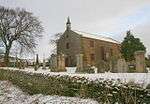 | |
| South Balluderon Farm | Tealing | NO3755438078 | 56°31′50″N 3°01′00″W | Unaltered farm buildings and mill dating to circa 1800[53] | 17458 | | |
| Affleck Castle | Monikie | NO4940238808 | 56°32′19″N 2°49′28″W | 15th-century tower house[54] | 17609 | .jpg) | |
| Pitscandly House | Forfar | NO4842752537 | 56°39′42″N 2°50′35″W | Late-17th-century mansion[55] | 17657 | | |
| Balnamoon House sundial | Balnamoon House, near Brechin | NO5514663689 | 56°45′45″N 2°44′07″W | Lectern sundial circa 1700[56] | 17700 | | |
| House of Kinnaber | Montrose | NO7256061751 | 56°44′48″N 2°27′01″W | L-plan mansion dated 1680[57] | 17762 |  | |
| Stracathro House | Stracathro | NO6257265561 | 56°46′48″N 2°36′51″W | Graeco-Roman mansion by Archibald Simpson, 1827[58] | 17803 | 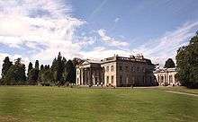 | |
| Stracathro House stables | Stracathro | NO6237065575 | 56°46′49″N 2°37′03″W | Stable block by Archibald Simpson, 1827[59] | 17804 | | |
| Downie Park House | Kirriemuir | NO4086458572 | 56°42′54″N 2°58′04″W | Country house circa 1805[60] | 18034 | | |
| Panmure Estate - The West Gate | Craigton | NO5309038445 | 56°32′08″N 2°45′52″W | Renaissance-style gateway by Sir William Bruce, circa 1672 [61] | 18418 | | |
| Panmure Estate, Commemorative Column | Craigton | NO5375538956 | 56°32′25″N 2°45′13″W | 50-foot (15 m) Renaissance column, commemorating the 1694 marriage of James Maule, 4th Earl of Panmure [62] | 18419 | .jpg) | |
| Tealing House Dovecot | Tealing | Delisted | NO4128338134 | 56°31′54″N 2°57′22″W | 16th-century gabled dovecote[63] | 18988 | 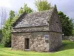 |
| Gagie House | Murroes | NO4492837583 | 56°31′37″N 2°53′49″W | Early-17th-century fortified house with later additions[64] | 19001 | | |
| Gagie House, summerhouse | Murroes | NO4494037564 | 56°31′37″N 2°53′48″W | 18th-century Renaissance-style summer house[65] | 19004 | | |
| Murroes House | Murroes | NO4611735034 | 56°30′15″N 2°52′37″W | 16th-century tower house with 17th-century range, restored 1942[66] | 19011 | | |
| Arbroath Abbey - Abbey Church And Precincts | Arbroath | NO6431141334 | 56°33′45″N 2°34′56″W | Ruins of church founded in 1176 by William the Lion[67] | 21130 |  | |
| Arbroath Abbey - Conventual Building | Arbroath | NO6427741297 | 56°33′44″N 2°34′58″W | Ruins of 13th-century west range[68] | 21131 |  | |
| Arbroath Abbey - Pend | Arbroath | NO6423641299 | 56°33′44″N 2°35′01″W | 15th-century fortified gatehouse[69] | 21132 |  | |
| Arbroath Abbey - Regality Tower | Arbroath | NO6421041286 | 56°33′44″N 2°35′02″W | 13th-century keep[70] | 21133 | | |
| Arbroath Abbey - Abbot's House | Arbroath | NO6427641275 | 56°33′43″N 2°34′58″W | Partly 13th-century, the best surviving example of its type in Scotland[71] | 21134 |  | |
| Baltic Works | Arbroath, Dens Road | NO6394741474 | 56°33′50″N 2°35′18″W | 1852 linen factory, later a bonded warehouse[72] | 21141 |  | |
| Bell Rock Lighthouse Signal Tower and Entrance Lodges | Arbroath, Lady Loan | NO6405140447 | 56°33′17″N 2°35′11″W | Classical lodges and signal tower, built 1813 to communicate with the Bell Rock Lighthouse[73] | 21230 |  | |
| The Elms | Arbroath, Cairnie Road | NO6320541750 | 56°33′59″N 2°36′01″W | French Gothic mansion by William Leiper, 1869[74] | 21250 | | |
| Mortuary Chapel - Western Cemetery | Arbroath | NO6248041770 | 56°33′59″N 2°36′44″W | Baronial chapel, built 1875 by Patrick Allan-Fraser[75] | 21252 |  | |
| Hospitalfield | Arbroath | NO6258340431 | 56°33′16″N 2°36′37″W | Mid 19th-century Baronial mansion by Patrick Allan-Fraser[76] | 21253 |  | |
| Brechin Cathedral | Brechin | NO5962560091 | 56°43′51″N 2°39′41″W | 12th-century onwards, restored circa 1900 by John Honeyman[77] | 22439 |  | |
| Round Tower at south west angle of Cathedral Church Lane | Brechin | NO5962560091 | 56°43′51″N 2°39′41″W | 11th-century round tower, 101 feet (31 m) high[78] | 22440 |  | |
| 25, 27 High Street | Brechin | NO5972960189 | 56°43′54″N 2°39′35″W | 18th-century town houses with shops below[79] | 22476 | | |
| 68-74 High Street | Brechin | NO5977160095 | 56°43′51″N 2°39′33″W | 17th-century or earlier town houses with shops below[80] | 22505 | | |
| Maison Dieu Chapel | Brechin | NO5966660340 | 56°43′59″N 2°39′39″W | Remains of 13th-century chapel[81] | 22508 | 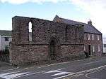 | |
| Baptist Church and Halls | Brechin, Panmure Street | NO5986660416 | 56°44′01″N 2°39′27″W | 19th-century church and hall, formerly West and St Columba's Parish Church[82] | 22522 | 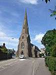 | |
| Brechin Bridge | Brechin, over River South Esk | NO6044159263 | 56°43′24″N 2°38′53″W | Partly 13th-century, rebuilt in the 18th century[83] | 22549 |  | |
| Southesk Church (Former Gardner Memorial Church) | Brechin | NO6006160166 | 56°43′53″N 2°39′16″W | Mixed Romanesque and late Gothic, 1900 by John James Burnet[84] | 22568 | 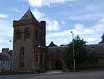 | |
| Municipal Buildings | Forfar, Castle Street | NO4560850663 | 56°38′41″N 2°53′19″W | Built 1824 as Sheriff Court, by David Neave[85] | 31542 | 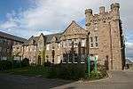 | |
| Lowson Memorial Parish Church | Forfar | NO4649250881 | 56°38′48″N 2°52′27″W | Scots Gothic church, 1914 by Alexander Marshall Mackenzie[86] | 31604 |  | |
| St. Mary's Episcopal Church | Kirriemuir | NO3832654375 | 56°40′37″N 3°00′29″W | Gothic revival church, 1905 by Ninian Comper[87] | 36899 | | |
| 174 High Street (Holly House) | Montrose | NO7140457765 | 56°42′39″N 2°28′07″W | 17th- and 18th-century town house[88] | 38041 | | |
| 190 High Street, The Retreat | Montrose | NO7139557733 | 56°42′37″N 2°28′08″W | Early-18th-century town house[89] | 38046 | | |
| 214 and 216 High Street, Public Library | Montrose | NO7137057674 | 56°42′36″N 2°28′09″W | Carnegie Library, built 1905 in Baronial style by J. Lindsay Grant[90] | 38051 |  | |
| Montrose Town House | Montrose, High Street | NO7145257791 | 56°42′39″N 2°28′05″W | 18th-century municipal buildings[91] | 38083 | 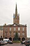 | |
| Montrose Parish Church | Montrose, High Street | NO7146557756 | 56°42′38″N 2°28′04″W | Late-18th-century church, with 19th-century spire by James Gillespie Graham[92] | 38084 | 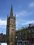 | |
| 10 Castle Place, Straton House | Montrose | NO7142157602 | 56°42′33″N 2°28′06″W | 18th-century town house[93] | 38095 | | |
| Montrose Infirmary | Montrose | NO7104457439 | 56°42′28″N 2°28′28″W | 19th-century hospital building by James Collie[94] | 38112 | 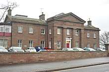 | |
| 1-8 (inclusive nos) Panmure Terrace | Montrose | NO7165257787 | 56°42′39″N 2°27′53″W | Mid 19th-century Classical terrace of eight houses[95] | 38195 | 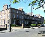 | |
| St Mary's and St Peter's Episcopal Church | Montrose | NO7172957772 | 56°42′39″N 2°27′48″W | Mid 19th-century Gothic Revival church by John Henderson[96] | 38204 | 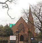 | |
| Chapel Works | Montrose | NO7187157735 | 56°42′38″N 2°27′40″W | Textile mills, 1833 with later additions, the largest mills in Angus outside Dundee[97] | 38212 | .jpg) | |
| Montrose Air Station Building 48 | Montrose Airfield | NO7179559399 | 56°43′31″N 2°27′45″W | Unaltered military aircraft shed built 1914[98] | 38228 | 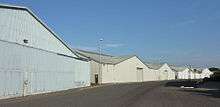 | |
| Bell Rock Lighthouse | Inchcape, offshore from Arbroath | NO7616526808 | 56°25′58″N 2°23′17″W | Lighthouse built 1811 by Robert Stevenson[99] | 45197 | 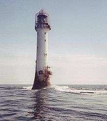 | |
| Logie Schoolhouse, Former U.F. Church | Logie | NO6980863554 | 56°45′45″N 2°29′44″W | Later-18th- or early-19th-century vernacular school house, later used as a church[100] | 50209 | |
See also
Notes
- Sometimes known as OSGB36, the grid reference (where provided) is based on the British national grid reference system used by the Ordnance Survey.
• "Guide to National Grid". Ordnance Survey. Retrieved 2007-12-12.
• "Get-a-map". Ordnance Survey. Retrieved 2007-12-17. - Historic Environment Scotland assign a unique alphanumeric identifier to each designated site in Scotland, for listed buildings this always begins with "LB", for example "LB12345".
- Also in Aberdeenshire, as it crosses the River North Esk which is the council boundary
References
- Guide to the Protection of Scotland’s Listed Buildings (PDF). Historic Scotland. 2009. p. 4. ISBN 978-1-84917-013-0. Retrieved 2010-05-05.
- "What is Listing?". Historic Scotland. Retrieved 2010-05-05.
- Scottish Historic Environment Policy (PDF). Historic Scotland. October 2008. pp. 24–25. ISBN 978-1-84917-002-4. Retrieved 2010-05-05.
- Guide to the Protection of Scotland’s Listed Buildings, p. 17.
- "Airlie Parish Kirk: Listed Building Report". Historic Scotland.
- "BARRY MILL INCLUDING MILLER'S COTTAGELB4649". Historic Environment Scotland. Retrieved 29 August 2017.
- "Careston Castle: Listed Building Report". Historic Scotland.
- "Bridge Of Dun: Listed Building Report". Historic Scotland.
- "House Of Dun (Hotel): Listed Building Report". Historic Scotland.
- "House Of Dun Court Of Offices: Listed Building Report". Historic Scotland.
- "St. Vigeans Parish Kirk: Listed Building Report". Historic Scotland.
- "Melgund Castle: Listed Building Report". Historic Scotland.
- "Usan House: Listed Building Report". Historic Scotland.
- "Dunninald Castle: Listed Building Report". Historic Scotland.
- "Kirkton Of Craig, Kirk Tower House: Listed Building Report". Historic Scotland.
- "Craig House: Listed Building Report". Historic Scotland.
- "Craig House - Entrance Gateway: Listed Building Report". Historic Scotland.
- "Kintrockat House: Listed Building Report". Historic Scotland.
- "Ardovie House: Listed Building Report". Historic Scotland.
- "Brechin Castle: Listed Building Report". Historic Scotland.
- "Stannochy Bridge: Listed Building Report". Historic Scotland.
- "Auchterhouse Old Mansion House Hotel Including Game Store Garden And Enclosing Walls: Listed Building Report". Historic Scotland.
- "Auchterhouse Old Mansion House Hotel Dovecot: Listed Building Report". Historic Scotland.
- "Balruddery, East Gates, Including Gatepiers, Quadrants And Adjoining Walls: Listed Building Report". Historic Scotland.
- "Gallery: Listed Building Report". Historic Scotland.
- "Upper North Water Bridge: Listed Building Report". Historic Scotland.
- "Marykirk Bridge: Listed Building Report". Historic Scotland.
- "Marykirk Bridge, Tollhouse.: Listed Building Report". Historic Scotland.
- "Edzell Castle: Listed Building Report". Historic Scotland.
- "Red Castle - Enceinte: Listed Building Report". Historic Scotland.
- "Red Castle - Keep.: Listed Building Report". Historic Scotland.
- "Ethie Castle: Listed Building Report". Historic Scotland.
- "Invermark Castle: Listed Building Report". Historic Scotland.
- "Restenneth Priory: Listed Building Report". Historic Scotland.
- "Baldovie Farmhouse: Listed Building Report". Historic Scotland.
- "Farnell Parish Kirk: Listed Building Report". Historic Scotland.
- "Farnell Castle: Listed Building Report". Historic Scotland.
- "Glamis Village, Kirkwynd, Parish Kirk, Strathmore Aisle: Listed Building Report". Historic Scotland.
- "Inverquharity Castle: Listed Building Report". Historic Scotland.
- "Mains Of Rochelhill Dovecot: Listed Building Report". Historic Scotland.
- "Glamis Castle: Listed Building Report". Historic Scotland.
- "Glamis Castle Policies, Sundial: Listed Building Report". Historic Scotland.
- "Glamis Castle Policies, Dovecot: Listed Building Report". Historic Scotland.
- "Pitmuies - Home Farm.: Listed Building Report". Historic Scotland.
- "Gardyne Castle: Listed Building Report". Historic Scotland.
- "Braikie Castle: Listed Building Report". Historic Scotland.
- "Edzell Castle, Mains Of Edzell, Doocot: Listed Building Report". Historic Scotland.
- "Pitmuies House: Listed Building Report". Historic Scotland.
- "Parish Church, Including Duncan Burial Enclosure, Churchyard Wall And Gatepiers: Listed Building Report". Historic Scotland.
- "Fowlis Easter Parish Church Including Churchyard Cross And Graveslab And Boundary Wall: Listed Building Report". Historic Scotland.
- "Balintore Castle: Listed Building Report". Historic Scotland.
- "Kirkton Of Tealing, Former Tealing Parish Church, Including Churchyard: Listed Building Report". Historic Scotland.
- "South Balluderon Farm, Steading Including Stackyard Walls, Implement Shed, Field Trough And Mill Dam With Walls: Listed Building Report". Historic Scotland.
- "Affleck Castle: Listed Building Report". Historic Scotland.
- "Pitscandly House: Listed Building Report". Historic Scotland.
- "Balnamoon House - Lectern-Type Sundial E. Of House: Listed Building Report". Historic Scotland.
- "House Of Kinnaber: Listed Building Report". Historic Scotland.
- "Stracathro House (Staff Residence Of Stracathro Hospital): Listed Building Report". Historic Scotland.
- "Stracathro House Stables: Listed Building Report". Historic Scotland.
- "Downie Park House: Listed Building Report". Historic Scotland.
- "Panmure Estate - The West Gate: Listed Building Report". Historic Scotland.
- "Panmure Estate - Commemorative Column.: Listed Building Report". Historic Scotland.
- "Tealing House, Tealing Home Farm, Dovecot: Listed Building Report". Historic Scotland.
- "Gagie, Gagie House: Listed Building Report". Historic Scotland.
- "Gagie, Gagie House, Summerhouse: Listed Building Report". Historic Scotland.
- "Murroes, Murroes House, Including Boundary Wall And Out Buildings: Listed Building Report". Historic Scotland.
- "Arbroath Abbey - Abbey Church And Precincts: Listed Building Report". Historic Scotland.
- "Arbroath Abbey - Conventual Building: Listed Building Report". Historic Scotland.
- "Arbroath Abbey - Pend: Listed Building Report". Historic Scotland.
- "Arbroath Abbey - Regality Tower: Listed Building Report". Historic Scotland.
- "Arbroath Abbey - Abbot's House: Listed Building Report". Historic Scotland.
- "Dens Road, Baltic Works (Former Arbroath Warehouse Limited Bond Number 1): Listed Building Report". Historic Scotland.
- "Ladyloan, Bell Rock Lighthouse Signal Tower And Entrance Lodges: Listed Building Report". Historic Scotland.
- "The Elms: Listed Building Report". Historic Scotland.
- "Mortuary Chapel - Western Cemetery: Listed Building Report". Historic Scotland.
- "Hospital Field: Listed Building Report". Historic Scotland.
- "Brechin Cathedral Church Lane.: Listed Building Report". Historic Scotland.
- "Round Tower At South West Angle Of Cathedral Church Lane: Listed Building Report". Historic Scotland.
- "25, 27 High Street: Listed Building Report". Historic Scotland.
- "68-74 High Street: Listed Building Report". Historic Scotland.
- "Maison Dieu Chapel Maisondieu Lane: Listed Building Report". Historic Scotland.
- "Baptist Church (Formerly West And St Columba's Parish Church) And Halls, Panmure Street/Southesk Street: Listed Building Report". Historic Scotland.
- "Brechin Bridge Over River South Esk Off River Street.: Listed Building Report". Historic Scotland.
- "Southesk Church (Former Gardner Memorial Church) St Ninian's Square And Damacre Road Including Church Halls And Vestries.: Listed Building Report". Historic Scotland.
- "Municipal Buildings Castle Street: Listed Building Report". Historic Scotland.
- "Lowson Memorial Parish Church Jamieson Street: Listed Building Report". Historic Scotland.
- "St. Mary's Episcopal Church, West Hillbank: Listed Building Report". Historic Scotland.
- "174 High Street (Holly House) Including Boundary Walls: Listed Building Report". Historic Scotland.
- "190 High Street, The Retreat, Including Boundary Walls: Listed Building Report". Historic Scotland.
- "214 And 216 High Street, Public Library Including Boundary Walls: Listed Building Report". Historic Scotland.
- "High Street, Town House: Listed Building Report". Historic Scotland.
- "High Street, Montrose Parish Church (Church Of Scotland), Including Churchyard, Boundary Walls And Gatepiers: Listed Building Report". Historic Scotland.
- "10 Castle Place, Straton House Including Boundary Walls: Listed Building Report". Historic Scotland.
- "Bridge Street, Montrose Infirmary, Including Ancillary Structures To North, And Boundary Walls And Gatepiers To Bridge Street: Listed Building Report". Historic Scotland.
- "1-8 (Inclusive Nos) Panmure Terrace Including Boundary Walls: Listed Building Report". Historic Scotland.
- "Provost Scott's Road, St Mary's And St Peter's Episcopal Church Including Churchyard, Boundary Walls, Gatepiers And Gates.: Listed Building Report". Historic Scotland.
- "Eastern Road And Paton's Lane, Chapel Works Or Bond (Centre Buildings) To Paton's Lane: Listed Building Report". Historic Scotland.
- "Montrose Air Station Building 48: Listed Building Report". Historic Scotland.
- "Bell Rock Lighthouse: Listed Building Report". Historic Scotland.
- "Logie Schoolhouse, Former U.F. Church: Listed Building Report". Historic Scotland.
External links
![]()