Linkinhorne
Linkinhorne (in Cornish Lanngynhorn) is a civil parish and village in southeast Cornwall, England, United Kingdom. The village itself is situated at grid reference SX 320 736 and is approximately four miles (6.5 km) northwest of Callington and seven miles (11 km) south of Launceston.[1] The parish population at the 2011 census including Downgate was 1,541[2]

.jpg)
Geography
As well as Linkinhorne itself, other settlements in the parish include (in alphabetical order) Bray Shop, Caradon Town, Downgate, Henwood, Ley Mill, Minions, Plushabridge, Rilla Mill and Upton Cross.[1] The area is bordered by the River Inny in the north-east and Bodmin Moor to the west. The valley of the River Lynher runs through the parish.[1]

History
Linkinhorne parish is within the Deanery and Hundred of East and is bounded on the north by North Hill and Lezant, on the east by Stoke Climsland and South Hill, on the south and west by St Ive and St Cleer. The name Linkinhorne means church site (Lann) of Kenhoarn. In the Domesday Book of 1086, the manor is referred to as Resleston (town by the ford) (Rillaton).[4]
The parish is largely rural but west of the B3254 road from Launceston to Liskeard, the parish includes part of Caradon Hill, once an industrialised mining area.
The parish church of St Melor is built of granite and dates from the 15th century. The tower is 120 ft high and the interesting features of the church include a medieval altar slab, the 13th-century font and 15th-century wall paintings. The north aisle and lofty tower are said to have been built at the expense of Henry Trecarrel.[5] Daniel Gumb (d. 1776), a stonemason, lived in a cottage near the Cheesewring; several gravestones in Linkinhorne churchyard were carved by him.[6]
In medieval times there were chapels at Trefrize and Caradon.[7] Arthur Langdon (1896) records a Cornish cross and a cross base at North Coombe; and another cross base at Sturt's Corner.[8] Andrew Langdon (1996) records the cross at Northcoombe (it was set up on a stone in 1908).[9]
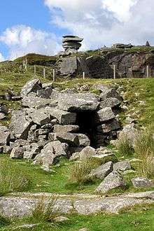
Also in the parish are the Holy Well of St Melor; a 15th-century bridge over the Lynher at Plushabridge; and near Minions the Rillaton round barrow (in which Bronze Age grave goods, including a gold beaker, were discovered in 1837). The Hurlers are a group of three stone circles near Upton Cross.
The manor of Rillaton was the head manor of the Hundred of East and one of the 17 Antiqua maneria of the Duchy of Cornwall.
Notable people
- The wrestler James Gerry (born circa 1858) fought Samuel Rundle (Plymouth) for the championship of Cornwall in 1883. Lasting just over an hour, the match ended in a draw in the 19th round following Rundle tearing leg muscles. Gerry was reported in The Cornishman newspaper to have vanquished all the best men in America as well as many men in Cornwall.[10]
References
- Ordnance Survey: Landranger map sheet 201 Plymouth & Launceston ISBN 978-0-319-23146-3
- "Parish population census 2011". Retrieved 9 February 2015.
- Wheal Phoenix mine information at Mindat.org
- GENUKI website; Linkinhorne; retrieved April 2010
- Cornish Church Guide Truro: Blackford(1925); pp. 144-45
- Pevsner, N. (1970) Cornwall; 2nd ed., rev. by Enid Radcliffe. Penguin; p. 109
- The Cornish Church Guide (1925); p. 145
- Langdon, A. G. (1896) Old Cornish Crosses. Truro: Joseph Pollard; pp. 89 & 423
- Langdon, A. G. (2005) Stone Crosses in East Cornwall; 2nd ed. Federation of Old Cornwall Societies; pp. 45-46
- "The Wrestling Championship Of Cornwall". The Cornishman (258). 21 June 1883. p. 6.
External links
| Wikimedia Commons has media related to Linkinhorne. |
Cornwall Portal | |
| Unitary authorities | |
| Major settlements |
|
| Rivers | |
| Topics | |