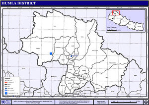
Limi
Limi is a valley in Humla District in the Karnali Zone of north-western Nepal. The whole valley comprises the Ward no.6 of Namkha Rural Municipality in the present federal set up of Nepal. Previously the whole valley was known as the Limi Village Development Committee (VDC). As of the 1991 Nepal census, it had a population of 988 persons living in 169 individual households.[1]
Limi Valley लिमी | |
|---|---|
Ward | |
 | |
| Nickname(s): Hidden Valley | |
 Limi Valley Location in Nepal | |
| Coordinates: 30.29°N 81.65°E | |
| Country | |
| Province | Karnali Province |
| District | Humla District |
| Rural Municipality | Namkha Rural Municipality |
| Ward | Ward No.6 |
| Population (2010) | |
| • Total | 1,000+ |
| • Religions | Tibetan Buddhism |
| Time zone | UTC+5:45 (Nepal Time) |
| Website | lmihumla |
Geography and climate
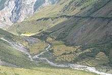
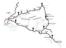
Limi is a remote Trans-Himalayan Valley in north-west Nepal bordering Tibet. It consists of three villages: Til (4100 m elevation) in the west; Jhang (3930 m) in the east; and the biggest village, Halji (3700 m), in the middle. These three villages are situated on the banks of the Karnali river.
Limi has a cold semi-arid climate according to the Köppen-Geiger climate classification. Summers are short and rainfall very sparse. Winter is marked with regular snowfall.
Language and speech
Although Nepal's national language is Nepali but for Limi people Nepali is second language. Very few of villagers can speak good Nepali. That is because of people speak only Tibetan in daily basis and only few moment like documents work in government office and business with other. Tibetan language speak in Limi is seeming quite different. So, They and some other communities call this language "Limi Kye"; which means Limi language, but actually that language is same Tibetan. Tibetan language has so many dilation and They speak Tibetan with accent based on Central Tibetan. According to Nepal Trust NGO's research said Limi's Tibetan is much closer and cleaner than other Himalayan communities to central Tibetan.
Story
Limi is named after people living in there. The name is Tibetan word. "གླེ་" (pronounce like "Le") means land between two rivers in Tibetan. and "མི་" (pronounce like "Mi") means people. "གླེ་མི་"(Le-Mi) means people living or situated on land between two rivers. Later on some kind of mispronounced and written like Limi.
According to legends, Long time ago many Tibetan come to do business between Nepal and Tibet border and some Tibetan traders settled in Limi because of its strategic location. Since they settled in between two rivers; they are called "Le-Mi".
Traditionally and culturally, Limis have strong ties to the Tibetans.
There is a long tradition of trade and cultural exchange between this part of Nepal and Tibet. Due to its remoteness to other parts of Nepal and district headquarter Simikot, people living in Limi still rely on trade with Tibet.
Limi Villages
There are three villages in Limi - Til, Halji and Zang. Til is closest village of Limi towards the main border point of Hilsa. Halji located in the middle of limi. And Jhang meets other side border to Burang, Tibet.
Til
Situated approximately at an altitude of 4,100 meters (13,500 ft), surrounded by barley fields and at western side of Limi Valley, is a Til Village. Til is name derived from a hill of Til village; where villagers used to live there before. People are called "Til-Wa".
Entrance to the village is a small wooden bridge, after which the path passes through a two-footed Stupa. At the right side of village, an easily falling water which provides the water supply as it going down of the village. The houses are well constructed from dry stone and conversing with neighbors. A Large Prayer Wheel house and telephone room at 1st floor is located at the center of the village. Tila or Til village is most least population village of Limi villages, of around 30 families living in there. More than 300 years aged monastery called Kunzum Do-Nag Choeden Monastery is situated right crossing easy falling water.
Zang
Zang situated at altitude of 3930 meters from the sea level. And it is easternmost and well situated village according to geographical than two other villages. The village is neatly arranged in two clusters separated by fields and the main public road along the valley. Around 250 years age of Gompa (Monastery) is prominently located above the village. It has almost 100 families population. There is not much agricultural land around village but huge hinterland of Yak, Sheep & Goat grazing areas located in the deep gorge of upper Limi valley to the north and east side of this village. Nomadic settlements are temporary put up for herders during season on those grazing lands. It touches other side of border to Tibet, China. And That makes them more easy to transport than other two. It is set alongside and facing the river (one of the tributaries of River Karnali) on the gently sloping north side of the valley amidst terraced barley fields.
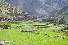
Halji
Halji village is situated about 3750 meters from the sea level and located between Tila and Jhang. it is the biggest village in Limi Valley with about 130 households. The central focus of the village is the more than 800 ages old historical Gompa (Monastery) where many religious festivals and rituals are performed. It is the monastic headquarter of Limi Valley. Name of village is also derived from a hill ancestors used to live. And then shift to present area due to safety from nature disaster. like Til Village, buildings are of dry-stone construction with more inter-linking flat roofs than Til; providing easy communication between neighbours.
Social structure
Limi is a close knitted society with high regard for the family. Though there is no class structure, two distinct groups can be found on the basis of family size and ancestry. Limi people still follow their ancient way of life that has remained unhindered despite political turmoils and changes that have occurred in rest of the country.
Religion
Limis follow the Drikung kagyu sect of Tibetan Buddhism, which is among the influential among the lesser 8 sects within the Kagyupa Sect. The Spiritual heads of the Drikung Kagyu Sect are the two Drikung Kyabgons Chetsang Rinpoche and Chungtsang Rinpoche. The 3 limi monasteries are headed by Trulku Senge Tenzin Rinpoche.
Source of living
For many centuries Agriculture and animal husbandry has been the primary source of living in Limi. Recently Trade and commerce have also been playing a vital role. Limi's proximity to china has been of immense help to local businesses. Many small scale enterprises have also sprung up. Another major economic activity for limis had been the production of wooden bowl. These wooden bowls prepared in limi are circulated throughout Tibet from the border town of Burang. Limi's high altitude and harsh climate poses many difficulties for agriculture. Farming is only possible in the months from April to October. Small scale Terrace farming is widely practiced with only enough output for self-consumption. traditional farming practices are followed and the use of machines and chemical fertilizers are non-existential. Yak and zo manure is used. Barley, green peas, radish and cabbage are grown. Animal husbandry is a part of life in Limi. all of the grasslands are far from the villages as most of the land in and around the village is used for farming. The Limi people rely heavily on animals for everyday needs. Yak, zo, horses, sheep and goats are raised. These animals are herded to various grasslands depending on the season. Yak is the most useful of these animals its milk and meat is used for nourishment; its fur is used to make threads, tents, ropes, sacks, clothes, quilts and rugs; its hide is used to make bags, drums and shoes; it also is an excellent beast of burden. Yak is also in demand for its meat in and is regularly sold for high prices. Historically the men of Limi have always been traders, this can be partly attributed to the fact that basic commodities like salt and flour could not be locally obtained. Cross border trade with Tibet has been prevalent for centuries. Barter trade was the norm of the day and wool was sent from Limi in exchange for salt. This salt was then traded in Humla. Today much of the face of the trade has changed. An average Limi trader fares much better than his predecessors, in that the scope and magnitude of the business has increased. Wooden handicrafts like bowls and traditional tables are sent to Tibet in exchange for essential food items.
People in the valley are sustained by simple agriculture and traditional way of trading across the border of wooden handicrafts and hand made goods.
Tourist factors
Due to its remoteness, There are so many things which recall some age ago Tibet's Condition. People in there are still following old way of system. It is also a popular destination for high altitude hiking trails.
Limi Valley trekking trail firstly introduced in 2002 among foreigners. Stunning valley and ancient Tibetan culture is the most fascinating of the trail. Marmots, wolves, wild yaks, blue sheep, wild horses, barking deer, musk deer, Himalayan black bears and the elusive snow leopard can be seen. Villages at shoulder of hills offer a chance to explore the hidden chapter of Limi Valley. Entering Limi Valley is like stepping back in time. Even sightseeing of an 11th-century Gompa and century old Buddhist traditions interwoven with shamanistic influences are still an important part of daily life here are real witness of history is key point why to step in Limi Valley.
Major attractions
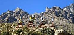
Halji Rinchenling Monastery
Built by the famous Translator Lotsawa Rinchen Zangpo, the Halji Rinchenling Monastery serves as the Spiritual Headquarter of the Trulku Senge Tenzin Rinpoche now. The monastery belongs to the Drikung Kagyu School of Tibetan buddhism just like all the Monasteries in Limi Valley. The monastery boast of artefacts and tradition that has been passed down since the time of Lotsawa Rinchen Zangpo himself. It is said that of the 108 Monasteries and Stupas he built across the Entire Himalayan Region, the Halji Rinchenling Monastery Stands at 108th. Recently, this monastery has been in danger of destruction due to effects of climate change. A Glacial Lake situated up on a cliff overlooking the Halji Village has threatened the very survival of the Village and the Monastery itself.
=
References
- "Nepal Census 2001". Nepal's Village Development Committees. Digital Himalaya. Archived from the original on 12 October 2008. Retrieved 4 September 2008.
External links
Headquarters: Simikot | ||
| Rural municipalities: | 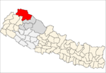 | |
List of municipalities and rural municipalities of Nepal | ||