Leipsic, Ohio
Leipsic /ˈlɪpsɪk/ is a village in Putnam County, Ohio, United States. The population was 2,093 at the 2010 census.
Leipsic, Ohio | |
|---|---|
 | |
| Motto(s): "Seeds of Growth Are Sown Here" | |
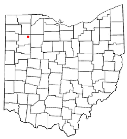 Location of Leipsic, Ohio | |
| Coordinates: 41°6′6″N 83°59′3″W | |
| Country | United States |
| State | Ohio |
| County | Putnam |
| Area | |
| • Total | 3.66 sq mi (9.48 km2) |
| • Land | 3.65 sq mi (9.45 km2) |
| • Water | 0.01 sq mi (0.03 km2) |
| Elevation | 764 ft (233 m) |
| Population | |
| • Total | 2,093 |
| • Estimate (2019[4]) | 2,022 |
| • Density | 573.4/sq mi (221.4/km2) |
| Time zone | UTC-5 (Eastern (EST)) |
| • Summer (DST) | UTC-4 (EDT) |
| ZIP codes | 45815, 45856 |
| Area code(s) | 419 |
| FIPS code | 39-42602[5] |
| GNIS feature ID | 1064984[2] |
| Website | http://www.villageofleipsic.com/ |
History
Leipsic was platted in 1857.[6] The name is a variant spelling of Leipzig, one of the largest cities in eastern Germany.[7]
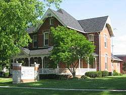
Two buildings in Leipsic are listed on the National Register of Historic Places: the old village hall and the John Edwards House.[8]
Geography
Leipsic is located at 41°6′6″N 83°59′3″W (41.101532, -83.984298).[9]
According to the United States Census Bureau, the village has a total area of 3.66 square miles (9.48 km2), of which 3.65 square miles (9.45 km2) is land and 0.01 square miles (0.03 km2) is water.[1]
Demographics
| Historical population | |||
|---|---|---|---|
| Census | Pop. | %± | |
| 1880 | 681 | — | |
| 1890 | 1,353 | 98.7% | |
| 1900 | 1,726 | 27.6% | |
| 1910 | 1,773 | 2.7% | |
| 1920 | 1,788 | 0.8% | |
| 1930 | 1,571 | −12.1% | |
| 1940 | 1,525 | −2.9% | |
| 1950 | 1,706 | 11.9% | |
| 1960 | 1,802 | 5.6% | |
| 1970 | 2,072 | 15.0% | |
| 1980 | 2,171 | 4.8% | |
| 1990 | 2,203 | 1.5% | |
| 2000 | 2,236 | 1.5% | |
| 2010 | 2,093 | −6.4% | |
| Est. 2019 | 2,022 | [4] | −3.4% |
| U.S. Decennial Census[10] | |||
2010 census
As of the census[3] of 2010, there were 2,093 people, 801 households, and 513 families living in the village. The population density was 573.4 inhabitants per square mile (221.4/km2). There were 905 housing units at an average density of 247.9 per square mile (95.7/km2). The racial makeup of the village was 77.8% White, 0.2% African American, 0.6% Native American, 0.4% Asian, 18.1% from other races, and 2.9% from two or more races. Hispanic or Latino of any race were 31.3% of the population.
There were 801 households of which 34.6% had children under the age of 18 living with them, 44.7% were married couples living together, 14.1% had a female householder with no husband present, 5.2% had a male householder with no wife present, and 36.0% were non-families. 31.6% of all households were made up of individuals and 17.4% had someone living alone who was 65 years of age or older. The average household size was 2.58 and the average family size was 3.25.
The median age in the village was 37 years. 27.9% of residents were under the age of 18; 8.1% were between the ages of 18 and 24; 24% were from 25 to 44; 23.8% were from 45 to 64; and 16.1% were 65 years of age or older. The gender makeup of the village was 47.6% male and 52.4% female.
2000 census
As of the census[5] of 2000, there were 2,236 people, 819 households, and 559 families living in the village. The population density was 693.4 people per square mile (268.1/km²). There were 878 housing units at an average density of 272.3 per square mile (105.3/km²). The racial makeup of the village was 80.64% White, 0.40% African American, 0.40% Native American, 0.36% Asian, 15.65% from other races, and 2.55% from two or more races. Hispanic or Latino of any race were 23.93% of the population.
There were 819 households out of which 34.4% had children under the age of 18 living with them, 51.6% were married couples living together, 12.0% had a female householder with no husband present, and 31.7% were non-families. 28.3% of all households were made up of individuals and 16.4% had someone living alone who was 65 years of age or older. The average household size was 2.60 and the average family size was 3.22.
In the village, the population was spread out with 27.3% under the age of 18, 8.1% from 18 to 24, 25.2% from 25 to 44, 18.1% from 45 to 64, and 21.3% who were 65 years of age or older. The median age was 38 years. For every 100 females there were 89.2 males. For every 100 females age 18 and over, there were 85.1 males.
The median income for a household in the village was $36,250, and the median income for a family was $42,798. Males had a median income of $31,743 versus $20,208 for females. The per capita income for the village was $16,029. About 5.6% of families and 14.7% of the population were below the poverty line, including 22.0% of those under age 18 and 21.8% of those age 65 or over.
Education
Leipsic Local Schools an elementary school and Leipsic High School.[11]
Leipsic has a public library, a branch of the Putnam County District Library.[12]
Notable people
- Karl Joseph Alter, a Roman Catholic Bishop of Cincinnati
- James Cloyd Bowman, Newbery Honor winner
- Charles N. Haskell, former Oklahoma governor
- Harry Pierpont, bank robber
- Rich Reese, MLB player
References
- "US Gazetteer files 2010". United States Census Bureau. Archived from the original on 2012-07-02. Retrieved 2013-01-06.
- "US Board on Geographic Names". United States Geological Survey. 2007-10-25. Retrieved 2008-01-31.
- "U.S. Census website". United States Census Bureau. Retrieved 2013-01-06.
- "Population and Housing Unit Estimates". Retrieved May 21, 2020.
- "U.S. Census website". United States Census Bureau. Retrieved 2008-01-31.
- Owen, Lorrie K., ed. Dictionary of Ohio Historic Places. Vol. 2. St. Clair Shores: Somerset, 1999, 1180.
- Gannett, Henry (1905). The Origin of Certain Place Names in the United States. U.S. Government Printing Office. p. 184.
- "National Register Information System". National Register of Historic Places. National Park Service. March 13, 2009.
- "US Gazetteer files: 2010, 2000, and 1990". United States Census Bureau. 2011-02-12. Retrieved 2011-04-23.
- "Census of Population and Housing". Census.gov. Retrieved June 4, 2015.
- "Homepage". Leipsic Local Schools. Retrieved 3 March 2018.
- "Branch Locations". Putnam County District Library. Archived from the original on 4 March 2018. Retrieved 3 March 2018.
Municipalities and communities of Putnam County, Ohio, United States | ||
|---|---|---|
| Villages | 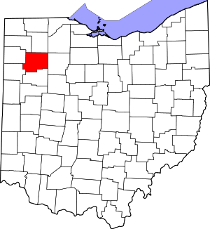 Map of Ohio highlighting Putnam County | |
| Townships | ||
| CDP | ||
| Unincorporated communities | ||
| Ghost towns | ||
| Authority control |
|
|---|