Laurel Hill Tunnel
Laurel Hill Tunnel is one of three original tunnels on the Pennsylvania Turnpike which were abandoned (this one in 1964) after two massive realignment projects.
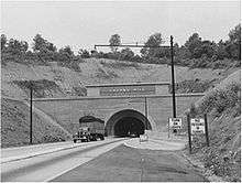 Laurel Hill Tunnel in 1942 | |
| Overview | |
|---|---|
| Line | South Penn abandoned |
| Location | Laurel Hill Westmoreland and Somerset counties, Pennsylvania |
| Coordinates | 40°6′0.4″N 79°13′38.4″W |
| Status | Closed to traffic, leased to Chip Ganassi Racing for testing |
| Crosses | Laurel Hill |
| Operation | |
| Work begun | 1881, railway 1938, highway |
| Constructed | 1881–1885, railway 1938–1940, highway |
| Opened | October 1, 1940 |
| Closed | October 30, 1964, I-70/I-80S |
| Owner | Pennsylvania Turnpike Commission |
| Technical | |
| Length | 5,450 ft (1,660 m), railway 4,541 ft (1,384 m), highway |
| No. of lanes | 2 |
The Laurel Hill Tunnel was bored under the border between Westmoreland and Somerset counties. The others, located further east, were the Sideling Hill (Fulton County) and Rays Hill Tunnels (under the border of Fulton and Bedford counties). All of the original tunnels except Allegheny Mountain were part of the never-completed South Pennsylvania Railroad system.
Laurel Hill Tunnel is 4,541 feet (1,384 m) long. Its western portal is marginally visible from the current eastbound turnpike roadway at milepost 99.3.
Bypass
From the turnpike's opening in 1940 until the realignment projects, the tunnels were bottlenecks due to reduced speeds with opposing traffic in the same tubes. Four other tunnels on the turnpike—Allegheny Mountain, Tuscarora Mountain, Kittatinny Mountain, and Blue Mountain—each had a second tube bored, as it was determined in these instances to be the less expensive option. All of the original tunnels except Allegheny Mountain were part of the never-completed South Pennsylvania Railroad system.
Unlike the Sideling Hill and Rays Hill tunnels, the Laurel Hill Tunnel is not on the bypassed section commonly known as the Abandoned Pennsylvania Turnpike, and the property is still owned by the Pennsylvania Turnpike Commission. In addition, the tunnel is not open to the public. It is routinely patrolled by the Pennsylvania State Police, who strictly enforce "no trespassing" signs.[1]
The stretch of the highway that bypasses Laurel Hill Tunnel climbs to the Turnpike's height elevation, 2,603 feet, at Mile 100.45, just within the border of Somerset County.
Current use
The tunnel is currently used by Chip Ganassi Racing for high-speed race car aerodynamic testing. The tunnel has been repaved, equipped with climate control, safety equipment, and data collection systems. The tunnel was first used for testing in 2004 to develop the G-Force Indycar.[2][3]
References
- "Abandoned Turnpike FAQ". Retrieved September 24, 2016.
- "The Secrets of Laurel Hill Revealed". Retrieved October 4, 2014.
- "The Secret Racing Test Tunnel No One Wants to Talk About". Road and Track. Retrieved January 11, 2015.
| Completed highways | ||
|---|---|---|
| Partially-completed highways | ||
| Tunnels and bridges | ||
| Aborted expansion plans | ||
| Historical structures | ||
| Tolling systems | ||