Lapakahi State Historical Park
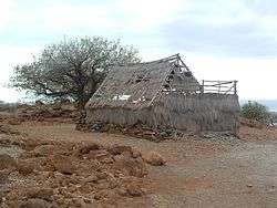
Lapakahi State Historical Park is a large area of ruins from an Ancient Hawaiian fishing village in the North Kohala District on the Big Island of Hawaiʻi.[2][3] Offshore is the Lapakahi Marine Life Conservation District.
Lapakahi Complex | |
 | |
 | |
| Nearest city | Hawi, Hawaii |
|---|---|
| Coordinates | 20°10′31″N 155°53′50″W |
| Area | 2,560 acres (1,040 ha) |
| Architectural style | Ancient Hawaiian |
| NRHP reference No. | 73000654[1] |
| Added to NRHP | July 2, 1973[1] |
The name lapa kahi means "single ridge" in the Hawaiian Language, and applied to the ahupuaʻa, an ancient land division that ran from the sea up to Kohala Mountain.[4] It is located off of ʻAkoni Pule Highway (Route 270), 12.4 miles (20.0 km) north of Kawaihae, Hawaii.[5] It is state archaeological site 10-02-2245,[6] and was added to the National Register of Historic Places on July 2, 1973 as site 73000654.[1] Just to the north, Māhukona Beach Park is on a bay where a sugar mill once stood.[7]
References
- "National Register Information System". National Register of Historic Places. National Park Service. July 9, 2010.
- Lapakahi State Historical Park brochure on Hawaiʻi State Park web site
- Archaeological Inventory Survey for a Road Realignment in Kohala T.S. Dye, January 2008
- Lloyd J. Soehren (2010). "lookup of lapakahi ". in Hawaiian Place Names. Ulukau, the Hawaiian Electronic Library. Retrieved October 30, 2010.
- "Lapakahi State Historical Park". official Hawaii's State Park web site. Hawai'i Department of Land and Natural Resources. Retrieved November 4, 2018.
- Historic sites in Hawaiʻi County on state web site
- "North Kohala map". Shoreline access. on official Hawaiʻi County web site. Archived from the original on July 8, 2011. Retrieved July 27, 2010.
| Wikimedia Commons has media related to Lapakahi State Historical Park. |
| Topics | |
|---|---|
| Lists by state |
|
| Lists by insular areas | |
| Lists by associated state | |
| Other areas | |
| Related | |
| |
This article is issued from Wikipedia. The text is licensed under Creative Commons - Attribution - Sharealike. Additional terms may apply for the media files.