Laghouat Province
Laghouat (Arabic: ولاية الأغواط) is a province (wilaya) in central Algeria. forty-eight bearing the number (03) within the administrative division of the country, bordered to the north Tiaret Province, to the west El Bayadh Province, to the south Ghardaia Province and from the east by Djelfa Province. The capital is Laghouat City. Mediated by this region Saharan Atlas and thus the region of steppe. It is famous for its palm trees and its generosity as it is known for raising livestock due to its pastoral and steppe character.
Laghouat Province ولاية الأغواط | |
|---|---|
 .jpg) | |
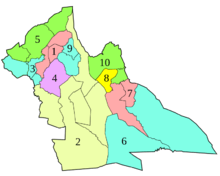
.svg.png) Map of Algeria highlighting Laghouat | |
| Coordinates: 33°48′N 2°53′E | |
| Country | |
| Capital | Laghouat |
| Area | |
| • Total | 25,057 km2 (9,675 sq mi) |
| Population (2008)[1] | |
| • Total | 477,328 |
| • Density | 19/km2 (49/sq mi) |
| Time zone | UTC+01 (CET) |
| Area Code | +213 (0) 29 |
| ISO 3166 code | DZ-03 |
| Districts | 10 |
| Municipalities | 24 |
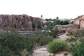
On the tourist side, the district of Kef El Melh (the mountain of salt) in the municipality of Tadjrouna is near the border with El Bayadh Province the most important tourist area in the state and there is the largest tourist headquarters for the state in the Kordan palace Or crown angle. There are also tourist areas and natural sights such as Al-Ghaisheh, Taouila, Lalmaya, Ein Sefsifah, Al-Huwaita and Madana. The Talemzane crater, with its nozzle resulting from the fall of the meteorite in ancient times, is the fourth age and the second largest in size in the world after which there is Arizona and is found in the municipality of Hassi Delaa to the south.
The state is also famous for its production natural gas as it contains important fields in the region of Hassi R'Mel and has huge reserves of this vital material which qualified Algeria to occupy an important position globally in the field of energy. This material is pumped through several tubes to feed Europe.
Geography
Location and Nature
Located at an altitude of 750 m, the Laghouat Province is part of the Saharan Atlas Mountains chain with some peaks above 2,000 m "Djebel Amour: 2,200 m"
Laghouat is a Province in the south of Algeria and away from Algiers by about 400 km and its orchards and buildings and mosques span the antique through a vast steppe and mountains tall and green pastures, where the largest stream tributary of Wadi Al-Tawil Chelif River originates from its mountains,and M'zi River where a municipality is called by its name.
The area is characterized by its pastoral, agricultural and mountainous steppe character, as it contains a region of a purely industrial nature, which is Hassi R'mel. As it is possible to classify the state from this side as an energy mandate in the first place.
Terrain
The Province of Laghouat is located between Tell and desert at the foothills of the Saharan Atlas chain with its two sides Amour Range west of the Province and the mountains of Ouled Nile east of it, and this can be divided The Province is divided into three main regions:
Saharan Atlas
It is located in the northwest of the state, specifically north of the mountains of Djebel Amour, and is characterized by a height between 1000 and 1700 meters from the surface of sea. We can distinguish them into two sub-regions: the High Highlands area in the north and a mountainous area in the south. The Districts of : Gueltet Sidi Saâd, Aflou District, Brida District, El Ghicha District and Oued Morra District. The most important characteristic of this region is that it is the source of the most important Rivers in Algeria like: Chelif River through its tributary, Wadi el-Taweel and Wadi Djedi through its tributary M'zi River. It is also distinguished by the presence of forests The Green Dam.
steppe
It is located in the middle, characterized by a height between 700 and 1000 AD. It is known as a grazing area, as it contains many steppe plants and herbs. This region includes most of the state's vegetation except for the green dam forests in the mountainous region. The district of Sidi Makhlouf; Laghouat District, the northern part of the district of Ain Madhi.
Desert
In the southern part of the state of Laghouat, it includes what is known as the desert plateau, and includes the Hassi R'Mel District, the south of the Ksar El Hirane District and the south of the Ain Madhi District. It is distinguished by its low vegetation cover, as it is confined to the plant Peganum, except for some hills here and there that are distinguished by the diversity of its plants Ziziphus spina-christi, Pistacia atlantica and the various herbs flowers in the spring.
Administrative division
The province is divided into 10 districts (daïras), which are further divided into 24 communes or municipalities.
Districts
Economy
Transportation
| Index | The number | Length |
| National Road | 3 | 403 km |
| Number of Airports | 2 | |
| Railways | - | 0km |

Transportation is the most important economic sector for any country, so taking care of it and giving it its strategic position was necessary and vital. Laghouat Province contains three national methods:
- The Trans-Saharan Road: The national road number one links Algiers to Lagos in the future, and it connects the city of Laghouat with the city of Djelfa in the north and the city of Ghardaia in the south.
- National Road No. (23): connects Laghouat to Tiaret towards the West Algerian (Mostaganem).
- Road National No. (47): connects Aflou with El Bayadh towards South West (Aïn Séfra).
The state also has two airports, one of which is a local airport that is used mainly to transport pilgrims which is Laghouat Airport called by the martyr Moulay Ahmed Madgari. The second one is of an economic nature, and it is an airport Hassi R'mel that is used mainly by the National Fuel Company Sonatrach to transport its tires, experts, and businessmen contracting with it.
| The distance in kilometers between Laghouat and some cities and villages [2] |
|---|
| from - to | Distance in km |
|---|---|
Laghouat - Masaad |
80 |
Laghouat - Aflou |
110 |
Laghouat - Hassi R'mel |
120 |
Laghouat - Djelfa |
100 |
Laghouat - Aïn Oussera |
200 |
Laghouat - Ghardaia |
200 |
Laghouat - El Bayadh |
250 |
Laghouat - Tiaret |
290 |
Laghouat - Blida |
345 |
Laghouat - Algiers |
400 |
Laghouat - Ouargla |
400 |
Laghouat - Oran |
500 |
Laghouat - Constantine |
555 |
Laghouat - Adrar |
1042 |
Laghouat - Tamanrasset |
1600 |
Laghouat - Cape Town |
13000 |
Energy
Laghouat Province is considered the second most important energy mandate in Algeria after Ouargla Province because it contains one of the most important gas fields in Africa in the region of Hassi R'mel, and it contains many electricity production stations in the region Telegmat near Hassi R'mel and the area of Kheneg which contains the largest solar PV plant Algeria with a capacity of 60 MW.
CPV EKP solar power station definition
This station is located 5 km from the municipality of Kheneg and 10 km from Laghouat in Algeria.

It sits on an area of 120 hectares and produces more than 300 MWh megawatt hours as an average daily of electricity. It contains more than 240 thousand solar panels distributed over 5460 matrices, 2040 junction Box of three levels, 120 Inverter, and 60 transformer. It is connected to a high-voltage electricity transmission network 60 kV by the lifting station which contains 03 transformers with a capacity of 20 MVA each.
Laborers: 77 includes one of them 19 an employee belonging to the company responsible for the station "SKTM", and the rest are guard workers.
.


See also
References
- Office National des Statistiques, Recensement General de la Population et de l’Habitat 2008 Archived 2008-07-24 at the Wayback Machine Preliminary results of the 2008 population census. Accessed on 2008-07-02.
- /villes-a-proximit%C3%A9.html%C3%A9.html Les villes à proximité
- The most sheep breeding areas in Algeria - YouTube
- Laghouat: Opération de vaccination du bétail contre la brucellose Algerie Confluences Algerie Confluences
- Algérie Presse Service - Près de 217,000 têtes de bétail vaccinées contre la brucellose à Laghouat <! - bot generator address ->
| Flag of Algeria | |