Lafayette County, Mississippi
Lafayette County is a county in the U.S. state of Mississippi. As of the 2010 census, the population was 47,351.[1] Its county seat is Oxford.[2] The local pronunciation of the name is "la-FAY-et." The county's name honors Marquis de Lafayette, a French military hero and American general who fought during the American Revolutionary War.[3]
Lafayette County | |
|---|---|
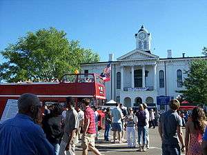 Lafayette County courthouse in Oxford | |
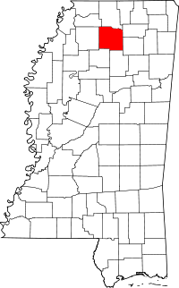 Location within the U.S. state of Mississippi | |
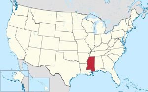 Mississippi's location within the U.S. | |
| Coordinates: 34°22′N 89°29′W | |
| Country | |
| State | |
| Founded | 1836 |
| Named for | Marquis de Lafayette |
| Seat | Oxford |
| Largest city | Oxford |
| Area | |
| • Total | 679 sq mi (1,760 km2) |
| • Land | 632 sq mi (1,640 km2) |
| • Water | 47 sq mi (120 km2) 7.0% |
| Population (2010) | |
| • Total | 47,351 |
| • Estimate (2018) | 54,793 |
| • Density | 70/sq mi (27/km2) |
| Time zone | UTC−6 (Central) |
| • Summer (DST) | UTC−5 (CDT) |
| Congressional district | 1st |
| Website | lafayettems |
The Oxford, MS Micropolitan Statistical Area includes all of Lafayette County. The County is policed by the Lafayette County Sheriff's Department.
Lafayette County is often regarded as the inspiration for Yoknapatawpha County, the fictional setting of many of William Faulkner's stories.
Geography
According to the U.S. Census Bureau, the county has a total area of 679 square miles (1,760 km2), of which 632 square miles (1,640 km2) is land and 47 square miles (120 km2) (7.0%) is water.[4]
Major highways


Adjacent counties
- Marshall County (north)
- Union County (northeast)
- Pontotoc County (southeast)
- Calhoun County (south)
- Yalobusha County (southwest)
- Panola County (west)
- Tate County (northwest)
National protected area
Demographics
| Historical population | |||
|---|---|---|---|
| Census | Pop. | %± | |
| 1840 | 6,531 | — | |
| 1850 | 14,069 | 115.4% | |
| 1860 | 16,125 | 14.6% | |
| 1870 | 18,802 | 16.6% | |
| 1880 | 21,671 | 15.3% | |
| 1890 | 20,553 | −5.2% | |
| 1900 | 22,110 | 7.6% | |
| 1910 | 21,883 | −1.0% | |
| 1920 | 19,243 | −12.1% | |
| 1930 | 19,978 | 3.8% | |
| 1940 | 21,257 | 6.4% | |
| 1950 | 22,798 | 7.2% | |
| 1960 | 21,355 | −6.3% | |
| 1970 | 24,181 | 13.2% | |
| 1980 | 31,030 | 28.3% | |
| 1990 | 31,826 | 2.6% | |
| 2000 | 38,744 | 21.7% | |
| 2010 | 47,351 | 22.2% | |
| Est. 2018 | 54,793 | [5] | 15.7% |
| U.S. Decennial Census[6] 1790-1960[7] 1900-1990[8] 1990-2000[9] 2010-2013[1] | |||
2010 Census[10]
As of the census of 2010, there were 45,859 people. There were 21,646 housing units. The medium age was 26.8 years old. The racial makeup of the county was 71.5% white, 23.9% Black or African American, 0.3% Native American, and 2.0% Asian. 2.3% of the population were Hispanic or Latino of any race.
2000 Census
As of the census[11] of 2000, there were 38,744 people, 14,373 households, and 8,321 families residing in the county. The population density was 61 people per square mile (24/km²). There were 16,587 housing units at an average density of 26 per square mile (10/km²). The racial makeup of the county was 71.85% White, 25.05% Black or African American, 0.16% Native American, 1.67% Asian, 0.01% Pacific Islander, 0.42% from other races, and 0.84% from two or more races. 1.10% of the population were Hispanic or Latino of any race.
The largest European ancestry groups in Lafayette county are:[12]
- 13.4% English
- 12.5% Irish
- 9.1% German
- 4.4% Scots-Irish
- 2.8% Scottish
- 1.1% Polish
- 1.0% Welsh
Many people in Mississippi may claim Irish ancestry because of the term "Scots-Irish", but most of the time in Mississippi this term is used for those with Ulster Scots roots rather than Irish Catholics.[13]
In 2000, there were 14,373 households out of which 26.90% had children under the age of 18 living with them, 43.20% were married couples living together, 11.40% had a female householder with no husband present, and 42.10% were non-families. 29.10% of all households were made up of individuals and 7.80% had someone living alone who was 65 years of age or older. The average household size was 2.36 and the average family size was 2.97.
In the county, the population was spread out with 19.50% under the age of 18, 27.10% from 18 to 24, 26.30% from 25 to 44, 17.10% from 45 to 64, and 9.80% who were 65 years of age or older. The median age was 27 years. For every 100 females there were 96.70 males. For every 100 females age 18 and over, there were 94.60 males.
The median income for a household in the county was $28,517, and the median income for a family was $42,910. Males had a median income of $30,964 versus $21,207 for females. The per capita income for the county was $16,406. About 10.20% of families and 21.30% of the population were below the poverty line, including 15.60% of those under age 18 and 19.40% of those age 65 or over.
Communities


City
- Oxford (county seat and largest municipality)
Census-designated place
Unincorporated communities
Politics
Sheriff F.D. “Buddy" East died in office in September 2018. He had been elected to office twelve times, starting in 1972 and was the state's longest-serving sheriff and at the time of his death the longest-serving sheriff in the nation.[14]
| Year | Republican | Democratic | Third parties |
|---|---|---|---|
| 2016 | 55.4% 10,872 | 40.6% 7,969 | 4.1% 802 |
| 2012 | 56.8% 11,075 | 41.5% 8,091 | 1.7% 339 |
| 2008 | 55.7% 10,278 | 43.3% 7,997 | 1.0% 185 |
| 2004 | 58.5% 9,004 | 40.4% 6,218 | 1.2% 179 |
| 2000 | 55.9% 7,081 | 40.5% 5,139 | 3.6% 458 |
| 1996 | 47.2% 4,753 | 46.1% 4,646 | 6.7% 675 |
| 1992 | 46.1% 5,251 | 45.8% 5,224 | 8.1% 922 |
| 1988 | 59.3% 5,841 | 40.3% 3,967 | 0.5% 44 |
| 1984 | 62.1% 6,006 | 37.7% 3,646 | 0.3% 28 |
| 1980 | 45.6% 4,366 | 51.1% 4,887 | 3.3% 318 |
| 1976 | 44.7% 3,735 | 52.4% 4,375 | 2.9% 241 |
| 1972 | 76.9% 5,391 | 22.0% 1,545 | 1.1% 75 |
| 1968 | 20.1% 1,235 | 25.7% 1,578 | 54.2% 3,329 |
| 1964 | 81.6% 3,202 | 18.4% 720 | |
| 1960 | 24.1% 705 | 44.8% 1,308 | 31.1% 909 |
| 1956 | 21.3% 575 | 72.9% 1,968 | 5.9% 158 |
| 1952 | 26.9% 868 | 73.1% 2,363 | |
| 1948 | 2.4% 48 | 37.6% 744 | 60.0% 1,188 |
| 1944 | 3.9% 87 | 96.1% 2,148 | |
| 1940 | 2.9% 65 | 97.0% 2,188 | 0.1% 2 |
| 1936 | 1.5% 26 | 98.2% 1,652 | 0.3% 5 |
| 1932 | 1.4% 26 | 98.4% 1,831 | 0.2% 4 |
| 1928 | 7.4% 131 | 92.7% 1,652 | |
| 1924 | 4.5% 89 | 93.6% 1,848 | 1.9% 37 |
| 1920 | 26.6% 321 | 72.4% 873 | 1.0% 12 |
| 1916 | 3.3% 47 | 95.8% 1,370 | 0.9% 13 |
| 1912 | 2.6% 28 | 91.3% 973 | 6.1% 65 |
See also
References
- "State & County QuickFacts". United States Census Bureau. Archived from the original on June 7, 2011. Retrieved August 15, 2014.
- "Find a County". National Association of Counties. Retrieved 2011-06-07.
- Gannett, Henry (1905). The Origin of Certain Place Names in the United States. Government Printing Office. pp. 178.
- "2010 Census Gazetteer Files". United States Census Bureau. August 22, 2012. Archived from the original on September 28, 2013. Retrieved November 6, 2014.
- "County Population Totals and Components of Change: 2010-2018". Retrieved April 20, 2019.
- "U.S. Decennial Census". United States Census Bureau. Retrieved November 6, 2014.
- "Historical Census Browser". University of Virginia Library. Retrieved November 6, 2014.
- "Population of Counties by Decennial Census: 1900 to 1990". United States Census Bureau. Retrieved November 6, 2014.
- "Census 2000 PHC-T-4. Ranking Tables for Counties: 1990 and 2000" (PDF). United States Census Bureau. Retrieved November 6, 2014.
- Bureau, U. S. Census. "U.S. Census website". United States Census Bureau. Retrieved 2019-05-09.
- "U.S. Census website". United States Census Bureau. Retrieved 2008-01-31.
- American FactFinder Archived 2020-02-12 at Archive.today. Factfinder.census.gov. Retrieved on 2013-08-17.
- Census 2000 Map - Top U.S. Ancestries by County
- Apel, Therese (8 October 2018). "Mississippi's longest-serving sheriff dies after 46 years in office". Clarion-Ledger. Retrieved 10 September 2018.
- Leip, David. "Dave Leip's Atlas of U.S. Presidential Elections". uselectionatlas.org. Retrieved 2018-03-05.
External links
- Lafayette County Records (MUM00256) owned by the University of Mississippi, Archives and Special Collections.
Places adjacent to Lafayette County, Mississippi | ||||||||||
|---|---|---|---|---|---|---|---|---|---|---|
| ||||||||||
Municipalities and communities of Lafayette County, Mississippi, United States | ||
|---|---|---|
| City | Map of Mississippi highlighting Lafayette County | |
| Towns | ||
| CDP | ||
| Other unincorporated communities | ||
| Ghost town | ||
.svg.png)
| Authority control |
|
|---|