La Léchère
La Léchère (French pronunciation: [laleʃɛʁ]) is a commune in the Savoie department in the Auvergne-Rhône-Alpes region in south-eastern France. It is situated in the Isère valley, between Albertville and Moûtiers. It was formed in 1972 by the merger of the former communes Notre-Dame-de-Briançon, Celliers, Doucy, Naves, Petit-Cœur and Pussy.[2] On 1 January 2019, the former communes Bonneval and Feissons-sur-Isère were merged into La Léchère.[3]
La Léchère | |
|---|---|
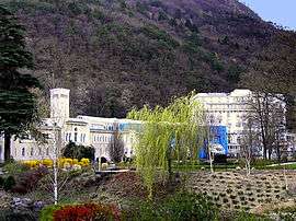 The spa in La Léchère | |
Location of La Léchère 
| |
 La Léchère  La Léchère | |
| Coordinates: 45°31′59″N 6°28′27″E | |
| Country | France |
| Region | Auvergne-Rhône-Alpes |
| Department | Savoie |
| Arrondissement | Albertville |
| Canton | Moûtiers |
| Intercommunality | Vallées d'Aigueblanche |
| Government | |
| • Mayor (2014–2020) | Jean-François Rochaix |
| Area 1 | 134.54 km2 (51.95 sq mi) |
| Population (2017-01-01)[1] | 2,586 |
| • Density | 19/km2 (50/sq mi) |
| Time zone | UTC+01:00 (CET) |
| • Summer (DST) | UTC+02:00 (CEST) |
| INSEE/Postal code | 73187 /73260 |
| Elevation | 394–2,829 m (1,293–9,281 ft) |
| 1 French Land Register data, which excludes lakes, ponds, glaciers > 1 km2 (0.386 sq mi or 247 acres) and river estuaries. | |
See also
References
- "Populations légales 2017". INSEE. Retrieved 6 January 2020.
- Commune de La Léchère (73187), INSEE
- Arrêté préfectoral 15 November 2018 (in French)
| Wikimedia Commons has media related to La Léchère. |
This article is issued from Wikipedia. The text is licensed under Creative Commons - Attribution - Sharealike. Additional terms may apply for the media files.