Cognin
Cognin is a commune in the Savoie department in the Auvergne-Rhône-Alpes region in south-eastern France.
Cognin | |
|---|---|
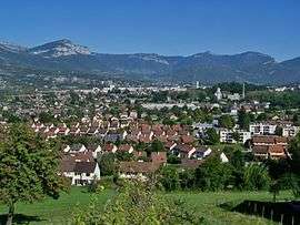 A general view of Cognin | |
.svg.png) Coat of arms | |
Location of Cognin 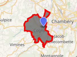
| |
 Cognin  Cognin | |
| Coordinates: 45°33′47″N 5°54′00″E | |
| Country | France |
| Region | Auvergne-Rhône-Alpes |
| Department | Savoie |
| Arrondissement | Chambéry |
| Canton | Chambéry-3 |
| Intercommunality | Chambéry métropole |
| Government | |
| • Mayor | Florence Vallin-Balas |
| Area 1 | 4.48 km2 (1.73 sq mi) |
| Population (2017-01-01)[1] | 6,204 |
| • Density | 1,400/km2 (3,600/sq mi) |
| Time zone | UTC+01:00 (CET) |
| • Summer (DST) | UTC+02:00 (CEST) |
| INSEE/Postal code | 73087 /73160 |
| Elevation | 269–451 m (883–1,480 ft) (avg. 299 m or 981 ft) |
| Website | www.cognin.fr |
| 1 French Land Register data, which excludes lakes, ponds, glaciers > 1 km2 (0.386 sq mi or 247 acres) and river estuaries. | |
Geography
The Hyères river forms the commune's western border.
See also
External links
| Wikimedia Commons has media related to Cognin. |
Cognin centre.
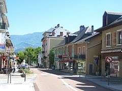
Route nationale 6 in Cognin centre.
| Authority control |
|
|---|
This article is issued from Wikipedia. The text is licensed under Creative Commons - Attribution - Sharealike. Additional terms may apply for the media files.