La Bastide-sur-l'Hers
La Bastide-sur-l'Hers is a French commune in the Ariège department in the Occitanie region of southwestern France.[2]
La Bastide-sur-l'Hers | |
|---|---|
.svg.png) Coat of arms | |
Location of La Bastide-sur-l'Hers 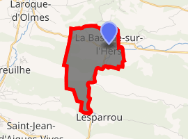
| |
 La Bastide-sur-l'Hers  La Bastide-sur-l'Hers | |
| Coordinates: 42°57′24″N 1°54′35″E | |
| Country | France |
| Region | Occitanie |
| Department | Ariège |
| Arrondissement | Pamiers |
| Canton | Mirepoix |
| Intercommunality | CC du Pays de Mirepoix |
| Government | |
| • Mayor (2008–2014) | Jacky Barbe |
| Area 1 | 4.77 km2 (1.84 sq mi) |
| Population (2017-01-01)[1] | 678 |
| • Density | 140/km2 (370/sq mi) |
| Time zone | UTC+01:00 (CET) |
| • Summer (DST) | UTC+02:00 (CEST) |
| INSEE/Postal code | 09043 /09600 |
| Elevation | 428–721 m (1,404–2,365 ft) (avg. 438 m or 1,437 ft) |
| 1 French Land Register data, which excludes lakes, ponds, glaciers > 1 km2 (0.386 sq mi or 247 acres) and river estuaries. | |
The inhabitants of the commune are known as Bastidhersois or Bastidhersoises.[3]
Geography
La Bastide-sur-l'Hers is located some 28 km south-east of Pamiers and 3 km north-east of Lavelanet. Access to the commune is by the D620 road from Laroque-d'Olmes in the north-west which goes east through the commune and the village and continues east to Le Peyrat. The D16 comes from L'Aiguillon in the south and passes north inside the eastern border of the commune to the village then continues north to join the D28A south of Léran. A former railway line now a walking trail passes through the commune from west to east just north of the village. The commune has two large belts of forest across the centre and south with most of the rest of the commune farmland.[4][5]
The Hers river flows from the south forming the south-eastern border before passing through the village and continuing east to eventually join the Ariège at Cintegabelle. The Ruiseeau des Écrevisses forms the southern border of the commune as it flows east to join the Hers. The Ruisseau de Pépoulant also flows east across the commune a little further north and joins the Hers.[4][5]
Toponymy
La Bastide-sur-l'Hers appears as la Baftide de Cougoust on the 1750 Cassini Map[6] and as la Bastide on the 1790 version.[7]
Administration
| From | To | Name | Party | Position |
|---|---|---|---|---|
| 1989 | 2020 | Jacky Barbe |
(Not all data is known)
Demography
In 2010 the commune had 724 inhabitants. The evolution of the number of inhabitants is known from the population censuses conducted in the commune since 1793. From the 21st century, a census of communes with fewer than 10,000 inhabitants is held every five years, unlike larger communes that have a sample survey every year.[Note 1]
| 1793 | 1800 | 1806 | 1821 | 1831 | 1836 | 1841 | 1846 | 1851 |
|---|---|---|---|---|---|---|---|---|
| 501 | 490 | 573 | 566 | 620 | 626 | 585 | 673 | 706 |
| 1856 | 1861 | 1866 | 1872 | 1876 | 1881 | 1886 | 1891 | 1896 |
|---|---|---|---|---|---|---|---|---|
| 679 | 763 | 774 | 817 | 877 | 912 | 965 | 981 | 1,024 |
| 1901 | 1906 | 1911 | 1921 | 1926 | 1931 | 1936 | 1946 | 1954 |
|---|---|---|---|---|---|---|---|---|
| 976 | 951 | 982 | 956 | 929 | 880 | 797 | 751 | 850 |
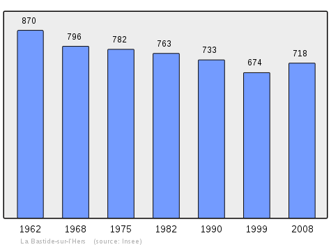
| 1962 | 1968 | 1975 | 1982 | 1990 | 1999 | 2006 | 2010 | - |
|---|---|---|---|---|---|---|---|---|
| 870 | 796 | 782 | 763 | 733 | 674 | 710 | 724 | - |
Sites and Monuments
- The Church of Our Lady of the Assumption. The keystone indicates a date of 1527. An organ was installed there in 2008 following an anonymous bequest to the pastor of the parish, who also donated. This instrument, with two keyboards and pedals, was built by Krischer (Rouen) in 1893.
- A Protestant church was built in 1826
- A Covered Market from the late 19th century
There is a Monumental Painting (18th century)![]()
Notable people linked to the commune
- Philippe Tissié was born in La Bastide-sur-l'Hers on 18 October 1852.
- Annie Campayo wife of SABY was born in la Bastide-sur-l'Hers on 3 February 1951.
See also
Notes and references
Notes
- At the beginning of the 21st century, the methods of identification have been modified by Law No. 2002-276 of 27 February 2002, the so-called "law of local democracy" and in particular Title V "census operations" allows, after a transitional period running from 2004 to 2008, the annual publication of the legal population of the different French administrative districts. For communes with a population greater than 10,000 inhabitants, a sample survey is conducted annually and the entire territory of these communes is taken into account at the end of the period of five years. The first "legal population" after 1999 under this new law came into force on 1 January 2009 and was based on the census of 2006.
References
- "Populations légales 2017". INSEE. Retrieved 6 January 2020.
- La Bastide-sur-l'Hers on Lion1906
- Inhabitants of Ariège (in French)
- La Bastide-sur-l'Hers on Google Maps
- La Bastide-sur-l'Hers on the Géoportail from National Geographic Institute (IGN) website (in French)
- la Baftide de Cougoust on the 1750 Cassini Map
- la Bastide on the 1790 Cassini Map
- List of Mayors of France (in French)
- Ministry of Culture, Palissy IM09000075 Monumental Painting (in French)
External links
| Wikimedia Commons has media related to La Bastide-sur-l'Hers. |