Kunszentmárton District
Kunszentmárton (Hungarian: Kunszentmártoni járás) is a district in southern part of Jász-Nagykun-Szolnok County. Kunszentmárton is also the name of the town where the district seat is found. The district is located in the Northern Great Plain Statistical Region. This district is a part of Nagykunság historical and geographical region.
Kunszentmárton District Kunszentmártoni járás | |
|---|---|
 Coat of arms | |
 Kunszentmárton District within Hungary and Jász-Nagykun-Szolnok County. | |
| Country | |
| County | Jász-Nagykun-Szolnok |
| District seat | Kunszentmárton |
| Area | |
| • Total | 576.49 km2 (222.58 sq mi) |
| Area rank | 5th in Jász-Nagykun-Szolnok |
| Population (2011 census) | |
| • Total | 36,147 |
| • Rank | 5th in Jász-Nagykun-Szolnok |
| • Density | 63/km2 (160/sq mi) |
Geography
Kunszentmárton District borders with Szolnok District and Mezőtúr District to the north, Szarvas District (Békés County) to the east, Szentes District and Csongrád District (Csongrád County) to the south, Cegléd District and Tiszakécske District (Bács-Kiskun County) to the west. The number of the inhabited places in Kunszentmárton District is 11.
Municipalities
The district has 2 towns, 2 large villages and 7 villages. (ordered by population, as of 1 January 2012)[1]
- Cibakháza (4,327)
- Csépa (1,535)
- Cserkeszőlő (2,090)
- Kunszentmárton (8,373) – district seat
- Nagyrév (729)
- Öcsöd (3,199)
- Szelevény (1,050)
- Tiszaföldvár (11,120)
- Tiszainoka (415)
- Tiszakürt (1,353)
- Tiszasas (985)
The bolded municipalities are cities, italics municipalities are large villages.
Demographics
Religion in Kunszentmárton District (2011 census)
In 2011, it had a population of 36,147 and the population density was 63/km².
| Year | County population[2] | Change |
|---|---|---|
| 2011 | 36,147 | n/a |
Ethnicity
Besides the Hungarian majority, the main minorities are the Roma (approx. 1,000) and German (150).
Total population (2011 census): 36,147
Ethnic groups (2011 census):[3] Identified themselves: 31,213 persons:
- Hungarians: 29,687 (95.11%)
- Gypsies: 1,137 (3.64%)
- Others and indefinable: 389 (1.25%)
Approx. 5,000 persons in Kunszentmárton District did not declare their ethnic group at the 2011 census.
Religion
Religious adherence in the county according to 2011 census:[4]
- Catholic – 10,103 (Roman Catholic – 10,055; Greek Catholic – 48);
- Reformed – 4,281;
- Evangelical – 220;
- other religions – 349;
- Non-religious – 10,888;
- Atheism – 376;
- Undeclared – 9,930.
Transport
Road network
- The
_Otszogletu_kek_tabla.svg.png)
The road connect Békéscsaba to the highway network. - Main road
_Otszogletu_zold_tabla.svg.png)
_Otszogletu_zold_tabla.svg.png)
- Main road
_Otszogletu_zold_tabla.svg.png)
_Otszogletu_zold_tabla.svg.png)
- Main road
_Otszogletu_zold_tabla.svg.png)
_Otszogletu_zold_tabla.svg.png)
Railway network
- Line 130 (N→S): Tiszatenyő (120)... – Kunszentmárton District (2 municipalities: Tiszaföldvár, Kunszentmárton) – ...Hódmezővásárhely (135)
- Line 146 (W→E): Kecskemét (140, 142, 152)... – Kunszentmárton District (4 municipalities: Tiszasas, Csépa, Szelevény, Kunszentmárton)
Gallery
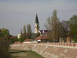 Kunszentmárton, St. Martin Church
 Körös river near Kunszentmárton
 Aerial view of Tiszaföldvár
 Main entrance of thermal bath in Cserkeszőlő
See also
References
- A KSH 2012. évi helységnévkönyve
- népesség.com, "Kunszentmártoni járás népessége"
- 4.1.6.1 A népesség nemzetiség szerint, 2011, (in Hungarian)
- 4.1.7.1 A népesség vallás, felekezet szerint, 2011, (in Hungarian)