Kottakuppam
Kottakuppam is a panchayat town in Viluppuram district in the Indian state of Tamil Nadu in the East Coast Road from Chennai to Pondicherry, Kottakuppam is a landmark of tradition. In the book Arts of Islam. It is believed that there were Forts in Kottakuppam. But there is no clear evidence for this. In the map there is no area named Kottakuppam before 200 years.
Kottakuppam | |
|---|---|
town panchayat | |
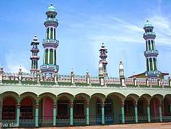 kottakuppam jamia masjid | |
 Kottakuppam Location in Tamil Nadu, India | |
| Coordinates: 11°59′29″N 79°50′29″E | |
| Country | |
| State | Tamil Nadu |
| District | Viluppuram |
| Population (2011) | |
| • Total | 31,726 |
| Languages | |
| • Official | Tamil |
| Time zone | UTC+5:30 (IST) |
| PIN | 605 104 |
| Telephone code | 0413 |
| Vehicle registration | PYO1 |
| Website | www.kottakuppam.in |
In the French Rule, Kottakuppam adherent to Muthialpet serves as camp place for foreigners. From this area the adjacent regions had developed, namely Chinnamudaliar Chavady, Periamudaliar Chavady. It was only after 200 years, Kottakuppam has got its name ‘Kottam’ refers to the land area and ‘Kuppam’ refers to the coastal area. Since this area lies near the coastal region, tt got its name ‘Kottaikuppam’. The Southern part of this region is now known as Kottamedu. Kottakuppam is a Town Panchayat city in district of Viluppuram, Tamil Nadu.
Kottakuppam city is divided into 18 wards for which elections are held every 5 years. The Kottakuppam Town Panchayat has population of 31,726 of which 15,690 are males while 16,036 are females as per report released by Census India 2011. Major populations in Kottakuppam are Muslims. Kottakuppam Jamia Masjid was built by Arcot Nawab in 1867. Now it is extended and decorated to make it showy by the people in and around Kottaikuppam.