Konia, Cyprus
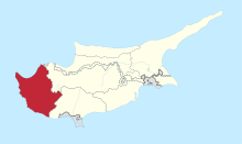
Konia (Greek: Κονιά)[2] is a village in the Paphos District of Cyprus, located 3 km east of Paphos. In the northwest is Anavargos village, Armou in the northeast, Marathounta East and Yeroskipou in the South.[3]
Konia Κονιά | |
|---|---|
 Konia Location in Cyprus | |
| Coordinates: 34°47′2″N 32°27′30″E | |
| Country | |
| District | Paphos District |
| Elevation | 189 m (620 ft) |
| Population (2001)[1] | |
| • Total | 1,100 |
| Time zone | UTC+2 (EET) |
| • Summer (DST) | UTC+3 (EEST) |
| Postal code | 6011 |
Topography
Built at an altitude of 200 meters the village of Konia with about 2,000 inhabitants, is constantly developing.
References
- Census 2001
- "Konia Map | Cyprus Google Satellite Maps". www.maplandia.com. Retrieved 2019-07-17.
- "Konia Village". Cyprus Island. 2017-03-15. Retrieved 2019-07-17.
This article is issued from Wikipedia. The text is licensed under Creative Commons - Attribution - Sharealike. Additional terms may apply for the media files.