Komoé River
The Komoé River, or Comoé River. is a river in West Africa. The river originates on the Sikasso Plateau of Burkina Faso,[1] flow through the Cascades de Karfiguéla, forms a short section of the border between Burkina Faso and Ivory Coast until it enters Ivory Coast, where it is the major drainage for northeastern portion of that country before emptying into the Atlantic.[2] The banks of the Komoé are shaded by riparian forests along most of it length providing an important habitat for wildlife and a source of agricultural water.[2] Where reliable floodplains form in Ivory Coast, rice may be grown.[2] A portion of the river in northern Ivory Coast is the source of the vegetative richness that earned that area a UNESCO World Heritage Site designation, Comoé National Park.[2]
| Komoé River Comoé River | |
|---|---|
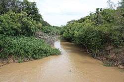 The Comoé River near Folonzo | |
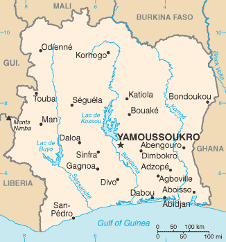 Map of Côte d'Ivoire showing the Komoé River in the eastern part of the country | |
| Location | |
| Country | Burkina Faso, Ivory Coast |
| Physical characteristics | |
| Source | Sikasso Plateau |
| ⁃ location | Bobo-Dioulasso Department, Houet Province, Burkina Faso |
| ⁃ coordinates | 10°58′N 004°30′W |
| ⁃ elevation | 525 m (1,722 ft) |
| Mouth | Grand-Bassam |
⁃ location | Gulf of Guinea, Atlantic Ocean, Ivory Coast |
⁃ coordinates | 5°11′30″N 003°43′20″W |
⁃ elevation | 0 m (0 ft) |
| Length | 759 km (472 mi) |
| Basin features | |
| Tributaries | |
| ⁃ right | Léraba River |
Course
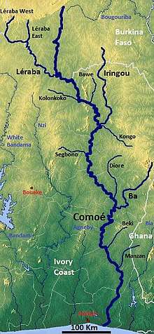
The Komoé River is approximately 759 km long. It rises on the Sikasso Plateau and in the Sindou Hills flowing south over several cataracts with several falls including the "Chutes de la Komoé" and Karifiguela Falls.[3] Upstream of the Karifiguela Falls it is known locally as the Koba River.[3] At 09°42′11″N 004°35′10″W it is joined from the right (west) by the Léraba River, whereafter it flows southeast and forms the border between Burkina Faso and Ivory Coast for some 60 kilometres (37 mi), before it enters Ivory Coast four kilometres southwest of the village of Balanfodougou.
In Ivory Coast, it continues southeast, past the Comoé National Park, forming the border between its Zanzan District and Savanes District. At 09°10′26″N 003°53′33″W it turns south flowing through eastern Ivory Coast and emptying into the far eastern end of the Ébrié Lagoon complex and ultimately the Gulf of Guinea near the port of Grand-Bassam.[2]
Tributaries
- Léraba River at 09°42′11″N 004°35′10″W a right tributary from the west,
- Boin River at 09°12′38″N 003°57′53″W a left tributary from the north in Comoé National Park.
References
- Rupley, Lawrence A.; Bangali, Lamissa; Diamitani, Boureima (2013). "Sikasso Plateau". Historical Dictionary of Burkina Faso. Lanham, Maryland: Scarecrow Press. p. 197. ISBN 978-0-8108-6770-3.
- Mepham, Robert (1991). IUCN Directory of African Wetlands. Pinter Pub. Ltd. ISBN 2-88032-949-3.
- Rupley, Lawrence A.; Bangali, Lamissa; Diamitani, Boureima (2013). "Komoé". Historical Dictionary of Burkina Faso. Lanham, Maryland: Scarecrow Press. p. 114. ISBN 978-0-8108-6770-3.