Kington Magna
Kington Magna is a village and civil parish in the Blackmore Vale in the English county of Dorset, situated about 3.5 miles (5.6 km) south-west of the town of Gillingham, in the North Dorset administrative district.
| Kington Magna | |
|---|---|
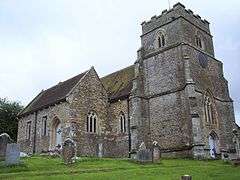 All Saints' Church, Kington Magna | |
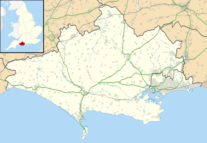 Kington Magna Location within Dorset | |
| Population | 389 [1] |
| OS grid reference | ST765232 |
| District | |
| Shire county | |
| Region | |
| Country | England |
| Sovereign state | United Kingdom |
| Post town | GILLINGHAM |
| Postcode district | SP8 |
| Dialling code | 01747 |
| Police | Dorset |
| Fire | Dorset and Wiltshire |
| Ambulance | South Western |
History
The name Kington Magna means 'great King's Town';[2][3] it derives from cyne- (later cyning) and tūn, Old English for 'royal estate or manor'. The affix magna, Latin for great, was added to distinguish it from Little Kington, a smaller settlement nearby.[4][5] In 1086 in the Domesday Book these were recorded together in three entries as Chintone, which had 27 households and a total taxable value of 13 geld units, and was in the hundred of Gillingham.[6][7] In 1243 it was recorded as Magna Kington.[4] Most of the current buildings in the village are no older than the seventeenth century. In 1851 a Primitive Methodist chapel was built in the village; it was on Chapel Hill, which runs parallel to Church Hill.[5] In 1860 a pottery was established at Bye Farm, north of the main village; it manufactured tiles, drainpipes, bricks, and chimney and flower pots. The parish church of All Saints was restored and enlarged in 1862;[5] most of the building, except for the late 15th-century west tower, was rebuilt.[8] Near the church is a pond which was a medieval fishpond.[5]
Geography
The parish covers about 2,000 acres (810 ha) and, as well as the main village, includes the small settlement of Nyland in the west.[8] The main village is sited on the slopes of a Corallian limestone hill,[9] overlooking the flat Oxford Clay valley of the small River Cale, which drains into the Stour. In 1906 Sir Frederick Treves wrote in his Highways & Byways in Dorset that the village "straggles down hill like a small mountain stream."[2]
Demography
In the 2011 census the parish had 180 dwellings,[10] 169 households and a population of 389.[1]
Transport
The nearest railway station is in Gillingham. Trains run on the Exeter to Waterloo line.
References
- "Area: Kington Magna (Parish). Key Figures for 2011 Census: Key Statistics". Neighbourhood Statistics. Office for National Statistics. Retrieved 8 January 2015.
- Sir Frederick Treves (1906). Highways and Byways in Dorset. Macmillan and Co. Ltd. p. 23.
- North Dorset District Council (c. 1983). North Dorset Official District Guide. Home Publishing Co. Ltd. p. 37.
- Mills, David (2003). A Dictionary of British Place Names. Oxford University Press. ISBN 9780191578472.
- Legg, Rodney; Hannay, Clive (December 2006). "Kington Magna". Dorset Life Magazine. Retrieved 12 January 2015.
- "Place: [Little] Kington and Kington [Magna]". Open Domesday. domesdaymap.co.uk. Archived from the original on 12 January 2015. Retrieved 15 January 2015.
- "Dorse H-R". The Domesday Book Online. domesdaybook.co.uk. Retrieved 11 January 2015.
- "'Kington Magna', in An Inventory of the Historical Monuments in Dorset, Volume 4, North (London, 1972), pp. 41-43". British History Online. University of London. 2014. Retrieved 11 January 2015.
- Ralph Wightman (1983). Portrait of Dorset. Robert Hale Ltd. p. 17. ISBN 0-7090-0844-9.
- "Area: Kington Magna (Parish). Dwellings, Household Spaces and Accommodation Type, 2011 (KS401EW)". Neighbourhood Statistics. Office for National Statistics. Retrieved 1 June 2015.
External links
| Wikimedia Commons has media related to Kington Magna. |
