Kin Kin
Kin Kin is a town and locality in the Shire of Noosa, Queensland, Australia.[1][2]
| Kin Kin Queensland | |||||||||||||||
|---|---|---|---|---|---|---|---|---|---|---|---|---|---|---|---|
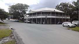 The Country Life Hotel on Main Street, Kin Kin, 2018 | |||||||||||||||
 Kin Kin | |||||||||||||||
| Coordinates | 26.265°S 152.868°E | ||||||||||||||
| Population | 764 (2016 census) | ||||||||||||||
| Postcode(s) | 4571 | ||||||||||||||
| Location | 38 km (24 mi) NW of Noosa Heads | ||||||||||||||
| LGA(s) | Shire of Noosa | ||||||||||||||
| State electorate(s) | Noosa | ||||||||||||||
| Federal Division(s) | Wide Bay | ||||||||||||||
| |||||||||||||||
Geography
Kin Kin lies between Pomona to the south, and Gympie to the north, in South East Queensland. The town is a hub for recreational activities related to nearby Lake Cootharaba and the Great Sandy National Park.[3] Kin Kin is in the Noosa Biosphere, Queensland's first UNESCO Biosphere.[4]
In the west of Kin Kin is Woondum National Park and Woondum Forest Reserve. The hills and mountains in this area are covered by eucalypt forest and rainforest.[5]
History
There has long been debate over the origin of the name Kin Kin. It is most widely believed to mean "plenty black ants" after the small black ants very common in the area.[3][6][7] This is reflected in the local school newsletter "Kin Kin ANTics" and the large ant sculpture outside the Kin Kin General store, home of Black Ant Gourmet. Some sources suggest the name comes from the Aboriginal kauin kauin meaning red soil.[8][9]
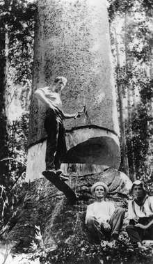
Timber-getters moved into the area in the late 1870s.[3] Until the mid-1970s Kin Kin was predominantly a smallcrop and dairy farming community, from then on land and farm usage started to change and there was a decline in production farms. Early deforestation and clearing of land led to small produce and dairy farming from the early 1900s. The banana industry boomed in the years after World War 1, but experienced a significant decline in the 1930s as prices fell. Beans and Zucchini were major crops for many years, but smallcropping declined from the 1980s and is now undertaken on a limited basis.
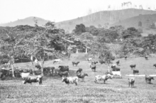
The butter factory was closed in 1937[3] but the sawmill still survives. Deregulation of the milk industry led to the exit of all but a handful of family dairy farms. The last farms (in order of closure, Davis, Ferris, and Shepperson) had closed by 2012. Nowadays many original farms have been subdivided into small hobby farms, some growing fruit trees, and many carrying horses or beef cattle. Today Kin Kin boasts health retreats, accommodation, small businesses, artists and bush foods.
The family of William D. Francis one of Queensland's pioneering botanists owned land in the area, and many native trees first identified by him are found in the area.[10]
From 1980 the "Great Kin Kin Horse Race" and associated Carnival was held annually on a hilly 3 km course over the southern end of the Wahpunga Range, starting and finishing at the showgrounds behind the Country Life Hotel. After peaking in popularity in the late 80s and early 90s, the race was eventually discontinued, with the last Carnival being held in 2004.[11] The horse ride has been revived as an annual social ride covering 25 km on the Noosa Trail Network from the Kin Kin Showgrounds to Tablelands Lookout near Cooran and back.[12]
On 14 August 1971, a tornado passed through the town killing three people.[13] Another tornado hit on 28 February 1985, destroying the Butter Factory and causing widespread property damage.[14][15][16] On 4 November 1994 a severe storm produced large hail and a tornado which damaged or completely destroyed several buildings.[17]
In 2007, a plan to develop a $400 million eco-tourism resort east of Kin Kin was rejected by the Government of Queensland on the grounds that the development was not part of the regional planning document.[18]
Although currently and historically within the Shire of Noosa, between 2008 and 2013 the Shire of Noosa (and hence Kin Kin) was within the Sunshine Coast Region) until 2014 when the shire was re-instated following a vote by the residents.[19][20]
In early April 2009 the town was hit by severe flooding [21] from Kin Kin Creek, a tributary of the Noosa River.
At the 2011 census Kin Kin had a population of 694.[22]
Heritage listings
Kin Kin has a number of heritage-listed sites, including:
- Bowman Street: Kin Kin Masonic Lodge [23]
- Grady Street: St Luke's Anglican Church [23]
- Main Street: Kin Kin State School [23]
- Main Street: Kin Kin Memorial School of Arts [23]
- Main Street: Former Post Office [23]
- Main Street: Former ES&A Bank and residence [23]
- Corner Main Street & Wahpunga Road: Country Life Hotel [23]
- Pomona Kin Kin Road: Kin Kin Junction Uniting Church (now a private residence)[23]
- 1 Sister Tree Creek Road: Kin Kin Sawmill [24]
Education
Children from Kin Kin[25] attend a school in Kin Kin village up to grade 6. Secondary school students attend Noosa District State High School: grades 7—8 attend the Pomona campus, and grades 9—12 attend the Cooroy campus.
Amenities
The Shire of Noosa operates a mobile library service on a weekly schedule at the Kin Kin school.[26]
There are public toilets and a playground in the park next to the Memorial School of Arts Hall, and public toilets, a barbecue, and shelter at Wahpunga School Park.
The Kin Kin Tennis Courts are located behind the Memorial School of Arts Hall.
There is a skate park and public camping available on the oval behind the Country Life Hotel.
The Kin Kin Arboretum is located 2.5 km south of the village.
References
- "Kin Kin - town in Shire of Noosa (entry 18157)". Queensland Place Names. Queensland Government. Retrieved 3 July 2017.
- "Kin Kin - locality in Shire of Noosa (entry 48703)". Queensland Place Names. Queensland Government. Retrieved 3 July 2017.
- Environmental Protection Agency (Queensland) (2000). Heritage Trails of the Great South East. State of Queensland. p. 147. ISBN 0-7345-1008-X.
- Noosa Biosphere Archived 20 February 2011 at the Wayback Machine. Retrieved 26 August 2012.
- "About Woondum". Department of National Parks, Recreation, Sport and Racing. 7 January 2013. Archived from the original on 19 October 2014. Retrieved 14 October 2014.
- Noosa Attractions and Places Archived 12 December 2006 at the Wayback Machine. 7 January 2007.
- "MEANING OF KIN KIN AND COOTHARABA". Brisbane Courier (Qld. : 1864 - 1933). 11 March 1933. p. 11. Retrieved 15 February 2018.
- South East Queensland - Place Names Archived 22 August 2006 at the Wayback Machine. 19 December 2006.
- Noosa Community Guide 2005 Part D Archived 24 July 2008 at the Wayback Machine. 19 December 2006.
- Noosa Shire Historical Cultural Heritage Kin Kin July 2002 Archived 29 August 2007 at the Wayback Machine. 2 January 2007.
- "2004 Kin Kin Carnival".
- "Extracts from the Sunshine Coast Daily 30 years ago today:". pressreader.com. 27 October 2018. Archived from the original on 23 September 2019. Retrieved 23 September 2019.
- "Drought, Dust and Deluge: Severe Storms: Tornadoes". Bureau of Meteorology. Archived from the original on 24 March 2012. Retrieved 3 February 2013.
- "Our big bashes: storms that smashed the Coast". Sunshine Coast Daily. Archived from the original on 26 January 2018. Retrieved 25 January 2018.
- "Life's good in the country". Sunshine Coast Daily. Archived from the original on 14 February 2020. Retrieved 14 February 2020.
- "ARCHIVE: Queensland Severe Thunderstorms, 1850 – 2007" (PDF). Green Cross Australia. Archived (PDF) from the original on 14 February 2020. Retrieved 14 February 2020.
- "Brisbane Storm Chasers- Tornadoes in SE Qld". Archived from the original on 28 September 2018. Retrieved 13 October 2018.
- "Anger over Kin Kin development rejection". ABC News. Australian Broadcasting Corporation. 18 June 2007. Retrieved 24 August 2012.
- "About Noosa". Noosa Shire Council. Archived from the original on 29 February 2020. Retrieved 3 March 2020.
- "De-amalgamation in Queensland | Local Government Commission". www.lgc.govt.nz. Archived from the original on 2 March 2020. Retrieved 2 March 2020.
- Robert Blackmore & Sara Hicks (8 April 2009). "Flood damage and isolation in Kin Kin". ABC Sunshine Coast. Australian Broadcasting Corporation. Archived from the original on 27 December 2014. Retrieved 24 August 2012.
- Australian Bureau of Statistics (31 October 2012). "Kin Kin (Noosa Shire) (State Suburb)". 2011 Census QuickStats. Retrieved 2 February 2013.

- "SCHEDULE 3—HERITAGE SITES" (PDF). Noosa Shire Council. October 2016. Archived from the original (PDF) on 9 April 2017. Retrieved 28 February 2018.
- "Kin Kin Sawmill (entry 602686)". Queensland Heritage Register. Queensland Heritage Council. Retrieved 14 July 2013.
- Kin Kin State School Archived 16 February 2011 at the Wayback Machine. Department of Education and Training. Retrieved 26 August 2012.
- "Noosa Mobile Library - Mobile Stops - Noosa Mobile Hours". Shire of Noosa. Archived from the original on 30 January 2018. Retrieved 19 January 2018.
Further reading
- Page, Ruth (1970), The history of Pomona, Cooran, Kin Kin, Cootharaba, Skyrings Creek (PDF), archived (PDF) from the original on 14 November 2019
External links
| Wikimedia Commons has media related to Kin Kin, Queensland. |