Kem, Russia
Kem (Russian: Кемь; Finnish and Karelian: Kemi) is a historic town and the administrative center of Kemsky District of the Republic of Karelia, Russia, located on the shores of the White Sea where the Kem River enters it, on the railroad leading from Petrozavodsk to Murmansk. Population: 13,051 (2010 Census);[2] 14,620 (2002 Census);[8] 18,522 (1989 Census).[9]
Kem Кемь | |
|---|---|
Town[1] | |
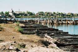 Kem and its harbor | |
_(1788).png) Coat of arms | |
Location of Kem 
| |
 Kem Location of Kem 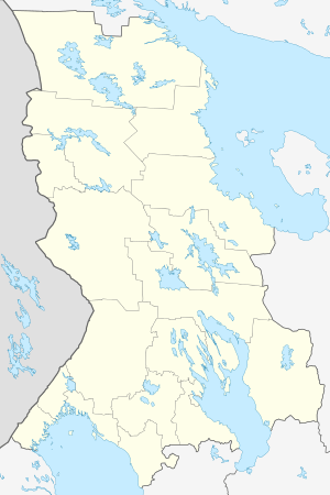 Kem Kem (Karelia) | |
| Coordinates: 64°57′N 34°35′E | |
| Country | Russia |
| Federal subject | Republic of Karelia[1] |
| Administrative district | Kemsky District[1] |
| First mentioned | 1450 |
| Town status since | 1785 |
| Area | |
| • Total | 21 km2 (8 sq mi) |
| Elevation | 10 m (30 ft) |
| Population | |
| • Total | 13,051 |
| • Estimate (2018)[3] | 11,182 (-14.3%) |
| • Density | 620/km2 (1,600/sq mi) |
| • Capital of | Kemsky District[1] |
| • Municipal district | Kemsky Municipal District[4] |
| • Urban settlement | Kemskoye Urban Settlement[4] |
| • Capital of | Kemsky Municipal District[5], Kemskoye Urban Settlement[4] |
| Time zone | UTC+3 (MSK |
| Postal code(s)[7] | 18661x |
| Dialing code(s) | +7 81458 |
| OKTMO ID | 86612101001 |
| Website | kem |
History
![]()
![]()
![]()
![]()
![]()
![]()
Kem was first mentioned as a demesne of the Novgorod posadnik Marfa Boretskaya in 1450, when she donated it to the Solovetsky Monastery (situated in the White Sea several kilometers off shore). In 1657, a wooden fort was erected there. Also wooden is the town's remarkable cathedral, built in 1711–1717. It is a fine example of the tented roof-construction so popular in old Russian architecture. The cathedral's iconostasis features precious 17th-century icons from Novgorod.
Town status was granted to Kem in 1785.

On April 10, 1918 the town was reached by Finnish troops during the Viena expedition in an attempt to join White Karelia to Finland.
In 1926–1939, Kem was used as departure place for boats headed to Solovetsky Islands carrying political prisoners. During the Cold War, the town was the site of the Poduzhemye air base, a key interceptor aircraft airfield covering Karelia.
Climate
Kem has a subarctic climate (Köppen climate classification: Dfc).[10] It has a significant maritime influence compared with areas further east in the country with cool summers and less severe winters. The temperature regime has more in common with maritime areas on similar parallels in the Nordic countries to the west. It is some way above polar climate due to the milder summers with three months above 10 °C (50 °F) in mean temperature.[11]
| Climate data for Kem | |||||||||||||
|---|---|---|---|---|---|---|---|---|---|---|---|---|---|
| Month | Jan | Feb | Mar | Apr | May | Jun | Jul | Aug | Sep | Oct | Nov | Dec | Year |
| Record high °C (°F) | 8.7 (47.7) |
6.5 (43.7) |
12.0 (53.6) |
19.6 (67.3) |
29.2 (84.6) |
31.1 (88.0) |
32.6 (90.7) |
31.8 (89.2) |
25.6 (78.1) |
16.6 (61.9) |
11.4 (52.5) |
6.9 (44.4) |
32.6 (90.7) |
| Average high °C (°F) | −6.9 (19.6) |
−6.4 (20.5) |
−1.6 (29.1) |
3.4 (38.1) |
9.1 (48.4) |
14.9 (58.8) |
18.5 (65.3) |
16.3 (61.3) |
11.8 (53.2) |
5.4 (41.7) |
−0.8 (30.6) |
−4.4 (24.1) |
4.9 (40.8) |
| Daily mean °C (°F) | −10.3 (13.5) |
−9.9 (14.2) |
−5.3 (22.5) |
−0.3 (31.5) |
5.1 (41.2) |
10.9 (51.6) |
14.5 (58.1) |
13.0 (55.4) |
8.7 (47.7) |
3.1 (37.6) |
−3.3 (26.1) |
−7.6 (18.3) |
1.6 (34.9) |
| Average low °C (°F) | −14.1 (6.6) |
−13.5 (7.7) |
−9.1 (15.6) |
−4.1 (24.6) |
1.7 (35.1) |
7.1 (44.8) |
11.2 (52.2) |
9.8 (49.6) |
5.9 (42.6) |
0.7 (33.3) |
−5.9 (21.4) |
−10.9 (12.4) |
−1.8 (28.8) |
| Record low °C (°F) | −40.3 (−40.5) |
−35.1 (−31.2) |
−32.5 (−26.5) |
−25.8 (−14.4) |
−12.2 (10.0) |
−2.6 (27.3) |
2.0 (35.6) |
0.6 (33.1) |
−4.1 (24.6) |
−17.0 (1.4) |
−26.3 (−15.3) |
−34.2 (−29.6) |
−40.3 (−40.5) |
| Average precipitation mm (inches) | 26 (1.0) |
19 (0.7) |
23 (0.9) |
26 (1.0) |
48 (1.9) |
56 (2.2) |
59 (2.3) |
63 (2.5) |
54 (2.1) |
52 (2.0) |
41 (1.6) |
31 (1.2) |
498 (19.6) |
| Source: Pogoda.ru.net | |||||||||||||
Administrative and municipal status
Within the framework of administrative divisions, Kem serves as the administrative center of Kemsky District, to which it is directly subordinated.[1] As a municipal division, the town of Kem, together with three rural localities, is incorporated within Kemsky Municipal District as Kemskoye Urban Settlement.[4]
In popular culture
Kem was the site of The Island (2006 film).
References
Notes
- Law #871-RZK
- Russian Federal State Statistics Service (2011). "Всероссийская перепись населения 2010 года. Том 1" [2010 All-Russian Population Census, vol. 1]. Всероссийская перепись населения 2010 года [2010 All-Russia Population Census] (in Russian). Federal State Statistics Service.
- "26. Численность постоянного населения Российской Федерации по муниципальным образованиям на 1 января 2018 года". Federal State Statistics Service. Retrieved January 23, 2019.
- Law #813-RZK
- Law #825-ZRK
- "Об исчислении времени". Официальный интернет-портал правовой информации (in Russian). June 3, 2011. Retrieved January 19, 2019.
- Почта России. Информационно-вычислительный центр ОАСУ РПО. (Russian Post). Поиск объектов почтовой связи (Postal Objects Search) (in Russian)
- Russian Federal State Statistics Service (May 21, 2004). "Численность населения России, субъектов Российской Федерации в составе федеральных округов, районов, городских поселений, сельских населённых пунктов – районных центров и сельских населённых пунктов с населением 3 тысячи и более человек" [Population of Russia, Its Federal Districts, Federal Subjects, Districts, Urban Localities, Rural Localities—Administrative Centers, and Rural Localities with Population of Over 3,000] (XLS). Всероссийская перепись населения 2002 года [All-Russia Population Census of 2002] (in Russian).
- "Всесоюзная перепись населения 1989 г. Численность наличного населения союзных и автономных республик, автономных областей и округов, краёв, областей, районов, городских поселений и сёл-райцентров" [All Union Population Census of 1989: Present Population of Union and Autonomous Republics, Autonomous Oblasts and Okrugs, Krais, Oblasts, Districts, Urban Settlements, and Villages Serving as District Administrative Centers]. Всесоюзная перепись населения 1989 года [All-Union Population Census of 1989] (in Russian). Институт демографии Национального исследовательского университета: Высшая школа экономики [Institute of Demography at the National Research University: Higher School of Economics]. 1989 – via Demoscope Weekly.
- "Kem', Russia Climate Summary". Weatherbase. Retrieved March 22, 2015.
- "Kem', Russia Climate Summary". Weatherbase. Retrieved March 22, 2015.
Sources
- Законодательное Собрание Республики Карелия. Закон №871-ЗРК от 29 апреля 2005 г. «Об административно-территориальном устройстве Республики Карелия», в ред. Закона №1895-ЗРK от 2 июня 2015 г. «О внесении изменения статью 9 Закона Республики Карелия "Об административно-территориальном устройстве Республики Карелия"». Вступил в силу со дня официального опубликования. Опубликован: газета "Карелия", №48, 7 мая 2005 г. (Legislative Assembly of the Republic of Karelia. Law #871-ZRK of April 29, 2005 On the Administrative-Territorial Structure of the Republic of Karelia, as amended by the Law #1895-ZRK of June 2, 2015 On Amending Article 9 of the Law of the Republic of Karelia "On the Administrative-Territorial Structure of the Republic of Karelia". Effective as of the official publication date.).
- Законодательное Собрание Республики Карелия. Закон №813-ЗРК от 1 ноября 2004 г. «О городских, сельских поселениях в Республике Карелия», в ред. Закона №1694-ЗРK от 2 апреля 2013 г. «О преобразовании муниципальных образований "Нюхчинское сельское поселение" и "Сумпосадское сельское поселение" Беломорского муниципального района и внесении изменений в некоторые законодательные акты Республики Карелия». Вступил в силу по истечении десяти дней со дня официального опубликования. Опубликован: газета "Карелия", №124, 126, 129, 132, 135, 136, 139, 4 ноября — 9 декабря 2004 г. (Legislative Assembly of the Republic of Karelia. Law #813-ZRK of November 1, 2004 On the Urban, Rural Settlements in the Republic of Karelia, as amended by the Law #1694-ZRK of April 2, 2013 On the Transformation of the Municipal Formations of "Nyukhchinskoye Rural Settlement" and "Sumposadskoye Rural Settlement" of Belomorsky Municipal District of the Republic of Karelia and on Amending Various Legislative Acts of the Republic of Karelia. Effective as of the day which is ten days after the day of the official publication.).
- Законодательное Собрание Республики Карелия. Закон №825-ЗРК от 1 декабря 2004 г. «О муниципальных районах в Республике Карелия», в ред. Закона №1694-ЗРK от 2 апреля 2013 г. «О преобразовании муниципальных образований "Нюхчинское сельское поселение" и "Сумпосадское сельское поселение" Беломорского муниципального района и внесении изменений в некоторые законодательные акты Республики Карелия». Вступил в силу по истечении десяти дней со дня официального опубликования. Опубликован: газета "Карелия", №141, 16 декабря 2004 г. (Legislative Assembly of the Republic of Karelia. Law #825-ZRK of December 1, 2004 On the Municipal Districts in the Republic of Karelia, as amended by the Law #1694-ZRK of April 2, 2013 On the Transformation of the Municipal Formations of "Nyukhchinskoye Rural Settlement" and "Sumposadskoye Rural Settlement" of Belomorsky Municipal District of the Republic of Karelia and on Amending Various Legislative Acts of the Republic of Karelia. Effective as of the day which is ten days after the day of the official publication.).
External links
- Unofficial website of Kem (in Russian)
| Administrative districts | ||
|---|---|---|
| Cities and towns | ||
| Urban-type settlements | ||
| Key locations |  | |
|---|---|---|
| Monasteries | ||