Kefalari (Argolis)
Kefalari Greek:Κεφαλάρι ‚spring‘ (gushing abundant water)) is the name of the community Kefalari (Argolis). Several Greek villages in mountainous areas, where spring water is abundant, have similar names with some kind of describing supplements. This article is about the community at the northern boarder of the “Plain of Argos”, Peloponnese, at the Argolic Gulf. The village developed around a large geologically significant karst spring. In the mythology and the life of ancient Greeks this spring was of importance and today it is a place of orthodox pilgrimage.
Geography
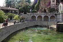
Kefalari is a small community with 577 residents in the municipality of Argos-Mykines on the peninsula Peloponnese. Argos, the next larger city and seat of the municipality, is ca. six km from Kefalari. Here, where the carbonate mountains end and the fertile “Plain of Argos” begins, large quantities of water, so far running in subterranean waterways, emerge from a large karst spring. The karst water runs in river Erasinos (in ancient times a river god[1]) towards the sea, where, after ca. five km it ends up in the village Nea Kios at the Argolic Gulf. The Kefalari spring's outlet is framed by walls and rows of Platanus trees.
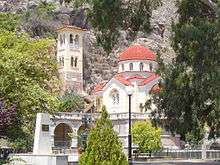
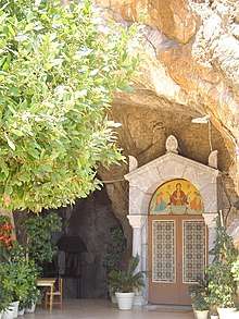
Rivers and springs as locations of fresh sweet water played a vital role in Greece at all times – in ancient Greek mythology these locations were the manifestation of gods. Well kept styled fountains as central points and sources of community life and identification are still vivid symbols especially in rural tradition throughout Greece. In Kefalari there is a cave of some 60 m above the karst spring,[2] today decorated and dedicated to the Blessed Virgin Mary. Cave, spring („Zoodochos Pigi“) and an orthodox church became a center for worship of the „Panagia Kefalariotissa“. The church with foundations dating back to Roman emperors, was reconstructed at its present dominating location in 1835. Today Kefalari is a place of pilgrimage, especially for the nearby Nea Kios.
About two km west of the village there is the archeological site Pyramid of Kefalari. There are two ancient sites with remnants of a pyramidal stone construction in Greece, both in Argolis. The ruin “Pyramid of Kefalari” with its base of 7 to 9 m can hardly be compared with the gigantic pyramids in Egypt.
Geology and Hydrogeology
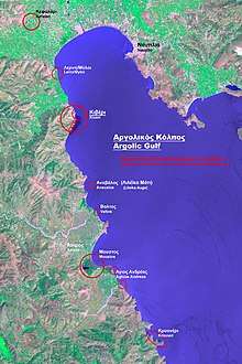
Most of the water of this karst spring, as well as of other springs close to or directly at the Argolic Gulf has its origin from ponors (in Greece Καταβόθρες) in poljes of the arcadic highland (big Tripoli basin, Argon Pedion[3]) and of the highlands of Corinthia and Argolis (Lake Stymphalia, Alea, Argolis/Skoteini). Common knowledge in hydrogeology says, karst waters of mountainous karst land emerge to the surface right at boarders where there are impermeable sediments - in this case: the fertile “Plain of Argos”. The sediments grew up by fluvial sedimentation and/or a falling water level of the Argolic Gulf (in geological periods).
An elaborate geological/hydrogeological study carried out by an international group of scientists analyzed hydrogeological structures of extended terrains of Acadia, Corinthia and Argolis. An enormous number of katavothres (ponors) in closed basins of highlands, hydro-tectonical structures of fault_(geology)|faults]] were mapped, which allow subterranean waterways directed towards the Argolic Gulf. The distribution of the karst waters flowing to various springs at the Argolic Gulf was mapped in detail and backed up by numerous chemical and physical dye tracingtests in 1983 and 1984.[4]
As rivers and springs always played a vital role for ancient Greeks – mythologically and in their everyday life – it is not surprising, that a water connection between Lake Stymphalia and spring Kefalari was already assumed in ancient times.[5] According to the above-mentioned scientific study of Morfis etal dye tracing tests for Kefalari confirmed a water connection coming from the polje of Skafidia (a small polje belonging to the Feneos-Corintia-Complex and a water connection coming from the Argolis polje Alea/Skoteini[6] to Kefalari.
While the submarine karst spring at Kiveri (with its largest discharge at the Argolic Gulf) flows permanently, Kefalari's spring discharge varies between very much and nill (in the dry period). According to the Morfis study the cave above the spring “corresponds to a former karst level”.[7] After collecting the water of the Kiveri spring by a wall cage in1972[8] and finishing a ca. 30 km long concreate irrigation channel for the “Plain of Argos” Kefalari's spring got “additional water from the spring Kiveri. Until February 1983 the spring water also served the drinking water supply in Argos. This is no longer possible, because of the bad water quality.”[9]
Literature
- William Smith: Dictionary of Greek and Roman Geography, London (Walton and Maberly) 1854
- Richard Speich: Südgriechenland. Kunst- und Reiseführer, Band 2 Peloponnes, Stuttgart u. a. (Kohlhammer) 1980, ISBN 3-17-005395-7, S. 119
- Lambert Schneider: Peloponnes. Mykenische Paläste, antike Heiligtümer und venezianische Kastelle in Griechenlands Süden, Köln (DuMont) 2001, ISBN 3-7701-4599-2, S. 178
- Morfis, A. (Athens), Zojer, H. (Graz). Karst Hydrogeology of the Central and Eastern Peloponnesus (Greece). Steirische Beiträge zur Hydrogeologie 37/38. 301 pages, Graz 1986
External links
| Wikimedia Commons has media related to Karst springs in Greece. |
References
- See Erasinos
- see the chapter below, “Geology and Hydrogeology” for the cave’s geological origin
- See Argon Pedion
- Morfis et al., pp. 24-33 and pp. 276. See Literature
- ”The ancient Greeks believed that the waters of Stymphalia Lake were coming here.(…) Tourist brochure of the Prefecture of Argolis, 2004”, cited by Greek Travel Pages. See Weblinks
- Morfis etal, graphik p. 281
- Morfis etal, p. 199
- See the photo in the article Kiveri
- Morfis etal, p. 200