Alea, Argolis
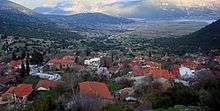
Alea (Greek: Αλέα, before 1928: Μπουγιάτι – Bougiati)[2] is a village and a former community in Argolis, Peloponnese, Greece. Since the 2011 local government reform it is part of the municipality Argos-Mykines, of which it is a municipal unit.[3] The municipal unit has an area of 143.206 km2.[4] In 2011 its population was 103 for the village and 660 for the municipal unit. The seat of the community was Skoteini. Alea is situated in the mountainous northwestern part of Argolis, 5 km southeast of Kandila, 12 km northwest of Lyrkeia, 14 km northeast of Levidi and 27 km north of Tripoli. The Greek National Road 66 (Levidi – Nemea) passes near Skoteini.
Alea Αλέα | |
|---|---|
 Alea Location within the regional unit 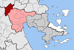 | |
| Coordinates: 37°45′N 22°26′E | |
| Country | Greece |
| Administrative region | Peloponnese |
| Regional unit | Argolis |
| Municipality | Argos-Mykines |
| • Municipal unit | 143.2 km2 (55.3 sq mi) |
| Population (2011)[1] | |
| • Municipal unit | 660 |
| • Municipal unit density | 4.6/km2 (12/sq mi) |
| Community | |
| • Population | 103 (2011) |
| Time zone | UTC+2 (EET) |
| • Summer (DST) | UTC+3 (EEST) |
| Vehicle registration | AP |
Subdivisions
The municipal unit Alea is subdivided into the following communities (constituent villages in brackets):
- Agios Nikolaos (Agios Nikolaos, Exochi, Platani)
- Alea
- Frousiouna
- Skoteini
Population
| Year | Village population | Community population |
|---|---|---|
| 1981 | 170 | – |
| 1991 | 115 | 809 |
| 2001 | 146 | 793 |
| 2011 | 103 | 660 |
History
Alea was an ancient city of Arcadia, founded by the mythical king Aleus, a son of Apheidas. It was situated near Stymphalos. The city had temples of Artemis of Ephesus, Athena Alea and Dionysus. Every other year the Skiereia, a celebration for the god Dionysus, were celebrated.[5] Traces of ancient buildings have been found near the modern village.
See also
References
- "Απογραφή Πληθυσμού - Κατοικιών 2011. ΜΟΝΙΜΟΣ Πληθυσμός" (in Greek). Hellenic Statistical Authority.
- Name changes of settlements in Greece
- Kallikratis law Greece Ministry of Interior (in Greek)
- "Population & housing census 2001 (incl. area and average elevation)" (PDF) (in Greek). National Statistical Service of Greece. Archived from the original (PDF) on 2015-09-21.
- Pausanias Description of Greece 8.23.1