Kearns, Utah
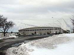
Kearns (/kɜːrnz/ kurnz) is a metro township in Salt Lake County, Utah, United States. Named after Utah's U.S. Senator Thomas Kearns, it had a population of 35,731 at the 2010 Census.[3] This was a 6.2 percent increase over the 2000 figure of 33,659. Kearns is home to the Utah Olympic Oval, an indoor speed skating oval built for the 2002 Winter Olympics.
Kearns, Utah | |
|---|---|
Metro Township | |
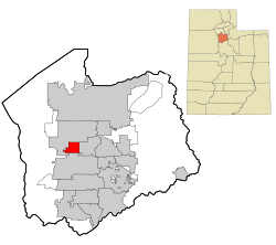 Location in Salt Lake County and the state of Utah. | |
| Coordinates: 40°39′11″N 112°0′24″W | |
| Country | United States |
| State | Utah |
| County | Salt Lake |
| Founded | 1 May, 1942 |
| Granted Township Status | 1 June, 2002 |
| Incorporated as a Metro Township | January, 2017 |
| Named for | Thomas Kearns |
| Government | |
| • Chair/Mayor | Kelly Bush |
| Area | |
| • Total | 4.8 sq mi (12.5 km2) |
| • Land | 4.8 sq mi (12.5 km2) |
| • Water | 0.0 sq mi (0.0 km2) |
| Elevation | 4,528 ft (1,380 m) |
| Population (2010) | |
| • Total | 35,731 |
| • Density | 6,994.1/sq mi (2,700.4/km2) |
| Time zone | UTC-7 (Mountain (MST)) |
| • Summer (DST) | UTC-6 (MDT) |
| ZIP code | 84118 |
| Area code(s) | 385, 801 |
| FIPS code | 49-40470[1] |
| GNIS feature ID | 1429290[2] |
| Website | https://www.kmtutah.org/ |
History
- See also: Kearns Army Airfield for information about the military use of the facility
- 1942-1946

Kearns came into existence 1 May 1942 as a World War II United States Army Air Forces training facility known as Kearns Army Air Base (also known as Kearns Center; redesignated: Camp Kearns, 1 January 1944). Construction of the base involved building airplane runways and hangars, with several taxiways and a large parking apron and a control tower. Several hundred buildings were also constructed and quickly assembled. Most base buildings, not meant for long-term use, were constructed of temporary or semi-permanent materials. Most support buildings sat on concrete foundations but were of frame construction clad in little more than plywood and tarpaper. The thousands of soldiers and airmen stationed there temporarily made the base one of the largest cities in the state. On 15 August 1946 the Air Force deactivated the base, and turned the facility over to the State of Utah. The presence of roads and other infrastructure made the area attractive to developers. Houses and business sprang up rapidly on what had just a few years earlier been farmland. A theater for "colored personnel" became part of Kearns Junior High School. A base chapel is now part of Our Lady of Perpetual Help Catholic Church. The base train station is a day-care center. A cannon that had stood next to the headquarters' flagpole stood for many years at the corner of 40th West and 54th South. The airfield part of Kearns Army Air Base today is known as South Valley Regional Airport.[4]
1950's-2006
Kearns in the mid to late 1900s saw rapid growth in the former air base. By the 1970s and 1980s suburban development had begun expanding west of the railroad to 5600 west. In 2002 the winter Olympics brought the construction of the Olympic oval at the Oquirrh park before the Olympic oval was built the spot it was built on used to be a running track for Oquirrh park then the Olympic oval was built there for the Olympics and is used today as a tourist attraction and a recreation spot. The last major housing areas constructed in Kearns was a area between 5600 west and 6200 south built by reliance homes from 2002-2006.
2006-present
In 2015 the township of Kearns voted to incorporate as a metro township, a new form of local government that allowed it to elect a council and mayor. The following year five council members were elected from districts and took office in 2017. In 2019 and 2020 more housing was built around Oquirrh park. The Kearns library will be finished by the fall of 2020. Every year in late July and early August there is a parade in Kearns.
Geography
According to the United States Census Bureau, the CDP has a total area of 4.8 square miles (12 km2), all of it land and a small irrigation canal.
Kearns lies on the western side of the salt lake valley and West bench. the majority of the township lies on the lake bed of the Provo episode of lake Bonneville. And all of Kearns lies on the Bonneville lake bed.
The area where Kearns is situated on a natural formation called the Kearns-Benion hill this is a hill that rises about 100 feet above the valley. The hill runs in a northwest direction from the Jordan river to Bacchus hill in the Oquirrh mountains.
Climate
This climatic region is typified by large seasonal temperature differences, with warm to hot (usually dry) summers and cold (sometimes severely cold) winters. According to the Köppen Climate Classification system, Kearns has a humid continental climate, abbreviated "Dfb" on climate maps.[5]
Demographics
| Historical population | |||
|---|---|---|---|
| Census | Pop. | %± | |
| 1960 | 17,172 | — | |
| 1970 | 17,071 | −0.6% | |
| 1980 | 21,353 | 25.1% | |
| 1990 | 28,374 | 32.9% | |
| 2000 | 33,659 | 18.6% | |
| 2010 | 35,731 | 6.2% | |
| source:[6] | |||
According to estimates from the Kem C. Gardner Policy Institute of the University of Utah[7], as of 2015, there were 36,530 people in Kearns. The racial makeup of the county was 60.21% non-Hispanic White, 0.89% Black, 0.79% Native American, 2.07% Asian, 1.95% Pacific Islander, and 2.41% from two or more races. 31.68% of the population were Hispanic or Latino of any race.
As of the census[1] of 2010, there were 35,731 people, 9,789 households, and 9,209 families residing in the CDP. The population density was 7,444 people per square mile (4,625.5/km²). There were 10,169 housing units at an average density of 2,118.5/sq mi (1,316.4/km²). The racial makeup of the CDP was 70.29% White, 1.39% African American, 1.44% Native American, 2.08% Asian, 2.64% Pacific Islander, 18.72% from other races, and 3.45% from two or more races. Hispanic or Latino of any race were 32.83% of the population.
There were 9,789 households out of which 54.1% had children under the age of 18 living with them, 67.3% were married couples living together, 13.1% had a female householder with no husband present, and 13.8% were non-families. 10.5% of all households were made up of individuals and 3.7% had someone living alone who was 65 years of age or older. The average household size was 3.65 and the average family size was 3.88.
In the CDP, the population was spread out with 37.2% under the age of 18, 11.2% from 18 to 24, 32.0% from 25 to 44, 13.4% from 45 to 64, and 6.3% who were 65 years of age or older. The median age was 26 years. For every 100 females, there were 102.5 males. For every 100 females age 18 and over, there were 100.2 males.
The median income for a household in the CDP was $45,711, and the median income for a family was $46,598. Males had a median income of $31,444 versus $22,838 for females. The per capita income for the CDP was $14,110. About 5.1% of families and 7.1% of the population were below the poverty line, including 9.3% of those under age 18 and 6.5% of those age 65 or over.
References
- "U.S. Census website". United States Census Bureau. Retrieved 2008-01-31.
- "US Board on Geographic Names". United States Geological Survey. 2007-10-25. Retrieved 2008-01-31.
- Utah Trend Report 2: State and Complete Places (Sub-state 2010 Census Data). Archived 2012-07-19 at Archive.today Missouri Census Data Center. Accessed 2011-02-26.
- Manning, Thomas A. (2005), History of Air Education and Training Command, 1942–2002. Office of History and Research, Headquarters, AETC, Randolph AFB, Texas ASIN: B000NYX3PC
- Climate Summary for Kearns, Utah
- "CENSUS OF POPULATION AND HOUSING (1790–2000)". U.S. Census Bureau. Retrieved 31 July 2010.
- "Salt Lake City Data Book 2017" (PDF). Kem C. Gardner Policy Institute. Retrieved April 16, 2018.
External links
| Wikimedia Commons has media related to Kearns, Utah. |
- Kearns Metro Township Website
- Chamber of Commerce/Tourism website
- The Oquirrh Times newspaper - West Valley News, Magna Times & Kearns Post Newspapers combined
Places adjacent to Kearns, Utah | |
|---|---|
Municipalities and communities of Salt Lake County, Utah, United States | ||
|---|---|---|
| Cities |  Map of Utah highlighting Salt Lake County | |
| Towns | ||
| Metro Townships | ||
| CDPs | ||
| Unincorporated communities | ||
| Ghost towns |
| |
| Footnotes | ‡This populated place also has portions in an adjacent county or counties | |
| Authority control |
|
|---|