Kate Shelley High Bridge
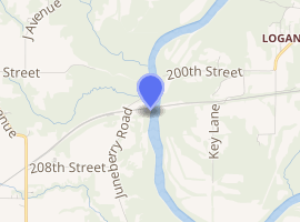
The Kate Shelley High Bridge, officially called the Boone Viaduct when it was completed in 1901, is one of the highest and longest double-track railroad bridges in the United States. It is located approximately 3 miles (4.8 km) west of Boone, Iowa.
Kate Shelley High Bridge | |
|---|---|
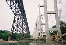 original steel on the left; new concrete/steel on the right | |
| Coordinates | 42°03′32″N 93°58′12″W |
| Carries | Freight trains |
| Crosses | Des Moines River |
| Locale | Boone, Iowa, United States |
| Maintained by | Union Pacific |
| Characteristics | |
| Material | Steel |
| Total length | 2,685 ft (818 m) |
| Height | 185 ft (56 m) |
| Piers in water | 8-16 |
| History | |
| Designer | George S. Morison |
| Construction start | 1899 |
| Construction end | 1901 |
| Closed | 2009 |
Boone Viaduct | |
  | |
| Architect | George S. Morison |
| NRHP reference No. | 78001207 [1] |
| Added to NRHP | November 17, 1978 |
| |
It was nicknamed for the Iowa railroad heroine, Kate Shelley, also spelled Shelly. In 1881, when she was 17 years old, Kate Shelley risked her life to warn a passenger train by crossing the Des Moines River Bridge near Moingona at night, during a thunderstorm. Her goal was to warn the passenger train that the next bridge was out. That train had already been stopped. She then led rescuers to two men still in the swollen, flooded Honey Creek near her house, and they were saved. Her bravery was heralded in many newspapers.[2]
The bridge was designed by George S. Morison for the Chicago & North Western Railway and was constructed from 1899 to 1901.[3] It stands 185 feet (56 m) above the Des Moines River and is 2,685 feet (818 m) long. The bridge was never officially renamed for Kate Shelley, but there were many commemorations there to honor her as if it carried that name. Gradually it became better known as the Kate Shelley High Bridge, or just the Kate Shelley Bridge, and the popularity of the Boone Viaduct name faded.
History
By the mid-1950s, traffic on the bridge was limited to one train at a time.[4] In 1986, some of the bridge towers were damaged in a wind storm.[4] Union Pacific Railroad is the current owner of the bridge, and starting in 2001, they undertook an inspection and repair program; this resulted in both tracks being opened again, but with a 25-mile-per-hour (40 km/h) slow order.[4]
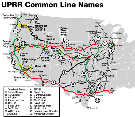
The bridge is located on an east/west Union Pacific main line—the Overland Route[5]—connecting Chicago to the west coast.[6]
New bridge
From 2006 to 2009, Union Pacific constructed a new double track concrete and steel bridge next to the old span.[7] During construction, the bridge was lengthened 160 feet (49 m) to the east due to instability of the bank caused by heavy rains in Spring 2008; this delayed completion by at least eight months.[8] The bridge opened to traffic on August 20, 2009, when the Union Pacific ran its first train across the new span.[7] The UP officially named the new viaduct the Kate Shelley Bridge. The new bridge can handle two trains simultaneously at 70 mph (110 km/h), and at 2,813 feet (857 m) long and 190 feet (58 m) high,[7] the new bridge is longer and slightly taller than the original. The original bridge was left in place.
Name confusion
In addition to the Boone Viaduct (completed 1901), a.k.a. the Kate Shelley High Bridge, and the Union Pacific Kate Shelley Bridge (completed 2009), at least two other bridges have been occasionally called the Kate Shelley (Shelly) bridge. The bridge at Moingona that Kate crossed was sometimes referred to as the Kate Shelly Bridge before the Boone Viaduct was complete. A new steel bridge was built to replace the old wooden Moingona one in 1894. The small stone bridge over Honey Creek near her house, where the pusher engine crashed, was also occasionally called the Kate Shelley (Shelly) Bridge.
There were and have been many high trestles in Boone County, such as the Boone & Scenic Valley Railroad's Bass Point High Bridge.[9]
New Kate Shelley Bridge | |
|---|---|
| Coordinates | 42°03′32″N 93°58′12″W |
| Carries | Heavy rail |
| Crosses | Des Moines River |
| Locale | Boone, Iowa |
| Maintained by | Union Pacific |
| Characteristics | |
| Material | Concrete and steel |
| Total length | 2,813 ft (857 m) |
| Height | 190 ft (58 m) |
| History | |
| Construction start | 2006 |
| Construction end | 2009 |
| Opened | 2009 |
|
| |
References
- "National Register Information System". National Register of Historic Places. National Park Service. March 13, 2009.
- http://www.kateshelley.com/about-kate.html
- W.C. Armstrong, The Boone Viaduct, The Iowa Engineer, Vol. 1, No. 1 (June 1901); pages 6-19
- AREMA - Rehabilitation of the Historic Kate Shelley High Bridge
- UPRR Common Line Names
- "Union Pacific in Iowa" (PDF). Retrieved 2012-02-07.
- New Kate Shelley Bridge Fast Facts
- "Delay for completion date of new UP bridge". Archived from the original on 2012-06-16. Retrieved 2012-02-07.
- http://www.kateshelley.com/bridges-of-boone-county.html
External links

- Article in Railroad Ties (p. 5), 20 Jan 2007
- 1902 picture of Kate Shelley High Bridge (Shorpy Archives)
- Historic American Engineering Record (HAER) No. IA-44, "Chicago & Northwestern Railroad Viaduct, Spanning Des Moines River at Chicago & Northwestern Railroad tracks, Boone vicinity, Boone County, IA"
- SAH Archipedia Building Entry
| Topics | |
|---|---|
| Lists by state |
|
| Lists by insular areas | |
| Lists by associated state | |
| Other areas | |
| Related | |
| |
| Boone |  | |
|---|---|---|
| Madrid | ||
| Ogden | ||
| Ridgeport | ||