Karpenisi
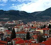
Karpenisi (Greek: Καρπενήσι, Greek pronunciation: [karpeˈnisi]) is a town in central Greece. It is the capital of the regional unit of Evrytania. Karpenisi is situated in the valley of the river Karpenisiotis (Καρπενησιώτης), a tributary of the Megdovas, in the southern part of the Pindus Mountains. Mount Tymfristos (2,315 m elevation) lies directly to the north of the town, and the foothills of mount Kaliakouda are in the south. Karpenisi has a ski resort and is a popular destination, especially during winter. It is called Switzerland of Greece for the resemblance with the mountainous country and its beauty, atypical for a Mediterranean place.[2]
Karpenisi Καρπενήσι | |
|---|---|
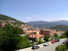 Part of the town | |
 Karpenisi Location within the region  | |
| Coordinates: 38°55′N 21°47′E | |
| Country | Greece |
| Administrative region | Central Greece |
| Regional unit | Evrytania |
| Government | |
| • Mayor | Nikos Souliotis(New Democracy) |
| Area | |
| • Municipality | 948.6 km2 (366.3 sq mi) |
| • Municipal unit | 250.9 km2 (96.9 sq mi) |
| Elevation | 960 m (3,150 ft) |
| Population (2011)[1] | |
| • Municipality | 13,105 |
| • Municipality density | 14/km2 (36/sq mi) |
| • Municipal unit | 8,575 |
| • Municipal unit density | 34/km2 (89/sq mi) |
| Community | |
| • Population | 7,348 (2011) |
| Time zone | UTC+2 (EET) |
| • Summer (DST) | UTC+3 (EEST) |
| Postal code | 361 00 |
| Area code(s) | 22370 |
| Vehicle registration | ΚΗ |
| Website | www.karpenissi.gr |
Municipality
The municipality Karpenisi was formed at the 2011 local government reform by the merger of the following 6 former municipalities, that became municipal units:[3]
- Domnista (Ampliani, Domnista, Krikello, Mesokomi, Psiana, Roska, Stavloi)
- Fourna (Fourna, Kleisto, Vracha)
- Karpenisi (Agia Vlacherna, Agios Andreas, Agios Nikolaos, Fidakia, Kalesmeno, Karpenisi, Koryschades, Myriki, Papparousi, Pavlopoulo, Sella, Stefani, Stenoma, Voutyro)
- Ktimenia (Agia Triada, Agios Charalampos, Chochlia, Domianoi, Petralona)
- Potamia (Aniada, Chelidonas, Dermati, Karitsa, Klafsi, Megalo Chorio, Mikro Chorio, Mouzilo, Nostimo, Sygkrellos)
- Prousos (Alestia, Aspropyrgos, Esochoria, Kastania, Katavothra, Prodromos, Prousos, Sarkini, Stavrochori, Tornos, Velota)
The municipality has an area of 948.570 km2, the municipal unit 250.887 km2.[4]
Mayor of Karpenisi
- Kostas Bakoyannis, 1 January 2011 – 31 August 2014
- Nikos Souliotis, since 1 September 2014
Historical population
| Year | Municipal unit | Municipality |
|---|---|---|
| 1981 | 5,230 | – |
| 1991 | 8,185 | – |
| 2001 | 9,390 | – |
| 2011 | 8,575 | 13,105 |
Notable people
- Zacharias Papantoniou (1877–1940), writer
- Ioannis Theodoropoulos, bronze medal in the pole vault 1896 Summer Olympics
- Georgios Kondylis (1878–1936), General of the Greek army and Prime Minister of Greece
- Charalambos Katsimitros (1886–1962), General of the Greek army who distinguished himself during the Greco-Italian War
- Pavlos Bakoyannis (1935–1989),Greek politician and journalist
Facts in Karpenisi
- Battle of Karpenisi (8 August 1823) during the Greek War of Independence
References
- "Απογραφή Πληθυσμού - Κατοικιών 2011. ΜΟΝΙΜΟΣ Πληθυσμός" (in Greek). Hellenic Statistical Authority.
- Dana Facaros; Linda Theodorou (2003). Greece. New Holland Publishers. p. 382. ISBN 978-1-86011-898-2.
- Kallikratis law Greece Ministry of Interior (in Greek)
- "Population & housing census 2001 (incl. area and average elevation)" (PDF) (in Greek). National Statistical Service of Greece. Archived from the original (PDF) on 21 September 2015.
- "Karpenisi, Greece". Archived from the original on 25 July 2011. Retrieved 7 October 2010.
External links
- GTP Travel Pages (Municipality) (in English and Greek)
- Tourist Guide of Karpenisi
| Wikimedia Commons has media related to Karpenisi. |
Administrative division of the Central Greece Region | ||
|---|---|---|
| Regional unit of Boeotia | 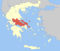 | |
| Regional unit of Euboea | ||
| Regional unit of Evrytania | ||
| Regional unit of Phocis | ||
| Regional unit of Phthiotis | ||
| ||