Kangri Garpo
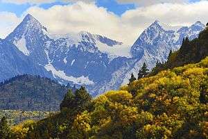
Kangri Garpo (Chinese: 岗日嘎布; pinyin: Gǎngrì Gābù) is a mountain range in eastern Tibet, located primarily in Nyingchi Prefecture as well as a portion of Qamdo Prefecture in the Tibet Autonomous Region, China. The mountain range lies to the east of the Himalayas and to the west of the Hengduan Mountains. The mountains are geographically a southern extension of the eastern Transhimalayas.
| Kangri Garpo | |
|---|---|
 | |
| Highest point | |
| Peak | Bairiga |
| Elevation | 6,882 m (22,579 ft) |
| Coordinates | 29°09′57″N 96°43′27″E |
| Naming | |
| Native name | 岗日嘎布 |
| Geography | |
| Country | China |
| Province | Tibet Autonomous Region |
Physical geography and climate
The Kangri Garpo stretch for approximately 280 km (170 mi) from west to east.[1] They lie at the eastern end of the Himalayan Range and were formed at the same time during the Indian subcontinent's collision with Eurasia. The Kangri Garpo are geologically related to the Himalayas, but are separated by the Yarlung Tsangpo's Grand Canyon. The eastern anchor of the Himalayas, Namcha Barwa, rises above the western Kangri Garpo just beyond the Yarlung Tsangpo. To the north, the Kangri Garpo are separated from the Nyenchen Tanglha by the Parlung Tsangpo River. To the northeast, the Kangri Garpo are connected with the Baxoila Range, sometimes considered the westernmost component range of the Hengduan Mountains. Further east, the Kangri Garpo are separated from the Baxoila by the Zayü River. To the south, the Kangri Garpo transition to the Indian Mishmi Hills, also known in China as the Qilinggong Mountains (祁灵公山).[2] The distinction between the Kangri Garpo and the Mishmi Hills is not well defined, and may only represent a difference of cultures on either on either side of the McMahon Line.
The highest peak of the Kangri Garpo, Bairiga or Ruoni, rises in the central portion of the range to an elevation of 6,882 m (22,579 ft) above sea level. Other notable peaks include Gemsongu at 6,450 m (21,160 ft), Kone Kangri at 6,347 m (20,823 ft), Yuhe Kangri at 6,327 m (20,758 ft), and Gheni at 6,177 m (20,266 ft).[3]
The Kangri Garpo form a high-altitude barrier at the northeastern-most limit of the Indian subcontinent. The mountains here are in the direct path of the northeast-moving South Asian monsoon which leads to Kangri Garpo being the wettest location on the Tibetan Plateau. This also leads to one of the highest concentrations of glaciers in the region. Notable glaciers include the scenic Midiu Glacier, the Ata Glacier (the lowest glacier in Tibet reaching an elevation of 2,440 m (8,010 ft)), and the 30 km (19 mi)-long Lhagu Glacier.[1]
Due to the heavy precipitation in the area, the Kangri Garpo support dense forests including the Northeastern Himalayan subalpine conifer forests at middle altitudes and Eastern Himalayan broadleaf forests at lower altitudes.[4][5] At higher altitudes, the mountains are covered by Eastern Himalayan alpine shrub and meadows.[6]
Human geography
The Kangri Garpo lie in the southeast part of Tibet, at the junction between Kham to the east, Ü-Tsang to the west, and South Asian hill tribes to the south. The Tibetan Poyul Kingdom enjoyed relative independence on the Kangri Garpo's northern slopes until the early 20th century.[7]
Today, the western Kangri Garpo are under the administration of Bomê County to the north and Mêdog County to the south. The bulk of the eastern Kangri Garpo are part of Zayü County while a small portion of the north-central Kangri Garpo are part of Baxoi County. All these counties are part of Nyingchi Prefecture, except for Baxoi which is part of Qamdo Prefecture.[2] To the south of the Kangri Garpo are the Mishmi Hills which lie primarily in Arunachal Pradesh, India but are also claimed by China. The McMahon Line passes just south of the Kangri Garpo.
The only significant towns in the mountain range are Zhamo in the north, Rawu in the northeast, and Zayü in the southeast. The only vehicular road to cross the Kangri Garpo is the road to Mêdog via Galong Pass in the western part of the mountains that was completed in 2013.[8][9] The northern portion of the Kangri Garpo are skirted by China National Highway 318 and have become a popular scenic destination for Chinese tourists. Access to this region of Tibet, however, is often restricted for foreigners.[10]
References
- Nakamura, Tamotsu (2001). "Kangri Garpo Range in Southeast Tibet" (PDF). Japanese Alpine News. 1. Retrieved 30 August 2017.
- Atlas of China. Beijing, China: SinoMaps Press. 2006. ISBN 9787503141782.
- Inoue, Tim. "Kangri Garpo Mountains" (PDF). Alpine Club of Kobe University. Retrieved 30 August 2017.
- "Northeastern Himalayan subalpine conifer forests". Global Species. Myers Enterprises II. Retrieved 11 September 2017.
- "Eastern Himalayan broadleaf forests". Global Species. Myers Enterprises II. Retrieved 11 September 2017.
- "Eastern Himalayan alpine shrub and meadows". Global Species. Myers Enterprises II. Retrieved 11 September 2017.
- Ryavec, Karl E. (2015). A Historical Atlas of Tibet. Chicago, IL: University of Chicago Press. ISBN 978-0226732442.
- China Highway Atlas. Beijing, China: China Communications Press. 2014. ISBN 9787114060656.
- Huaxia (17 April 2017). "Highway to heaven, and to China's most isolated county". New China. Retrieved 11 September 2017.
- Lobsang (29 August 2017). "2017 Tibet Travel Regulations". The Land of Snows. Retrieved 11 September 2017.