Kandy District
Kandy District (Sinhala: මහනුවර දිස්ත්රික්කය, Tamil: கண்டி மாவட்டம்) is a district of the Central Province of Sri Lanka. Its area is 1906.3 km².[2] The capital of the district is Kandy.
Kandy District මහනුවර දිස්ත්රික්කය கண்டி மாவட்டம் | |
|---|---|
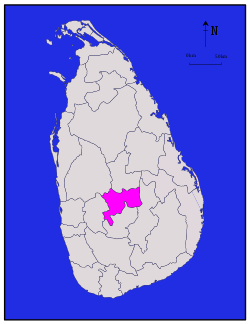 Map of Sri Lanka with Kandy District highlighted | |
| Coordinates: 7°15′N 80°45′E | |
| Country | Sri Lanka |
| Province | Central Province |
| Largest city | Kandy |
| Divisions | List
|
| Government | |
| • District Secretary | D. M. N. G. G. T. Karunarathne |
| • Local | List
|
| Area | |
| • Total | 1,940 km2 (750 sq mi) |
| • Land | 1,917 km2 (740 sq mi) |
| • Water | 23 km2 (9 sq mi) |
| Population (2012)[1] | |
| • Total | 1,369,899 |
| • Density | 710/km2 (1,800/sq mi) |
| Time zone | UTC+05:30 (Sri Lanka) |
| ISO 3166 code | LK-21 |
| Website | ds.gov.lk/dist_kandy |
Administrative divisions
| DS Division | Area (km2) [3] |
Population (2012 Census)[4] | Population Density (/km2) |
|---|---|---|---|
| Akurana | 31 | 67,195 | 2,135 |
| Delthota | 49 | 30,169 | 616 |
| Doluwa | 95 | 49,480 | 521 |
| Ganga Ihala Korale | 94 | 54,674 | 582 |
| Harispattuwa | 49 | 88,002 | 1,796 |
| Hatharaliyadda | 62 | 29,866 | 482 |
| Kandy Four Gravets | 59 | 157,330 | 2,667 |
| Kundasale | 81 | 127,278 | 1,571 |
| Medadumbara - Teldeniya | 196 | 60,783 | 310 |
| Minipe | 250 | 51,577 | 206 |
| Panvila | 93 | 26,186 | 282 |
| Pasbage Korale | 122 | 59,662 | 489 |
| Pathadumbara | 51 | 88,599 | 1,737 |
| Pathahewaheta | 84 | 58,031 | 691 |
| Poojapitiya | 59 | 57,879 | 981 |
| Thumpane | 54 | 37,356 | 692 |
| Udapalatha | 94 | 91,230 | 971 |
| Ududumbara | 277 | 22,408 | 81 |
| Udunuwara | 68 | 110,232 | 1,621 |
| Yatinuwara | 72 | 105,962 | 1,472 |
| Total | 1,940 | 1,369,899 | 706 |
Ethnic groups and religion
Religion in Kandy District (2011)[1]
| Ethnic groups | |||
|---|---|---|---|
| Sinhalese | 947,900 | (74%) | |
| Sri Lankan Moor | 169,968 | (13.27%) | |
| Indian Tamil | 103,622 | (8.09%) | |
| Sri Lankan Tamil | 52,052 | (4.06%) | |
| Sri Lankan Malay | 2,668 | (0.21%) | |
| Burgher | 2,128 | (0.17%) | |
| Other | 2,609 | (0.2%) | |
| Religions | |||
|---|---|---|---|
| Buddhism | 937,001 | (72.92%) | |
| Islam | 179,590 | (13.98%) | |
| Hinduism | 134,438 | (10.46%) | |
| Roman Catholic | 23,232 | (1.81%) | |
| Other Christian | 10,330 | (0.8%) | |
| Other | 437 | (0.03%) | |
Major cities
- Kandy municipal council
Suburbs of city of Kandy
Big towns
- Gampola urban council
- Nawalapitiya UC
Other towns
References
- Department of Census and Statistics,The Census of Population and Housing of Sri Lanka-2011
- Kandy District Secretariat Archived 2009-05-18 at the Wayback Machine
- "Land area by province, district and divisional secretariat division" (PDF). Statistical Abstract 2011. Department of Census & Statistics, Sri Lanka. Archived from the original (PDF) on 2012-11-13.
- "A6 : Population by ethnicity and district according to Divisional Secretary's Division, 2012". Census of Population & Housing, 2011. Department of Census & Statistics, Sri Lanka.
| Central Province | ||
|---|---|---|
| Eastern Province | ||
| North Central Province | ||
| Northern Province | ||
| North Western Province | ||
| Sabaragamuwa Province | ||
| Southern Province | ||
| Uva Province | ||
| Western Province | ||
This article is issued from Wikipedia. The text is licensed under Creative Commons - Attribution - Sharealike. Additional terms may apply for the media files.