Kamen Opasnosti
Kamen Opasnosti (Russian: Камень Опасности, lit. 'Dangerous Rock', Japanese 二丈岩 Nijouiwa) is an islet group of rocks, in La Pérouse Strait and the Sea of Okhotsk.
Kamen Opasnosti Камень Опасности | |
|---|---|
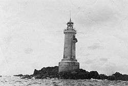 Lighthouse on Kamen Opasnosti. | |
 Kamen Opasnosti | |
| Coordinates: 45.7875°N 142.217°E | |
| Country | Russian Federation |
| Federal subject | Far Eastern Federal District |
| Oblast | Sakhalin Oblast |
Geography
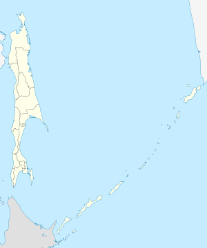
Kamen Opasnosti is located around 14 kilometres (8.7 mi) southeast of Cape Crillon, the southernmost point of Sakhalin island.
It is a small group of bare rocks, devoid of vegetation. Its length is 150 metres (490 ft), its width is 50 metres (160 ft), and its highest point is approx. 8 metres (26 ft).
History
The rocks were a great hindrance to marine traffic in La Pérouse Strait, aggravated by frequent dense fogs in the summertime. To avoid possible collision, ships had to set some of their crew members on guard to locate Kamen Opasnosti by listening to the roar of sea lions living on it. A lighthouse was finally constructed on the rocks in 1913, during the Japanese administration of the area.
See also
- Islands of the Sea of Okhotsk
- Islands of the Russian Far East